


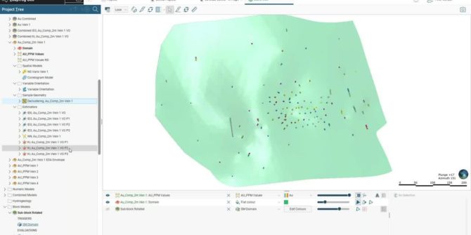
Introduction to Leapfrog Edge, a dynamic grade thickness workflow (Remote Roundup 2021)
Overview SpeakersPeter Oshust Senior Geologist Business Development - Seequent Duration39 minJTNDJTIxLS0lMjBUaGUlMjBzY3JpcHQlMjB0YWclMjBzaG91bGQlMjBsaXZlJTIwaW4lMjB0aGUlMjBoZWFkJTIwb2YlMjB5b3VyJTIwcGFnZSUyMGlmJTIwYXQlMjBhbGwlMjBwb3NzaWJsZSUyMC0tJTNFJTNDc2NyaXB0JTIwdHlwZSUzRCUyMnRleHQlMkZqYXZhc2NyaXB0JTIyJTIwYXN5bmMlMjBzcmMlM0QlMjJodHRwcyUzQSUyRiUyRnBsYXkudmlkeWFyZC5jb20lMkZlbWJlZCUyRnY0LmpzJTIyJTNFJTNDJTJGc2NyaXB0JTNFJTNDJTIxLS0lMjBQJTBBdXQlMjB0aGlzJTIwd2hlcmV2ZXIlMjB5b3UlMjB3b3VsZCUyMGxpa2UlMjB5b3VyJTIwcGxheWVyJTIwdG8lMjBhcHBlYXIlMjAtLSUzRSUzQ2ltZyUyMCUyMHN0eWxlJTNEJTIyd2lkdGglM0ElMjAxMDAlMjUlM0IlMjBtYXJnaW4lM0ElMjBhdXRvJTNCJTIwZGlzcGxheSUzQSUyMGJsb2NrJTNCJTIyJTIwJTBBJTIwY2xhc3MlM0QlMjJ2aWR5YXJkLXBsYXllci1lbWJlZCUyMiUyMCUyMCUwQXNyYyUzRCUyMmh0dHBzJTNBJTJGJTJGcGxheS52aWR5YXJkLmNvbSUyRlRLbW9LVlR2UzR2VFc5N2NNa0dBSnguanBnJTIyJTIwJTIwZGF0YS11dWlkJTNEJTIyVEttb0tWVHZTNHZUVzk3Y01rR0FKeCUyMiUyMCUyMGRhdGEtdiUzRCUyMjQlMjIlMjAlMjBkYXRhLXR5cGUlM0QlMjJpbmxpbmUlMjIlMkYlM0U= Video Transcript [00:00:00.899] (gentle music) [00:00:10.870] <v Peter>Good morning or good afternoon everyone</v> [00:00:14.078]
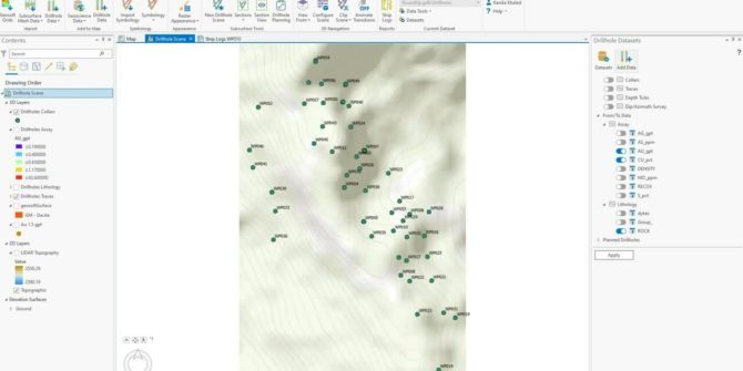
Target for ArcGIS Pro: importing and visualizing your geoscience data (Remote Roundup 2021)
We will show you various ways of importing data combined with 2D and 3D visualization. Come check out what’s included in the latest release of
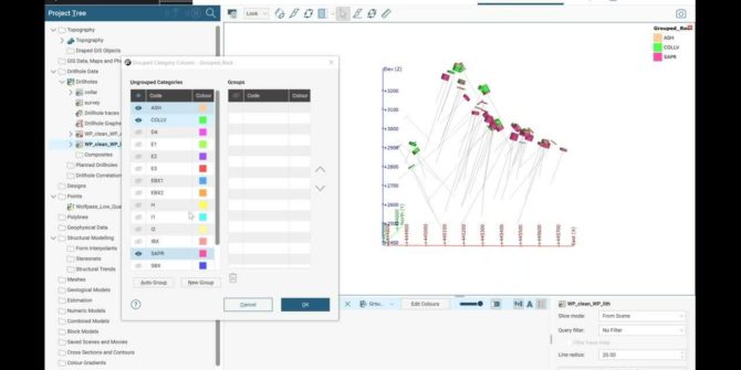
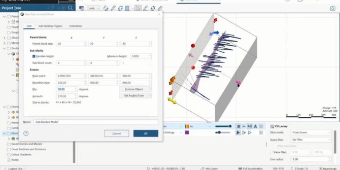
Geological modeling with drillholes + What’s new in Geo (Remote Roundup 2021)
Geological units to be modeled include an erosional surface, a vein system, and 2 diorite intrusions. Wrap up the demo with a tour of the
Oasis montaj: redesigned filtering (Remote Roundup 2021)
Learn how you can save time and with our updated and interactive filtering in Oasis montaj.
Accelerated Computing
Volsung can make use of NVIDIA GPUs to significantly accelerate computational tasks.The above chart shows the speedup achieved using Volsung on a benchmark model with
2D Estimation in Leapfrog Geo and Edge with SRK Consulting
He includes the step by step process in Leapfrog Geo and Edge and his practical tips. Overview SpeakersRobin Simpson SRK ConsultingDuration35 minJTNDJTIxLS0lMjBUaGUlMjBzY3JpcHQlMjB0YWclMjBzaG91bGQlMjBsaXZlJTIwaW4lMjB0aGUlMjBoZWFkJTIwb2YlMjB5b3VyJTIwcGFnZSUyMGlmJTIwYXQlMjBhbGwlMjBwb3NzaWJsZSUyMC0tJTNFJTBBJTNDc2NyaXB0JTIwdHlwZSUzRCUyMnRleHQlMkZqYXZhc2NyaXB0JTIyJTIwYXN5bmMlMjBzcmMlM0QlMjJodHRwcyUzQSUyRiUyRnBsYXkudmlkeWFyZC5jb20lMkZlbWJlZCUyRnY0LmpzJTIyJTNFJTNDJTJGc2NyaXB0JTNFJTBBJTBBJTNDJTIxLS0lMjBQdXQlMjB0aGlzJTIwd2hlcmV2ZXIlMjB5b3UlMjB3b3VsZCUyMGxpa2UlMjB5b3VyJTIwcGxheWVyJTIwdG8lMjBhcHBlYXIlMjAtLSUzRSUwQSUzQ2ltZyUwQSUyMCUyMHN0eWxlJTNEJTIyd2lkdGglM0ElMjAxMDAlMjUlM0IlMjBtYXJnaW4lM0ElMjBhdXRvJTNCJTIwZGlzcGxheSUzQSUyMGJsb2NrJTNCJTIyJTBBJTIwJTIwY2xhc3MlM0QlMjJ2aWR5YXJkLXBsYXllci1lbWJlZCUyMiUwQSUyMCUyMHNyYyUzRCUyMmh0dHBzJTNBJTJGJTJGcGxheS52aWR5YXJkLmNvbSUyRlp1bmd4eU5lUGZYaEJxTHhEWWQ3NHQuanBnJTIyJTBBJTIwJTIwZGF0YS11dWlkJTNEJTIyWnVuZ3h5TmVQZlhoQnFMeERZZDc0dCUyMiUwQSUyMCUyMGRhdGEtdiUzRCUyMjQlMjIlMEElMjAlMjBkYXRhLXR5cGUlM0QlMjJpbmxpbmUlMjIlMEElMkYlM0UlMEE= Video Transcript [00:00:00.796]
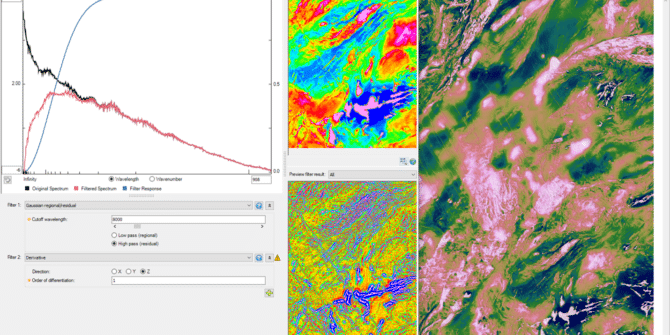
Introducing 2D Filtering for more intuitive, visual workflows
The latest release of Oasis montaj is one of the largest in years with updates to key algorithms delivering powerful performance and optimised workflows. One
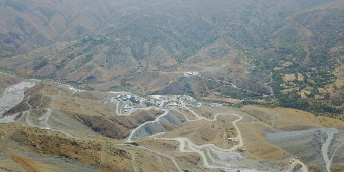
How Seequent is helping Yılmaden save between USD 500,000 and USD 1 Million on their annual drilling budget.
Seequent’s Leapfrog Geo and Seequent Central have been introduced to Yılmaden Holding’s mining camps in Kazakhstan and Turkey increasing drilling accuracy by 22% and decreasing