Work with a dynamic solution built from the ground up for electromagnetic and electrical survey data.
Refine your workflow from raw data to geophysical models and present confidently with AGS Workbench
Easily process, invert, and visualise EM, ERT, and IP data using a purpose-built application
Request a demoRequest a trialSave time for interpretation
One workflow for processing, inversion modelling, and visualisation
AGS Workbench is a powerful platform developed initially at Aarhus University to help protect groundwater resources by modelling the subsurface across Denmark. It is a leading solution for processing, inverting, and visualising electromagnetic and resistivity data using purpose-built extensions and provides an integrated solution that supports the entire workflow, independent of data types.
Extract value from IP data
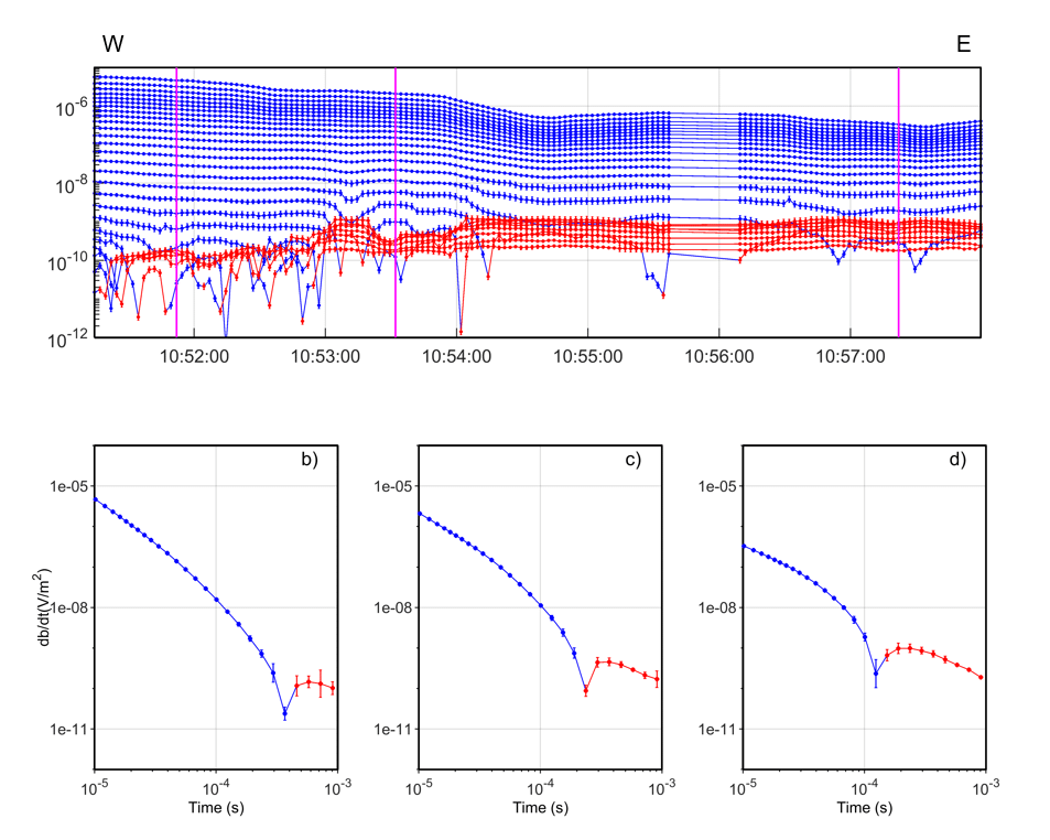
Induced polarisation effects are common in electromagnetic data but are often discarded as noise. With Workbench, you can model IP effects alongside resistivity and generate models that resemble the true resistivity of the subsurface.
Model time-domain electromagnetic-induced polarisation effects with Workbench’s Cole-Cole or Maximum Phase Angle inversion. Simultaneously modelling IP and resistivity parameters can reduce data misfits and artefacts and produce geologically sound geophysical models.
Streamline data import and integration
Import any size dataset from ground or airborne EM or ERT/IP surveys with custom-built importers for industry-standard instruments, system configurations, and file formats (e.g., SkyTEM, tTEM, .dt1). Imported models can be used as constraints or a starting point for new inversions. Compare inversion results to boreholes, geophysical logs, or other available data in the same workspace. All data is tightly integrated with the GIS for an optimal data handling experience.
Run efficient and powerful inversions
Workbench relies on Aarhus inversion code (AarhusInv) for efficient, high-performance modelling and inversion of airborne and ground-based EM, GCM, ERT, MRS, and TDIP data. 1D models can be laterally (LCI) or spatially (SCI) constrained during inversion in AarhusInv to create pseudo 2D and 3D models. The inversion code is designed to handle large-scale airborne EM surveys and supports multi-CPU cores with high parallel efficiency. In addition to generating resistivity models, it calculates a depth of investigation (DOI) value and data residual for each model. AarhusInv supports LCI and SCI setups, TEM IP inversion, smooth, blocky, sharp, layered models, and all industry-leading instruments. Pay per usage of the ACI (Aarhus Computing Infrastructure) is available when high computational power is required for demanding inversion jobs.
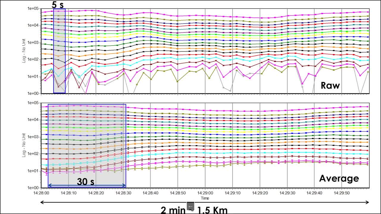
Auto process TEM data
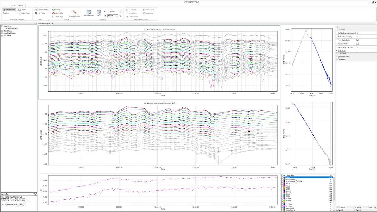
Visualise raw and averaged data to identify background noise caused by powerlines, pipes, and cables and remove affected data by auto processing or manual inspection.
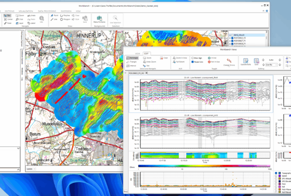
Control your visualisation
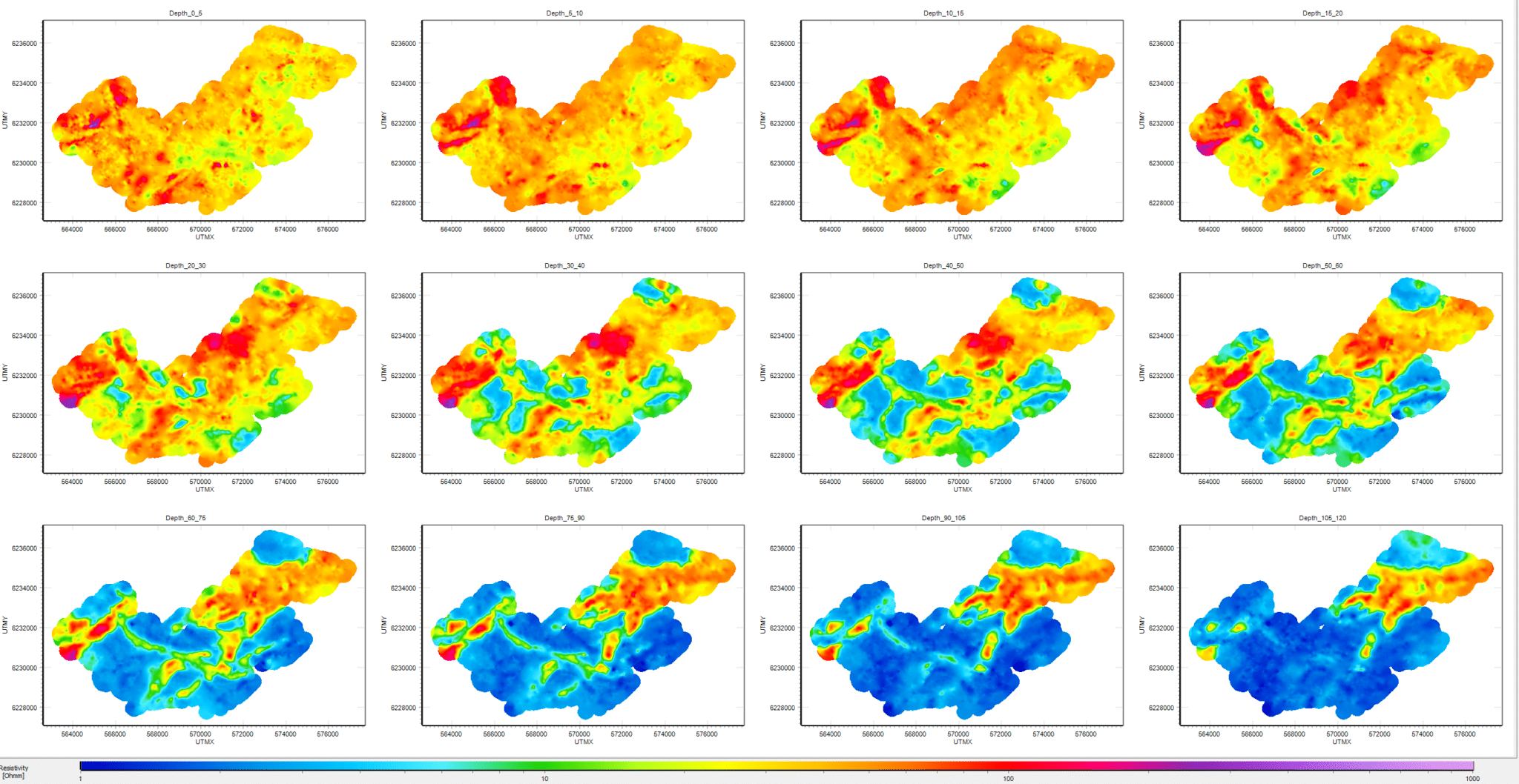
Extract resistivity-depth slices, depth-to-layer boundaries, and clay thickness with thematic modelling and visualisation tools. Use the QC tool to create GIS themes to visualise datasets, depth of investigation, system geometry, and data parameters. Draw 2D sections directly from the GIS, and add resistivity models, boreholes, and more to the section. Visualise 2D and 3D grids in the 3D viewer and generate smooth, blocky, sharp, or few-layered models to fit any interpretation requirement.
Try AGS Workbench
Get started todayQuickly transform raw data into interpretation using Workbench's features
Views
Views, a versatile interactive tool in Workbench, is used to process and visualise both raw data and inverted models from EM and streamed ERT data. Specialised “views” offer distinct settings that enable you to tailor visualisations to your workflow and goals. so that you can create, save, modify, and sync data visualisations seamlessly.
GIS Platform
Workbench is developed around a GIS platform that integrates with processing and visualization tools, including Views, the 3D Viewer, and PDF Creator.
Color Scale Editor
The Workbench Color Scale Editor is a tool that enables comprehensive customisation of colour scales for selected visualisations across sections, the QC tool, the GIS platform, the PDF Creator, and the 3D Viewer.
Quality Check (QC) Tool
Use the Workbench QC Tool to create point themes, grids, and images of data and model parameters on the GIS Platform. Display model fit, uncertainty areas, Depth Of Investigation (DOI), inverted vs. starting parameters, and more. Access a range of over 60 QC themes.
Themes
Through Workbench Themes, you can extract geophysical properties like resistivities, conductivities, depths, thickness, etc., from the inversion models. These properties can be visualised using depth/elevation slices, point themes, interpolated grids, and images.
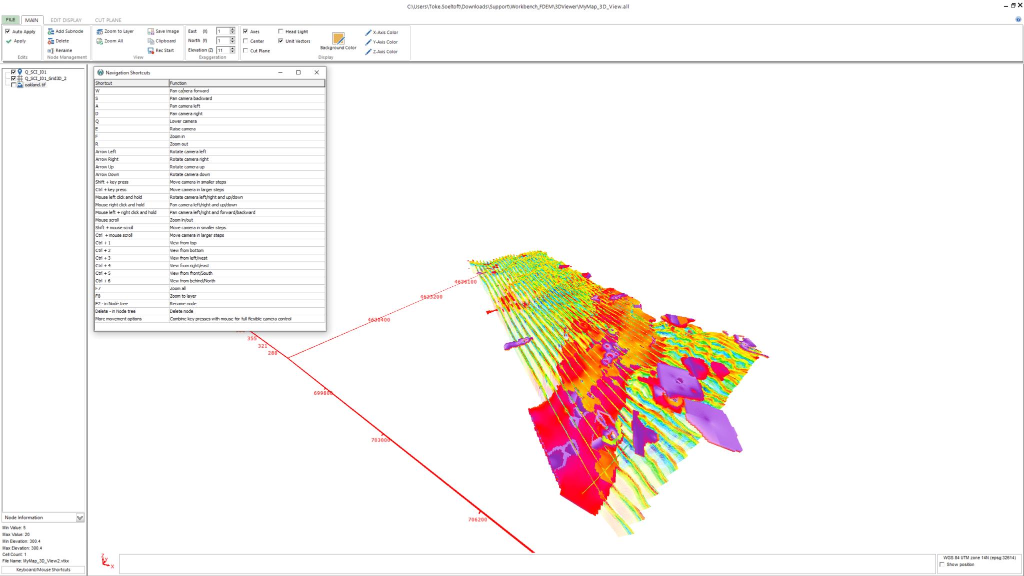
3D Viewer
The Workbench 3D Viewer is a comprehensive tool that facilitates 3D visualisation of data, models, boreholes, maps, and more.
Borehole Logs
Incorporate borehole lithology logs and geophysical logs to showcase them on GIS, model sections, and the 3D Viewer. Use a conductivity log as a priori information in the SCI inversion process.
AarhusInv Inversion Code
AarhusInv is high-performance modelling and inversion code that supports a wide range of geophysical data types, configurations, and source-receiver types.