


Seequent is the Bentley Subsurface Company
Seequent’s software helps you manage, model and analyse data faster for better decision making. Models are easily updated with new data, so teams can respond swiftly to changing conditions or new client direction. Seequent’s tools integrate your entire geotechnical workflow and connect to Bentley System’s software suite to ensure subsurface data is effectively incorporated into infrastructure design and construction.

Of the top international civil engineering design firms use Seequent software
Years experience enabling success in civil engineering
Satisfaction with our front-line help and support
THE INFRASTRUCTURE LIFECYCLE
Subsurface intelligence for better decision-making across the infrastructure lifecycle
Explore each phase of the lifecycle to learn more about our trusted, proven solutions at every stage
01/Design


02/Build
03/Operate
04/Maintain
05/Full Lifecycle
See how better subsurface insights can accelerate your project delivery
Contact us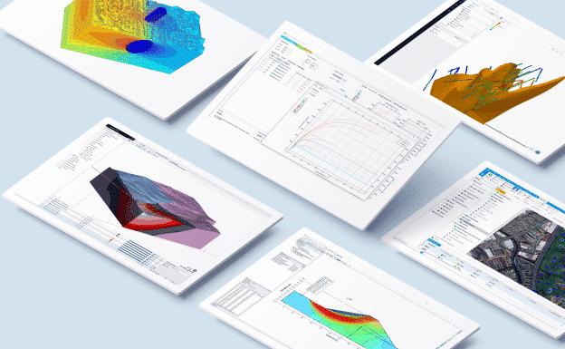
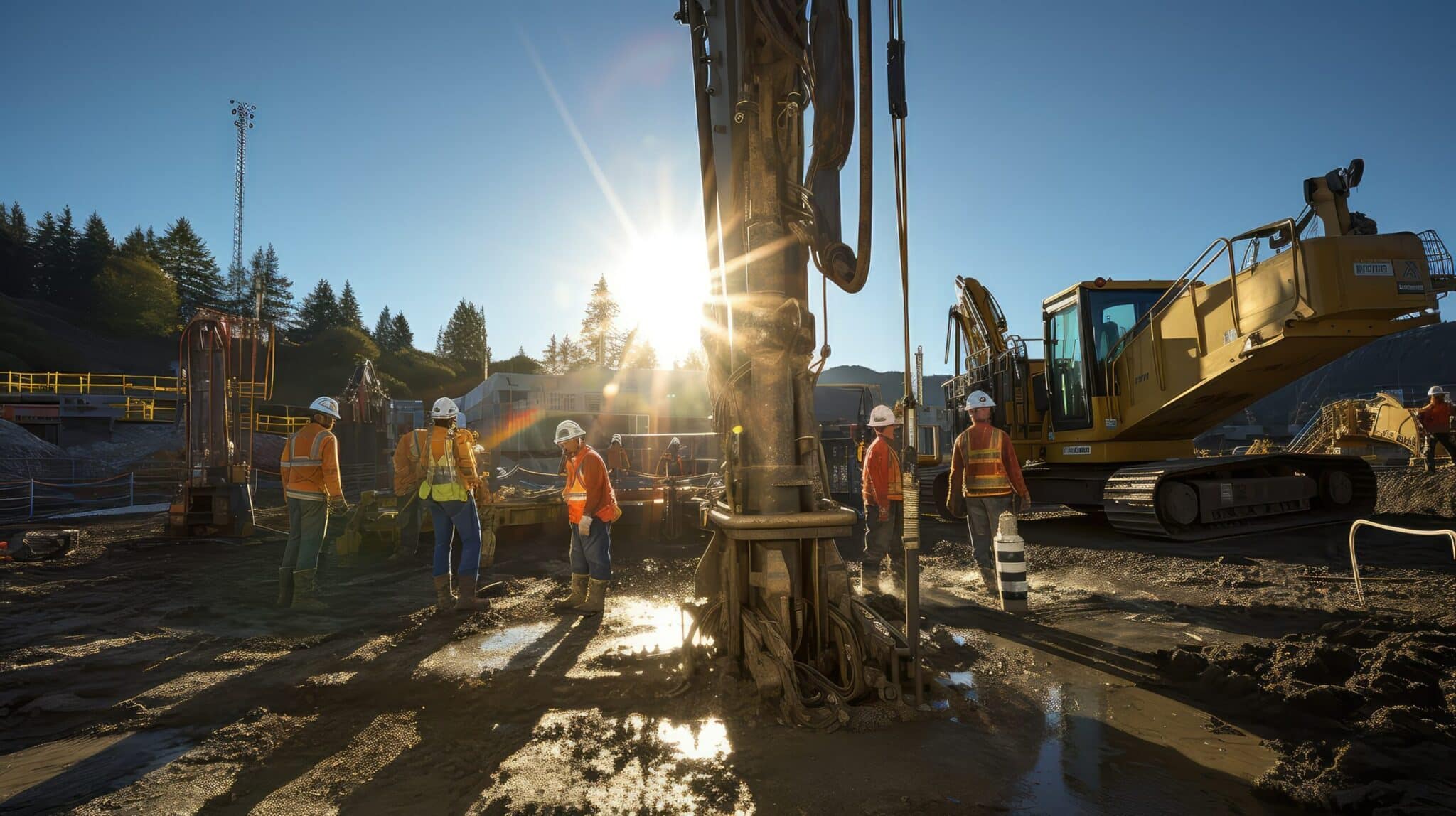
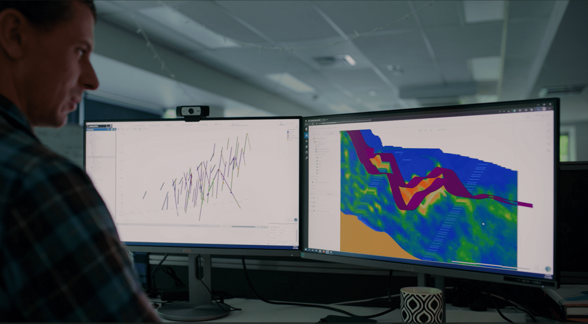
Geotechnical workflow
Connect geotechnical data, interpretative modelling, and numerical analysis on road and rail projects and better understand the underground for faster decision-making. Bring the richness of subsurface information directly into the design process with OpenGround’s geotechnical extension for Bentley’s civil design applications.
OpenGround
Starting fromUSD $2,420.00
12 months named license
Only 12 month named licences are available to purchase online. For shared and enterprise licences, please contact us.
Named license - allows unlimited use of the software for a single dedicated user during the subscription period.
Shared license - allows any number of users to access the software over the subscription period, limited to one user per seat at any given time.
OpenGround is a secure, cloud-based geotechnical information management platform for collecting, reporting, managing, visualising, analysing, and accessing geotechnical data.
- Learn more
-
Buy Now

Proceed to cart
Seequent products can be purchased securely through Bentley's eStore. Seequent is the Bentley subsurface company.
Prices shown on Bentley's eStore will be displayed in your local currency excluding tax.

Leapfrog Works
Build categorical and numerical models from site investigation and boring data in a fraction of the time.
Seequent Central
Cloud-based Seequent Central offers shared 3D visualisation, team collaboration, and tracking of geological data within a single, auditable environment.

PLAXIS 2D
Starting fromUSD $4,450.00
12 months named license
Only 12 month named licences are available to purchase online. For shared and enterprise licences, please contact us.
Named license - allows unlimited use of the software for a single dedicated user during the subscription period.
Shared license - allows any number of users to access the software over the subscription period, limited to one user per seat at any given time.
PLAXIS 2D is the industry standard for geotechnical 2D finite element analysis of deformation and stability in soil and rock - powerful, trusted, awarded and user-friendly.
- Learn more
-
Buy Now
Proceed to cart
Seequent products can be purchased securely through Bentley's eStore. Seequent is the Bentley subsurface company.
Prices shown on Bentley's eStore will be displayed in your local currency excluding tax.

PLAXIS 3D
Starting fromUSD $11,675.00
12 months named license
Only 12 month named licences are available to purchase online. For shared and enterprise licences, please contact us.
Named license - allows unlimited use of the software for a single dedicated user during the subscription period.
Shared license - allows any number of users to access the software over the subscription period, limited to one user per seat at any given time.
PLAXIS 3D is the industry standard for geotechnical 3D finite element analysis of deformation and stability in soil and rock - powerful, trusted, awarded and user-friendly.
- Learn more
-
Buy Now
Proceed to cart
Seequent products can be purchased securely through Bentley's eStore. Seequent is the Bentley subsurface company.
Prices shown on Bentley's eStore will be displayed in your local currency excluding tax.

GeoStudio 2D
Starting fromUSD $3,200.00
12 months named license
Only 12 month named licences are available to purchase online. For shared and enterprise licences, please contact us.
Named license - allows unlimited use of the software for a single dedicated user during the subscription period.
Shared license - allows any number of users to access the software over the subscription period, limited to one user per seat at any given time.
GeoStudio 2D is an integrated software suite for modelling slope stability, groundwater flow, ground deformation, and more in soil and rock.
- Learn more
-
Buy Now
Proceed to cart
Seequent products can be purchased securely through Bentley's eStore. Seequent is the Bentley subsurface company.
Prices shown on Bentley's eStore will be displayed in your local currency excluding tax.
GeoStudio 3D
Starting fromUSD $8,190.00
12 months named license
Only 12 month named licences are available to purchase online. For shared and enterprise licences, please contact us.
Named license - allows unlimited use of the software for a single dedicated user during the subscription period.
Shared license - allows any number of users to access the software over the subscription period, limited to one user per seat at any given time.
GeoStudio 3D is an award-winning integrated software suite for modelling 3D slope stability and groundwater flow in soil and rock.
- Learn more
-
Buy Now
Proceed to cart
Seequent products can be purchased securely through Bentley's eStore. Seequent is the Bentley subsurface company.
Prices shown on Bentley's eStore will be displayed in your local currency excluding tax.

Bentley Road & Site Design
Use comprehensive 3D modelling, design, and analysis software to efficiently take multi-disciplinary projects from field to finish.

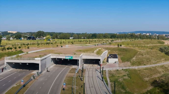
Bentley Rail Design
Redefine how rail and transit infrastructure is designed, built, and operated with multidiscipline data exchange and handover to support construction through maintenance.

Bentley Bridge Design
Leverage proven tools for complex modelling, design, and analysis of all bridge types on both existing and new structures.
Transform your transportation projects with integrated solutions
Learn moreIntegrate geotechnical data, ground interpretation, physical modelling and geotechnical design to create a unique subsurface model of your tunnel and underground assets. Give stakeholders the insights they need for informed decisions. Bring the richness of subsurface information and analysis directly into the design process with Bentley’s OpenTunnel Designer.
OpenGround
Starting fromUSD $2,420.00
12 months named license
Only 12 month named licences are available to purchase online. For shared and enterprise licences, please contact us.
Named license - allows unlimited use of the software for a single dedicated user during the subscription period.
Shared license - allows any number of users to access the software over the subscription period, limited to one user per seat at any given time.
OpenGround is a secure, cloud-based geotechnical information management platform for collecting, reporting, managing, visualising, analysing, and accessing geotechnical data.
- Learn more
-
Buy Now
Proceed to cart
Seequent products can be purchased securely through Bentley's eStore. Seequent is the Bentley subsurface company.
Prices shown on Bentley's eStore will be displayed in your local currency excluding tax.
Leapfrog Works
Build categorical and numerical models from site investigation and boring data in a fraction of the time.
Seequent Central
Cloud-based Seequent Central offers shared 3D visualisation, team collaboration, and tracking of geological data within a single, auditable environment.
PLAXIS 2D
Starting fromUSD $4,450.00
12 months named license
Only 12 month named licences are available to purchase online. For shared and enterprise licences, please contact us.
Named license - allows unlimited use of the software for a single dedicated user during the subscription period.
Shared license - allows any number of users to access the software over the subscription period, limited to one user per seat at any given time.
PLAXIS 2D is the industry standard for geotechnical 2D finite element analysis of deformation and stability in soil and rock - powerful, trusted, awarded and user-friendly.
- Learn more
-
Buy Now
Proceed to cart
Seequent products can be purchased securely through Bentley's eStore. Seequent is the Bentley subsurface company.
Prices shown on Bentley's eStore will be displayed in your local currency excluding tax.
PLAXIS 3D
Starting fromUSD $11,675.00
12 months named license
Only 12 month named licences are available to purchase online. For shared and enterprise licences, please contact us.
Named license - allows unlimited use of the software for a single dedicated user during the subscription period.
Shared license - allows any number of users to access the software over the subscription period, limited to one user per seat at any given time.
PLAXIS 3D is the industry standard for geotechnical 3D finite element analysis of deformation and stability in soil and rock - powerful, trusted, awarded and user-friendly.
- Learn more
-
Buy Now
Proceed to cart
Seequent products can be purchased securely through Bentley's eStore. Seequent is the Bentley subsurface company.
Prices shown on Bentley's eStore will be displayed in your local currency excluding tax.
GeoStudio 2D
Starting fromUSD $3,200.00
12 months named license
Only 12 month named licences are available to purchase online. For shared and enterprise licences, please contact us.
Named license - allows unlimited use of the software for a single dedicated user during the subscription period.
Shared license - allows any number of users to access the software over the subscription period, limited to one user per seat at any given time.
GeoStudio 2D is an integrated software suite for modelling slope stability, groundwater flow, ground deformation, and more in soil and rock.
- Learn more
-
Buy Now
Proceed to cart
Seequent products can be purchased securely through Bentley's eStore. Seequent is the Bentley subsurface company.
Prices shown on Bentley's eStore will be displayed in your local currency excluding tax.
GeoStudio 3D
Starting fromUSD $8,190.00
12 months named license
Only 12 month named licences are available to purchase online. For shared and enterprise licences, please contact us.
Named license - allows unlimited use of the software for a single dedicated user during the subscription period.
Shared license - allows any number of users to access the software over the subscription period, limited to one user per seat at any given time.
GeoStudio 3D is an award-winning integrated software suite for modelling 3D slope stability and groundwater flow in soil and rock.
- Learn more
-
Buy Now
Proceed to cart
Seequent products can be purchased securely through Bentley's eStore. Seequent is the Bentley subsurface company.
Prices shown on Bentley's eStore will be displayed in your local currency excluding tax.
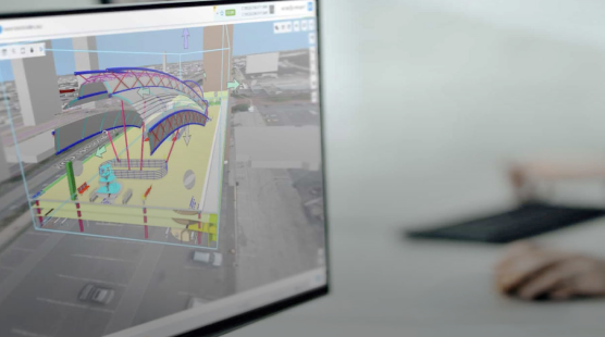
Bentley OpenTunnel Designer
Automate tunnel modelling, enable multi-discipline collaboration, and conveniently import models into PLAXIS for analysis.
Transform your tunnelling projects with integrated solutions
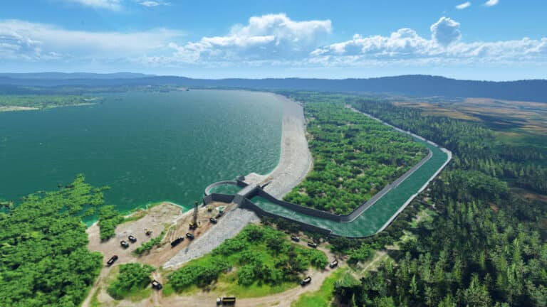
Learn moreAccelerate modelling and analysis for dams, levees, and embankments for greater resiliency and for water and energy security. Leverage Bentley’s digital twin technology to bring engineering and operational data together into a single, powerful unified view.

Res2DInv and Res3DInv (Old)
See results fast – easily process and invert your Resistivity and Induced Polarization data in two clicks.
OpenGround
Starting fromUSD $2,420.00
12 months named license
Only 12 month named licences are available to purchase online. For shared and enterprise licences, please contact us.
Named license - allows unlimited use of the software for a single dedicated user during the subscription period.
Shared license - allows any number of users to access the software over the subscription period, limited to one user per seat at any given time.
OpenGround is a secure, cloud-based geotechnical information management platform for collecting, reporting, managing, visualising, analysing, and accessing geotechnical data.
- Learn more
-
Buy Now
Proceed to cart
Seequent products can be purchased securely through Bentley's eStore. Seequent is the Bentley subsurface company.
Prices shown on Bentley's eStore will be displayed in your local currency excluding tax.
Seequent Central
Cloud-based Seequent Central offers shared 3D visualisation, team collaboration, and tracking of geological data within a single, auditable environment.
Leapfrog Works
Build categorical and numerical models from site investigation and boring data in a fraction of the time.
PLAXIS 2D
Starting fromUSD $4,450.00
12 months named license
Only 12 month named licences are available to purchase online. For shared and enterprise licences, please contact us.
Named license - allows unlimited use of the software for a single dedicated user during the subscription period.
Shared license - allows any number of users to access the software over the subscription period, limited to one user per seat at any given time.
PLAXIS 2D is the industry standard for geotechnical 2D finite element analysis of deformation and stability in soil and rock - powerful, trusted, awarded and user-friendly.
- Learn more
-
Buy Now
Proceed to cart
Seequent products can be purchased securely through Bentley's eStore. Seequent is the Bentley subsurface company.
Prices shown on Bentley's eStore will be displayed in your local currency excluding tax.
PLAXIS 3D
Starting fromUSD $11,675.00
12 months named license
Only 12 month named licences are available to purchase online. For shared and enterprise licences, please contact us.
Named license - allows unlimited use of the software for a single dedicated user during the subscription period.
Shared license - allows any number of users to access the software over the subscription period, limited to one user per seat at any given time.
PLAXIS 3D is the industry standard for geotechnical 3D finite element analysis of deformation and stability in soil and rock - powerful, trusted, awarded and user-friendly.
- Learn more
-
Buy Now
Proceed to cart
Seequent products can be purchased securely through Bentley's eStore. Seequent is the Bentley subsurface company.
Prices shown on Bentley's eStore will be displayed in your local currency excluding tax.
GeoStudio 2D
Starting fromUSD $3,200.00
12 months named license
Only 12 month named licences are available to purchase online. For shared and enterprise licences, please contact us.
Named license - allows unlimited use of the software for a single dedicated user during the subscription period.
Shared license - allows any number of users to access the software over the subscription period, limited to one user per seat at any given time.
GeoStudio 2D is an integrated software suite for modelling slope stability, groundwater flow, ground deformation, and more in soil and rock.
- Learn more
-
Buy Now
Proceed to cart
Seequent products can be purchased securely through Bentley's eStore. Seequent is the Bentley subsurface company.
Prices shown on Bentley's eStore will be displayed in your local currency excluding tax.
GeoStudio 3D
Starting fromUSD $8,190.00
12 months named license
Only 12 month named licences are available to purchase online. For shared and enterprise licences, please contact us.
Named license - allows unlimited use of the software for a single dedicated user during the subscription period.
Shared license - allows any number of users to access the software over the subscription period, limited to one user per seat at any given time.
GeoStudio 3D is an award-winning integrated software suite for modelling 3D slope stability and groundwater flow in soil and rock.
- Learn more
-
Buy Now
Proceed to cart
Seequent products can be purchased securely through Bentley's eStore. Seequent is the Bentley subsurface company.
Prices shown on Bentley's eStore will be displayed in your local currency excluding tax.

Bentley Civil WorkSuite
Design and analyse projects better, faster, and with more confidence using an end-to-end solution for civil engineering projects.

Bentley SYNCHRO
Capture, analyse, and optimise construction data in a full digital context for faster, safer, and more efficient project delivery.
Bentley ProjectWise
Share data and streamline workflows across project phases to maximise insights, learnings, and reuse from previous projects.

Bentley OpenFlows Water
Analyse and design complex stormwater systems, optimising system design, minimising capital investments, reducing stormwater flooding risk, and ensuring regulatory compliance.

Bentley iTwin Platform
Develop on an open platform for building SaaS solutions to design, build, and operate infrastructure assets.
INSIGHTS & IMPACT
Delivering success across the industry
Discover the latest customer stories and industry insights from Seequent


Together, let's build the foundations for more resilient infrastructure.
Free training and support
Grow your geoscience knowledge, connect with peers, and refresh your skills
Seequent Community
Discover new opportunities, connect with peers, and share insights and best practices with others in your field.
Visit Seequent CommunityLearning Centre
Get started fast or upskill whilst working with our onboarding and advanced free eLearning courses.
Visit Seequent Learning CentreSeequent Help
Find answers to your technical questions and get the most out of your product, with our in-depth product help information.
Visit Seequent Help