


Oasis montaj: redesigned filtering (Remote Roundup 2021)
Learn how you can save time and with our updated and interactive filtering in Oasis montaj.
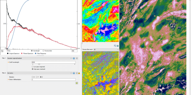
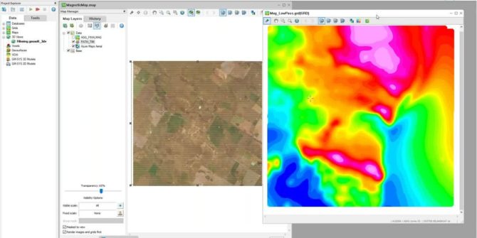
Introducing 2D Filtering for more intuitive, visual workflows
The latest release of Oasis montaj is one of the largest in years with updates to key algorithms delivering powerful performance and optimised workflows. One
Getting Started with Oasis montaj
Welcome to Oasis montaj, to start, you need to complete a few simple steps. Create your Seequent ID Your Seequent ID is your business email
Don’t let your data go to sleep
If your mining business is seeking to be successful and sustainable, no piece of data should go to waste. It’s a required talent among the
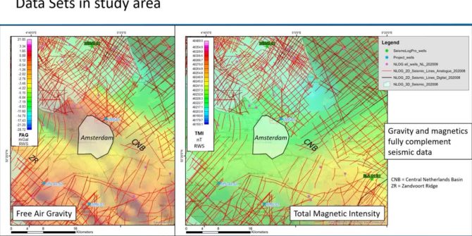
Innovative integrated exploration approach for geothermal reservoirs, a case study from the Netherlands
The energy transition in the Netherlands requires a sustainable and renewable supply of heat besides electricity that at present is still largely provided by fossil
Geosoft 9.9 – Discover the latest enhancements to Oasis montaj, Target and VOXI
This webinar is the best place to learn how the new functionality can improve efficiency in your workflows, give you more flexibility and help you
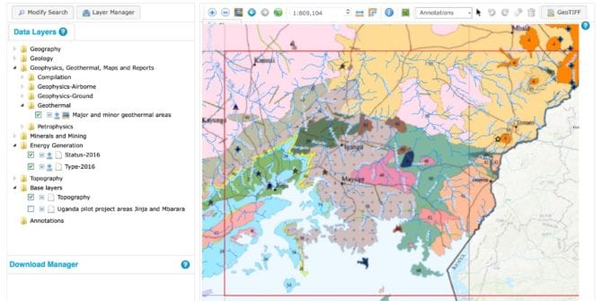
Uganda enables a sustainable future with geoscience data
In October 2019, Seequent announced the launch of the Uganda Geoscience Data Portal, supported by an international consortium that aims to improve the geoscience understanding
UXO Target Analysis
Target Analysis Creating and editing target polygons Model targets for depth Duration 9 min JTNDJTIxLS0lMjBUaGUlMjBzY3JpcHQlMjB0YWclMjBzaG91bGQlMjBsaXZlJTIwaW4lMjB0aGUlMjBoZWFkJTIwb2YlMjB5b3VyJTIwcGFnZSUyMGlmJTIwYXQlMjBhbGwlMjBwb3NzaWJsZSUyMC0tJTNFJTBBJTNDc2NyaXB0JTIwdHlwZSUzRCUyMnRleHQlMkZqYXZhc2NyaXB0JTIyJTIwYXN5bmMlMjBzcmMlM0QlMjJodHRwcyUzQSUyRiUyRnBsYXkudmlkeWFyZC5jb20lMkZlbWJlZCUyRnY0LmpzJTIyJTNFJTNDJTJGc2NyaXB0JTNFJTBBJTBBJTNDJTIxLS0lMjBQdXQlMjB0aGlzJTIwd2hlcmV2ZXIlMjB5b3UlMjB3b3VsZCUyMGxpa2UlMjB5b3VyJTIwcGxheWVyJTIwdG8lMjBhcHBlYXIlMjAtLSUzRSUwQSUzQ2ltZyUwQSUyMCUyMHN0eWxlJTNEJTIyd2lkdGglM0ElMjAxMDAlMjUlM0IlMjBtYXJnaW4lM0ElMjBhdXRvJTNCJTIwZGlzcGxheSUzQSUyMGJsb2NrJTNCJTIyJTBBJTIwJTIwY2xhc3MlM0QlMjJ2aWR5YXJkLXBsYXllci1lbWJlZCUyMiUwQSUyMCUyMHNyYyUzRCUyMmh0dHBzJTNBJTJGJTJGcGxheS52aWR5YXJkLmNvbSUyRmJxdHBUOVk0d3RMZUFTeGZya1oxR0cuanBnJTIyJTBBJTIwJTIwZGF0YS11dWlkJTNEJTIyYnF0cFQ5WTR3dExlQVN4ZnJrWjFHRyUyMiUwQSUyMCUyMGRhdGEtdiUzRCUyMjQlMjIlMEElMjAlMjBkYXRhLXR5cGUlM0QlMjJpbmxpbmUlMjIlMEElMkYlM0UlMEElMEE= Video Transcript The video transcript gets copy and pasted here