


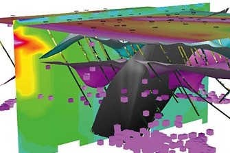
Constrained inversion models identify new resources at Ivanhoe’s Platreef deposit
Certain minerals, such as magnetite, are valued for their role as magnetic time capsules, locking-in the direction and intensity of the Earth’s magnetism at the
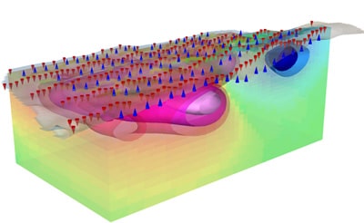
Geosoft introduces IP and resistivity inversion in VOXI Earth Modelling
Geosoft has added induced polarization (IP) and resistivity data inversion to its VOXI Earth Modelling 3D inversion software service. The new toolset is available as
Gravity and Magnetic Geophysical Methods in Oil Exploration
In an article published in E&P magazine, Henry Lyatsky, of Lyatsky Geoscience Research & Consulting Ltd. makes the case for using gravity and magnetic geophysical
Corvettes in a cave: applying geophysics to a classic car tragedy
February 12, 2014, was a tragic day for Corvette lovers around the world. Shortly after 5:30am, surveillance cameras inside the National Corvette Museum (NCM) in Bowling Green,

Magnetization Vector Inversion helps identify structures in Brazilian gold district
Magnetization Vector Inversion (MVI) helped identify structures in the Pontes e Lacerda area of southwestern Brazil, a gold district at -12° latitude where magnetic anomalies

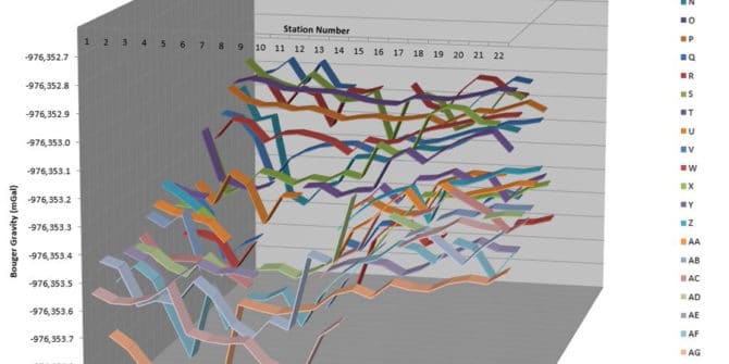
Giving seismic an uplift with gravity and magnetics
Taking the time to integrate gravity and magnetics with seismic data can pay off for oil and gas explorers with limited budgets For oil and
Targeting Exploration Mapping Needs
Industry usage of drillhole and mapping software is growing day-by-day. This is largely due to speed and efficiency advantages when dealing with greater volumes and
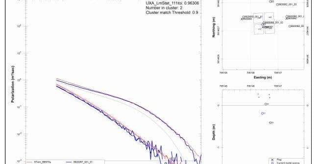
Identification and Classification of Unexploded Ordnance using Advanced Electromagnetics – A Practical Reality
SummaryIn the past differentiating between unexploded ordnance (UXO) and clutter using shape information derived from conventional electromagnetic induction (EMI) data has proven challenging. Digital geophysical