


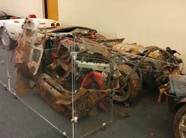
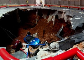
February 12, 2014, was a tragic day for Corvette lovers around the world. Shortly after 5:30am, surveillance cameras inside the National Corvette Museum (NCM) in Bowling Green, Kentucky, USA, captured stunning footage of a sinkhole opening up and swallowing eight classic Corvette cars.
Although sometimes heartbreaking and rarely recorded on video, sinkhole collapses are not uncommon in this part of south-central Kentucky. The area is known for its karst topography, characterised by sinkholes and caves formed when limestone is eroded by groundwater dissolution.The world’s longest known cave system, Mammoth Cave, is just a short drive away from the museum.
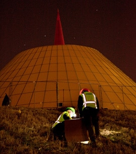
Within hours of the disaster occurring, a team of museum staff, general contractors, geotechnical and civil engineers, karst scientists, and Corvette enthusiasts had assembled onsite to survey the damage and guide the recovery.The priority was to ensure the structural integrity and safety of the NCM Skydome, the distinctive, yellow, rocket-shaped building where the collapse occurred. First, water hammer drilling was used to install micropiles for structural stabilization.
Next, environmental engineering company EnSafe was engaged to design and conduct a geophysical survey to map the extent of the collapse. EnSafe had worked with the NCM previously, providing environmental site assessments during development of the nearby Motorsports Park and racetrack, and were familiar with the geology of the area.
“News of the collapse created quite a buzz at EnSafe’s offices and as more information came in, we were already laying the groundwork for assessment strategies and potential methods for subsurface investigation,” said Nashville-based EnSafe geologist, Brian Ham, who first heard about the collapse from his colleagues in Bowling Green. Caves are both a profession and a passion for Ham who works as a professional geologist, specializing in hydrogeology and geophysics, during the week, and maps caves on the weekends.
Ham and the EnSafe team discussed the pros and cons of various geophysical methods for the job. Electrical Resistivity (ER) surveys are often used to survey karst environments. However, in this case, contiguous cable placement was impossible because of the void and buildings along the traverses, and the ER data may have been compromised by conducive metal pipes and buried wires near the surface. Seismic and ground penetrating radar, used successfully elsewhere in karst environments, were also considered but not employed. A seismic traverse directly over the void was not possible and may not have defined the voids accurately, and the high clay content in this region limits penetration of the ground penetrating radar signal to only 2-3 meters.
A microgravity survey was chosen because of the unique conditions at NCM and the method’s established success at industrial and commercial sites. However, Ham describes designing and conducting the survey on the populated and busy site as “challenging”.
“The areas near the collapse edges were inaccessible and the team had to take into consideration areas with unique cultural features, such as the HVAC supply trunk running under portions of the Skydome,” said Ham.
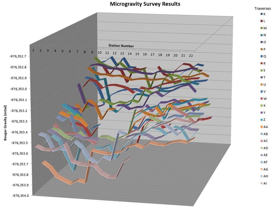
Microgravity measurements were collected at 10-foot intervals along 25 west-east traverses between 10-14 March, 2014,using a Scintrex CG-5 Autograv Microgravity Meter. The team managed little sleep during the survey. The microgravity meter is extremely sensitive to vibrations, so, because drilling and micropile installation was being conducted during the day, data collection had to be conducted at night.
Base station readings were collected before and after each traverse, along with latitude, longitude, and elevation at each station. The data were processed and corrected for instrument drift, relative changes in latitude, elevation, and slab mass using Geosoft Oasis montaj software with the Gravity and Terrain Correction extension, which Ham has been familiar with since his research days at Western Kentucky University’s (WKU) Center for Cave and Karst Studies.
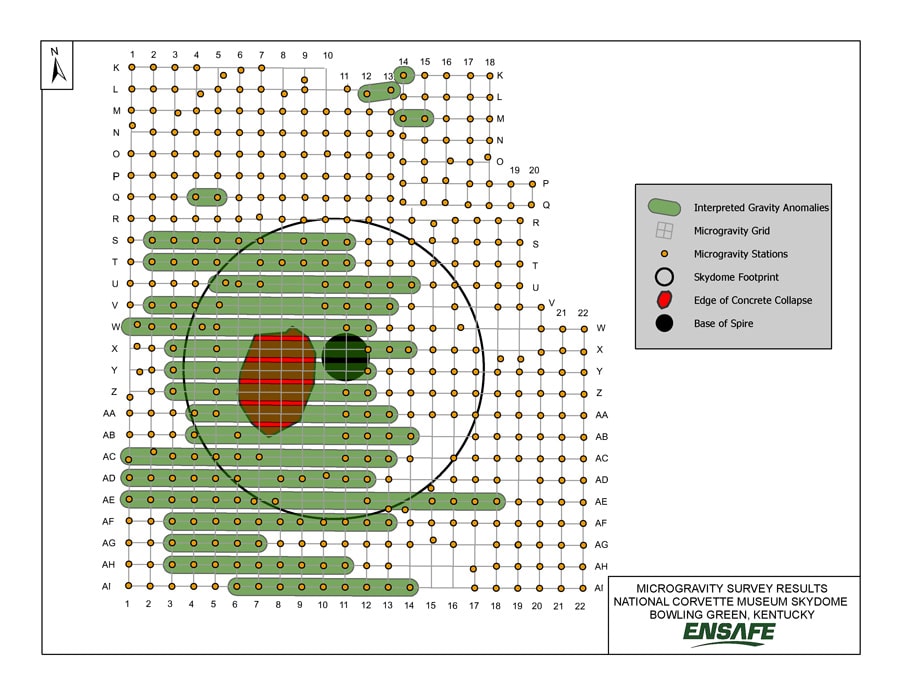
“The Geosoft software enabled an efficient data processing work flow which helped us to evaluate data in real time and make field decisions regarding the need for additional data collection,” said Ham. The microgravity data were used to prepare a map showing the general shape of the void, the concentric pile of debris directly below the collapse, and the cave passages north and south of the collapse which had intact bedrock ceilings.
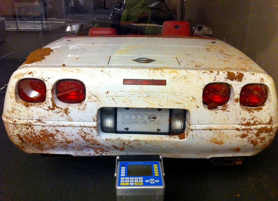
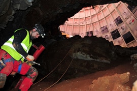
Almost one month later, on April 5, 2014, Ham joined an experienced team of cave surveyors from WKU-Dr. Jason Polk, Dr. Pat Kambesis and Kegan McClanahan – to survey the collapse and associated cave passages from within. Safety was a major consideration and by this time the Skydome was stabilized and the debris and all but one of the Corvettes had been recovered from the collapse; a 2001 Mallett Hammer Corvette Z06 – still lay covered in rock and soil.
Descending carefully into the cave, the survey team found two ‘rooms’, each about 12 meters wide by 18 meters long with a maximum height of 6 meters. Reduced to crawling on their bellies at times through narrow passages and scrambling over piles of rubble, the team mapped the cave and established survey stations at micropiles visible in the cave for georeferencing purposes.
“It was a great opportunity to inspect the geology up close and we noted a lithologic marker bed, the Corydon Ball Chert, which also helped us calibrate our geologic model, establishing elevations for the contact between the St. Louis and St. Genevieve Limestones which influences karst development in the Bowling Green area,” explains Ham.
The 2D microgravity map was combined with the high-resolution cave survey, drilling information and geologic data to create a detailed model of the collapse that was used in the geotechnical remediation of the site. There was excellent correlation between the anomalies identified via the microgravity survey and the map prepared by the cave survey team. The void below the Skydome was backfilled with aggregate supported by steel plates and micropiles with monitors installed to detect any future movement at the site.
Today, visitors to the NCM can peer into a manhole installed during the recovery and explore a new exhibit which opened two years after the initial collapse, on February 12, 2016. The exhibit tells the story of the collapse, which cars were affected, how they were recovered, what karst landscapes and caves are, how the building was fixed, and includes a map of the EnSafe microgravity results.