


Certain minerals, such as magnetite, are valued for their role as magnetic time capsules, locking-in the direction and intensity of the Earth’s magnetism at the time they were formed. This magnetic memory, called remanence, is a useful tool for dating rocks and rock sequences, but can be misleading for geophysicists modelling magnetic and gravity data.
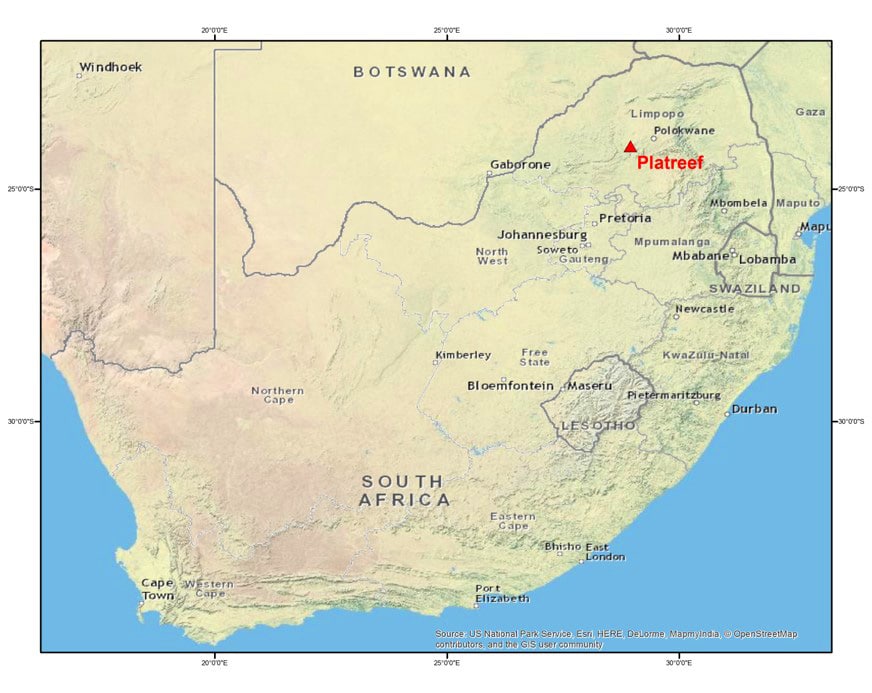
In 2010, Ivanhoe Mines requested the expertise of Barry de Wet and Nick Williams, both geophysicists with Ivanhoe Australia at the time, to help overcome this remanence problem at their flagship Platreef Project in the Bushveld Igneous Complex (BIC), 280 kilometres northeast of Johannesburg in South Africa.
The Platreef, a high-grade reef of platinum group element (PGE), nickel, copper, and gold mineralization, occurs just below a regional contact within the BIC that can be traced more than 30 kilometres along strike. Ivanhoe geologists correlate the reef with the famous Merensky and UG2 PGE reefs which account for 60% of the world’s annual PGE production.
Ivanhoe Mines had been exploring the down-dip extent of its original Platreef discovery, now known as the Flatreef Deposit, since 2007. They provided aeromagnetic data, a database of downhole physical property measurements from several hundred drill holes, and regional mapping information to de Wet and Williams, who, together with the Ivanhoe team, set out to see if the significant density and magnetic anomalism associated with the contact could be used to predict the depth of westerly extensions of the Flatreef.
“The mineralized zone, as they had defined it at that time, had flattened out at about 800 meters below the surface,” says Dr Nick Williams, Global Geophysicist for High Power Exploration (HPX), who presented this work for the first time in a keynote address to the 25th International Geophysical Conference and Exhibition in Adelaide, South Australia.
“The resolution of any potential field method, gravity or magnetics, is weak at those depths, and only capable of imaging really large, thick bodies,” says Williams, “It was critical to find ways to maximize the resolution given the weak signals that would be involved.”
A paleomagnetic solution
The solution to removing this remnant magnetization overprint and modelling the intrinsic magnetic variability of the rocks was to be found in published paleomagnetic studies that characterised the magnetic properties of the rocks in the BIC.
One of these papers was published by de Wet himself, who graduated from Pretoria University in 1972 and has been interested in finding a magnetic interpretation solution to the complexity of the Bushveld Complex magnetic signature for much of his career. In 1995, de Wet and Pretoria University’s Professor Hattingh published a study detailing how magnetic reversals were prevalent in some of the intrusive rocks in the Bushveld.
“Any predictive interpretation or modelling had to take these effects into account, but acquiring the palaeomagnetic data for all rock units in the Complex would be practically impossible,” says de Wet, who retired from his role as Chief Geophysicist at HPX in June 2016, “The only solution was to eliminate all vector magnetic effects from the magnetic data and to use those vector data to help discriminate the lithology.”
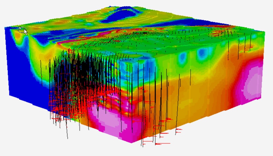
To extract the true magnetic structure of the geological units at depth, and create predictive models for exploration, they needed to integrate the standard aeromagnetic data collected over the area in 2004 with other physical property data from drill logs and the literature, such as density, velocity, conductivity and chargeability.
“Geosoft VOXI MVI was the only inversion software algorithm that we could use to do the modelling, to accommodate the high remnant magnetization we were seeing in the rocks,” says Williams.
Ivanhoe Australia and Geosoft collaborated to develop the Geosoft VOXI Magnetization Vector Inversion (MVI) software. Unlike other inversion software packages that assume rock magnetization is parallel to the Earth’s inducing field, VOXI solves for magnetization along any direction without a priori knowledge of remanence, allowing it to account for the recorded magnetic field reversals and thermochemical variations within the magnetic minerals.
Drilling success
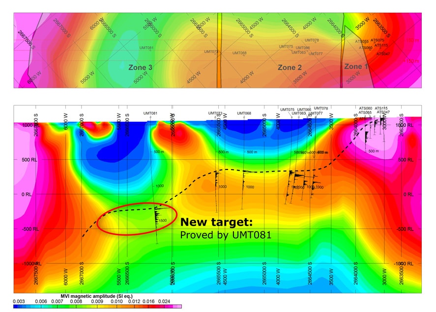
The true anomalies were identified by integrating all available datasets. The first models generated predicted a deep extension of the regional contact and Flatreef host rocks over an area of about four square kilometers, approximately 1.5 km west of the prior drilling. The target was drilled in 2011 and hit the contact and reef within 200 meters of the predicted 1300-meter depth. “Such a large step-out drill program just couldn’t be supported without robust geophysical modelling,” says Williams.
New drilling information and a FALCON airborne gravity gradiometer survey flown in 2012 were used to update the inversion models and refined the geometry of the flat-lying reef. de Wet and Williams moved from Ivanhoe Australia to HPX in 2012 and continued the Platreef work, generating three major iterations of models using Geosoft VOXI over a five-year period. Inversion models incorporating the FALCON survey identified a southerly extension to the Flatreef at relatively shallow depths, which was drilled in 2013.
“Ivanhoe Mines drilled about six holes and intersected the contact and reef within approximately 50 m of predicted depth. All of the holes intersected mineralization,” says Williams.
Ivanhoe Mines Executive VP Exploration, Dr. David Broughton, commented on the value of an integrated approach to deep exploration at Platreef: “Without the robust geophysical modeling developed by Barry and Nick, we would not have been able to predict and drill with confidence for deep extensions to the reef.”
After being awarded a Mining Right in November 2014, and submitting a positive pre-feasibility study in January 2015, construction of the No. 1 Shaft at the Platreef Project is currently underway.
Next generation geophysics
The two biggest challenges faced on the Platreef Project were relating the fine-scale physical rock property measurements to the large volumes of rock involved, and the limited resolution of the gravity and magnetic data sets at depth.
“The next generation of geophysics will be based around routine physical property logging down each and every hole just like they have been doing in the petroleum industry for decades,” says Williams. Physical property measurements, he says, are an invaluable tool for defining geophysical problems and deciding which data sets will provide the best targeting results.
Williams and de Wet are also proponents of using 3D seismic and other more powerful methods as an early exploration stage tool for better resolution at depth. Seismic and electrical methods are complementary, providing more intrinsic 3D information than gravity and magnetic data, but are more expensive and respond to different physical property variations. The geometries identified by modelling those datasets can be used to support revised gravity and magnetic modelling, which can then be used to find new targets.
“True integration requires all physical properties and drilling data on a single platform and this can only be achieved when the structure of the physical properties can be accurately modelled using appropriate geological constraints. The process becomes manageable with VOXI MVI and the Geosoft integration platform” says de Wet.