


Industry usage of drillhole and mapping software is growing day-by-day. This is largely due to speed and efficiency advantages when dealing with greater volumes and diversity of data. Exploration projects can have upwards of five hundred drillholes. As exploration projects get bigger and the number of drillholes and other datasets increase, effective software has become essential for managing and visualizing these large datasets.
Major and junior exploration companies each bring their own unique and diverse perspective to the business of exploration, however, when it comes to mapping software there is a common view on essential requirements, and emerging priorities.
With so many options available, focusing on the software functionality that you require from your exploration mapping software is considered a good strategy for maximizing efficiency and your exploration investment dollars.
Power mapping for exploration
Mark Parker, Managing Director of African Eagle Resources plc, a London AIMlisted junior exploration company operating in East Africa had a clear view of his needs when looking for mapping software, “We knew that what we needed was a good, computer- based means of archiving and visualizing our drillhole data.”
Parker has been using Geosoft’s mapping system for geophysics and geochemistry since 1990 and this past year African Eagle added Geosoft’s Target drillhole software to their system. The ability to work efficiently with all their data in one integrated environment was a key consideration.
“Our Oasis montaj system provides a powerful way of viewing and visualizing the data,” explains Parker “and it allows you to combine different data sets, in different ways, to make the best use of all the data you have available.”
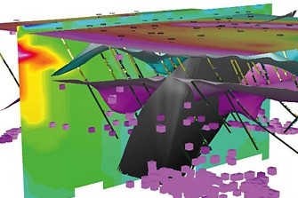
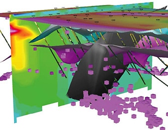
Visualization has played a critical role in African Eagle’s exploration projects. “In a situation where you don’t have any outcrop, which is typical in Tanzania, you’re relying very much on your drillholes to do basic geological mapping, as well as actual mineralization interpretation,” says Parker. “In this case, it’s quite important that you have powerful tools for visualization which allow you to make the best use of the data you have and to interpret the data to the maximum.”
Integration with their Geographic Information System (GIS) environment has become a greater priority for African Eagle. In addition to meeting internal needs, GIS integration allows data to be shared effectively with African Eagle’s major exploration partners.
Exploration projects often involve two or more companies working together within joint ventures, option agreements and other partnership arrangements. “As an example the partner on one of African Eagles’ Tanzania projects uses ArcView,” explains Parker. “In working with them, we need to supply formats that can be viewed in ArcGIS. If we can supply things in native ArcGIS so much the better.”
Parker sees the market introduction of Geosoft’s Target for ArcGIS, a drillhole and mapping extension for ESRI’s ArcGIS, as a positive step towards meeting their integration needs. “Target for ArcGIS will allow us to exchange our data, and particularly our visualizations, as freely as possible with ArcGIS users.”
Exploring in GIS
Julian Misiewicz, Consulting Geologist for Africa and Europe with Gold Fields International, a South Africa-based major global gold producer makes a distinction between essential and specialist-use mapping functionality.
“In exploration, you need three basics: database software, a GIS package, and, definitely, a drillhole processing package,” says Misiewicz. “All three are essential.” Having met those needs, if cost is not a factor, specialized three dimensional modeling packages are also very beneficial.
Gold Fields uses ArcGIS as its GIS platform for exploration. Recently, they purchased Geosoft’s Target for ArcGIS for its ability to provide integrated drillhole plotting and surface mapping capabilities in ArcGIS. “ArcGIS is an outstanding package”, says Misiewicz, “and Target provides the facility to plot drillholes within ArcGIS.”
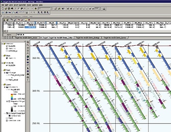
Using Target for ArcGIS drillhole mapping software is quick and easy. It provides the facility for drillhole plotting, as well as surface mapping, contouring, plotting and treatment of geochemical and geophysical data in ArcGIS. One doesn’t have to be a specialist or geophysicist to process the data, and a geologist working with multiple data sets can do it easily using Target within ArcView.
Efficiency in data processing is important, but ultimately the proof, and the power, is in seeing your data. “The better you can see and plot your data,” says Misiewicz, “the better you are able to understand it, firstly, and the better you are able to get the best value out of that data, and to use it effectively throughout the business environment.”
For many years, specialized exploration software, such as Geosoft’s Oasis montaj has provided the ability to expertly visualize geophysical, geochemical and geological data within an integrated environment. “One of the things that Geosoft has been very good at, is visualization,” says Misiewicz. “Oasis montaj is an excellent package for creating beautiful images of geophysical and geochemical data.”
Visualization technology has come a long way. Advanced rendering techniques together with three dimensional modeling applications have added a lot of power to the way you can view and interpret your data.
Until recently, however, visualization tools for exploration data in the GIS environment have been very limited. This is rapidly changing, as integration of exploration software with broad-based GIS systems takes greater priority in the industry. Target, as an extension to ArcView, is seen as providing a necessary solution.
Using Target, geologists are able to bring in a borehole, and plot the trace of that borehole directly on their map. They can also plot sections straight out of their ArcGIS package, and are able to incorporate all the information they have in their GIS package, the geological mapping, the geophysics images and the geochemistry in particular, in their interpretations.
New exploration software is tasked with meeting the growing need for seamless integration of exploration datasets within the broad-based GIS environment, while continuing to meet the rigorous mapping and processing requirements of geological users.
At the end of the day, explorationists use computerized methods because it’s quicker and better than doing it by hand. The key advantage that exploration drillhole and mapping software, such as Target and Target for ArcGIS, bring is the capability to handle large volumes of data and visualize a thousand or more drillholes at a time, allowing geologists to create and revise maps and sections quickly and easily, while formulating and fine-tuning their understanding of their targets.