


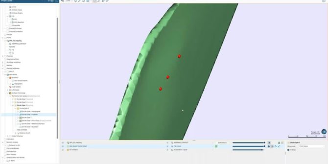
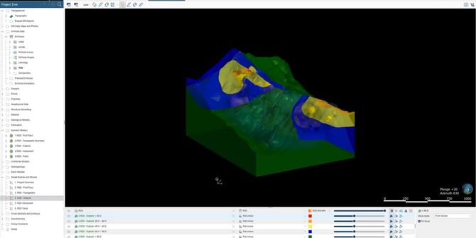
Leapfrog Geo vein modelling best practices
This session takes a deeper look at how Leapfrog Geo constructs a vein system in order to build upon and provide a better understanding of
Taming the complexities of contaminated sites
This webinar covers: Bringing teams and diverse technical expertise together to see the full picture and build a collaborative solution. Discovering where the contamination lies
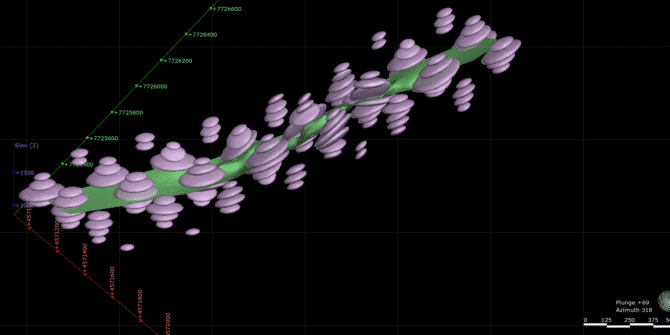
Using Leapfrog Edge to Automate Internal Resource Estimation Reviews at the Alpala Porphyry Copper-Gold Deposit, Cascabel Project, Northern Ecuador
The Project SolGold plc (SolGold) is a leading exploration company focused on the discovery, definition and development of world class copper-gold deposits. In 2018,
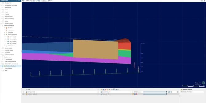
Troubleshooting with structural trends
Leapfrog has useful tools to enable you to apply structural trends to your modelling. Applying a structural trend can be great in helping to reflect
Data Management: Mx Deposit Demonstration
Learn about drilling and sampling workflows in MX Deposit, a cloud-hosted web application
Numeric Modelling RQD data and Evaluating onto Mine Designs
Benefits Rapidly visualise and analyse geotechnical numeric data; Powerful prediction tool for Mining Engineers; Increased/optimised communication of geotechnical data for design purposes; Enhanced connectivity between
Cross Sections from Leapfrog to GeoStudio
Benefits Easily utilise your 3D geological models from Leapfrog to define your 2D geometry for your analysis in Geostudio Save time without needing to define
UXO Target Analysis
Target Analysis Creating and editing target polygons Model targets for depth Duration 9 min JTNDJTIxLS0lMjBUaGUlMjBzY3JpcHQlMjB0YWclMjBzaG91bGQlMjBsaXZlJTIwaW4lMjB0aGUlMjBoZWFkJTIwb2YlMjB5b3VyJTIwcGFnZSUyMGlmJTIwYXQlMjBhbGwlMjBwb3NzaWJsZSUyMC0tJTNFJTBBJTNDc2NyaXB0JTIwdHlwZSUzRCUyMnRleHQlMkZqYXZhc2NyaXB0JTIyJTIwYXN5bmMlMjBzcmMlM0QlMjJodHRwcyUzQSUyRiUyRnBsYXkudmlkeWFyZC5jb20lMkZlbWJlZCUyRnY0LmpzJTIyJTNFJTNDJTJGc2NyaXB0JTNFJTBBJTBBJTNDJTIxLS0lMjBQdXQlMjB0aGlzJTIwd2hlcmV2ZXIlMjB5b3UlMjB3b3VsZCUyMGxpa2UlMjB5b3VyJTIwcGxheWVyJTIwdG8lMjBhcHBlYXIlMjAtLSUzRSUwQSUzQ2ltZyUwQSUyMCUyMHN0eWxlJTNEJTIyd2lkdGglM0ElMjAxMDAlMjUlM0IlMjBtYXJnaW4lM0ElMjBhdXRvJTNCJTIwZGlzcGxheSUzQSUyMGJsb2NrJTNCJTIyJTBBJTIwJTIwY2xhc3MlM0QlMjJ2aWR5YXJkLXBsYXllci1lbWJlZCUyMiUwQSUyMCUyMHNyYyUzRCUyMmh0dHBzJTNBJTJGJTJGcGxheS52aWR5YXJkLmNvbSUyRmJxdHBUOVk0d3RMZUFTeGZya1oxR0cuanBnJTIyJTBBJTIwJTIwZGF0YS11dWlkJTNEJTIyYnF0cFQ5WTR3dExlQVN4ZnJrWjFHRyUyMiUwQSUyMCUyMGRhdGEtdiUzRCUyMjQlMjIlMEElMjAlMjBkYXRhLXR5cGUlM0QlMjJpbmxpbmUlMjIlMEElMkYlM0UlMEElMEE= Video Transcript The video transcript gets copy and pasted here