



By Colleen O’Hanlon, Corporate Content Lead
In the city of Maceió, Brazil, decades of underground rock-salt mining left a hidden and hazardous legacy: 35 vast subterranean cavities.
When the ground began to shift and crack, posing a direct threat to the city’s one million inhabitants, the Geological Survey of Brazil (SGB) was called in to urgently assess the risk.
Using Leapfrog, the SGB developed a comprehensive 3D geological model that provided critical insights into the subsurface instability, enabling authorities to take decisive action and avert what would become the largest ongoing urban social-environmental disaster in Brazil.
The challenge: a city on unstable ground
Since the 1970s, extensive salt mining operations beneath Maceió had created enormous underground voids, some up to 150 metres in length. For years, these cavities were a known but unquantified risk. The situation reached a crisis point in 2018, when a seismic tremor triggered widespread surface cracking and significant ground subsidence in several neighbourhoods.
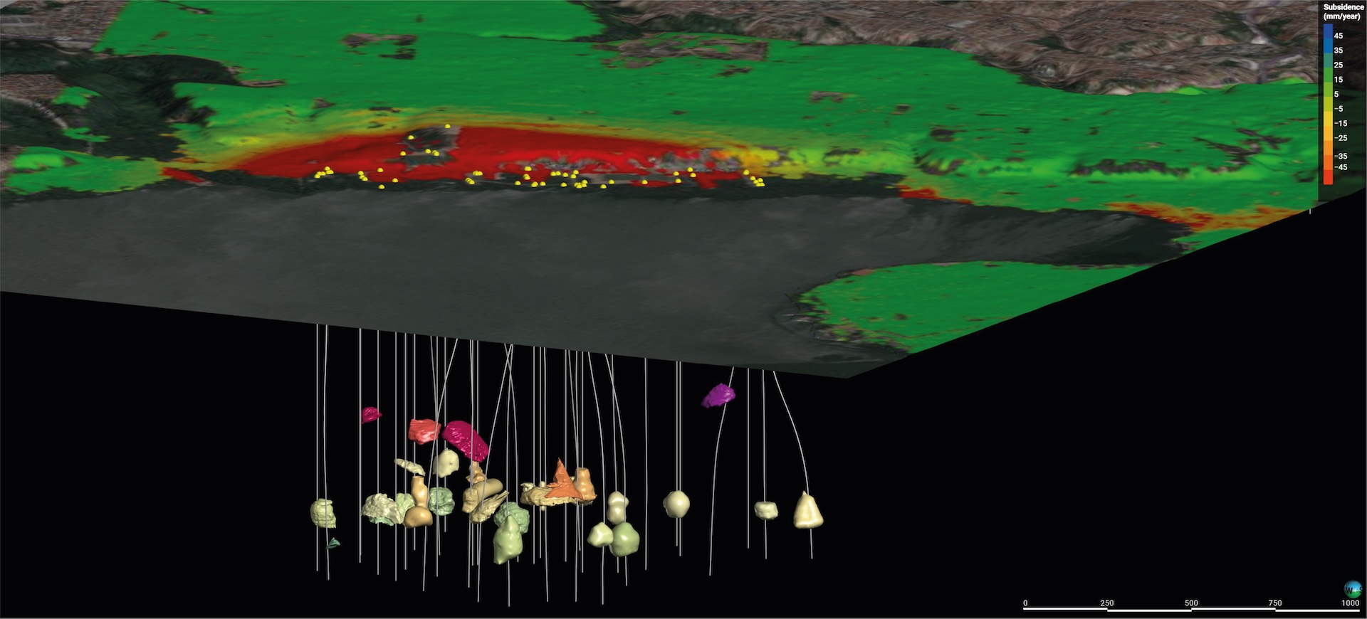
The subsidence map shows that the areas most affected by the lowering of the ground are positioned exactly over the cavities produced by salt mining. The subsidence recorded in these areas is greater than 45 mm per year.
The stability of the ground was compromised, threatening homes, streets, and vital infrastructure. A serious social problem unfolded as areas were evacuated. The SGB faced the immense challenge of understanding the complex subsurface geology and the behaviour of the salt mines to determine the cause of the instability and predict the future risk to the city.
The solution: visualising the subsurface with Leapfrog
To tackle the problem, the SGB needed a tool that could integrate diverse datasets – including cartographic, geological, and geophysical surveys – into a single, coherent model. While initial attempts with other software proved inadequate for creating an accurate stratigraphic model, Leapfrog’s implicit modelling capabilities proved to be the ideal solution.
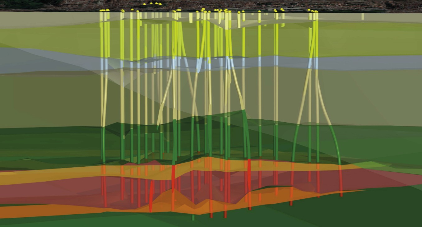
This is a three-dimensional geological model where the evaporite (salt) layer has been highlighted. The model has been constructed using boreholes that were designed for salt mining purposes.
The project team developed a groundbreaking methodology to build a 3D model of the salt-mine cavities. They used historical sonar survey data, georeferencing the images within Leapfrog. By digitising cross-sections from multiple angles, they constructed 127 detailed 3D solids representing each salt mine.
Leapfrog was also instrumental in modelling the area’s broader geology. Its implicit modelling algorithm enabled the team to accurately map the stratified layers of the Alagoas Basin and identify pre-existing rupture structures that intersected with the salt mines. This integrated 3D model, combining the mine cavities and the regional geology, became the cornerstone of the investigation.
Although developed in response to an unfolding crisis, the model also demonstrates the broader role that 3D geological modelling can play in responsible mining: helping organisations understand subsurface risk, support transparent decision-making, and inform safer closure and remediation strategies.
Related content:
* From hype to impact: Seequent’s perspective on MCP, vibe coding and the future of AI in geoscience
* Data-rich, insight poor? It’s time to tame your geotechnical data chaos
* Co-operation essential for tackling landslide dangers
* How AI-driven subsurface insight is shaping infrastructure outcomes
The outcome: data-driven decisions that saved lives
The 3D model provided unprecedented insight into the disaster unfolding beneath Maceió. Key findings included:
- Understanding the cause: The model visualised how instabilities in the cavity roofs were causing them to collapse and rise towards the surface. Vertical displacements of up to 350 metres were measured, with some cavities expanding by as much as 200%.
- Identifying critical risks: The analysis revealed that cavities were breaking through the salt layer and connecting with each other, dramatically increasing the risk of catastrophic sinkholes. One mine collapse in late 2023 created a crater of approximately 27.5 million cubic metres – and released salt directly into the Mundaú Lagoon, devastating the ecosystem that thousands of local families depended on for fishing and shellfish harvesting.
- Informing evacuation and compensation: The findings provided the scientific evidence needed to isolate the most vulnerable areas. This led to the permanent condemnation of approximately 14,000 properties and the forced displacement of around 60,000 people. The study also formed a solid basis for the affected population to demand financial compensation.
- Creating a digital foundation: The model now serves as a crucial tool for monitoring soil stability and can be the foundation for a future digital twin approach for the area, allowing for more accurate and dynamic decision-making to protect the local population.
By leveraging Leapfrog, the Geological Survey of Brazil successfully transformed complex data into a clear and actionable 3D model. This enabled them to understand the root causes of the subsidence, mitigate the impact of the disaster, and safeguard the lives of tens of thousands of people through ongoing recovery efforts led by the United Nations Office for Project Services (UNOPS).
The model provides a powerful example of how integrated subsurface data can support better decisions, not only as a response but as a preventative measure. By making hidden subsurface conditions visible, 3D geological modelling can help identify instability earlier, guide monitoring strategies, and reduce the likelihood of downstream impacts before they occur.