


Streamlining Site Investigation: Realizing the Benefits of Cloud-Based Geotechnical Data Management
While cloud technology continues to redefine business workflows and present growth opportunities across a range of industries, the benefits of cloud-connected geotechnical data management still
Connected Workflows for Geotechnical Projects in Transportation
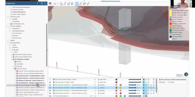
This webinar was originally presented on May 16, 2022 through the American Society of Civil Engineers (ASCE). What you’ll see: 2D and 3D finite element
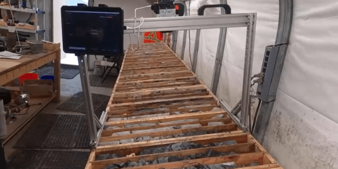
MX Deposit & Imago logging and capture in action
and to make more accurate ore/waste decisions in mining. See how MX Deposit and Imago are used in the field by Freegold Ventures Limited do
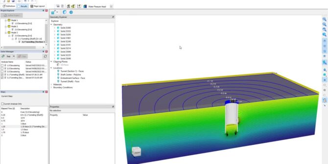
Mastering 3D Analysis: Groundwater Flow in Shaft and Tunnel Design
Shafts and tunnels are critical for the construction and operation of mining, transportation, and sanitation facilities. The design of these shafts and tunnels hinges on
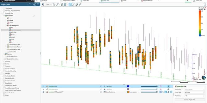
How to handle CPT data in Leapfrog Works: Soil Characterisation Using CPT Data
Watch as Customer Solutions Specialist - Geotechnical, Sudur Roy, guides you through the calculation tool of Leapfrog Works. In the first part of the mini-series
Green fuel from green power: How geothermal can produce hydrogen
Hydrogen is a hot commodity in the energy transition. It can be used in fuel cells for cars or blended for home heating. However, it
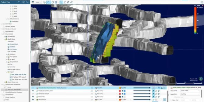
Striking gold sustainably in South Dakota’s famous Black Hills
Working within a National Forest, they’re using non-invasive exploration techniques and software to create a sustainability plan beyond prospecting – to production and reclamation. Overview
Enhanced Proportional Weighted Reports in Leapfrog Edge 2021.2
In this video, Ryan Lee, Product Manager for Production Geology goes into more detail. Overview SpeakersRyan Lee Product Manager, Production Geology - SeequentDuration3 minJTNDJTIxLS0lMjBUaGUlMjBzY3JpcHQlMjB0YWclMjBzaG91bGQlMjBsaXZlJTIwaW4lMjB0aGUlMjBoZWFkJTIwb2YlMjB5b3VyJTIwcGFnZSUyMGlmJTIwYXQlMjBhbGwlMjBwb3NzaWJsZSUyMC0tJTNFJTBBJTNDc2NyaXB0JTIwdHlwZSUzRCUyMnRleHQlMkZqYXZhc2NyaXB0JTIyJTIwYXN5bmMlMjBzcmMlM0QlMjJodHRwcyUzQSUyRiUyRnBsYXkudmlkeWFyZC5jb20lMkZlbWJlZCUyRnY0LmpzJTIyJTNFJTNDJTJGc2NyaXB0JTNFJTBBJTBBJTNDJTIxLS0lMjBQdXQlMjB0aGlzJTIwd2hlcmV2ZXIlMjB5b3UlMjB3b3VsZCUyMGxpa2UlMjB5b3VyJTIwcGxheWVyJTIwdG8lMjBhcHBlYXIlMjAtLSUzRSUwQSUzQ2ltZyUwQSUyMCUyMHN0eWxlJTNEJTIyd2lkdGglM0ElMjAxMDAlMjUlM0IlMjBtYXJnaW4lM0ElMjBhdXRvJTNCJTIwZGlzcGxheSUzQSUyMGJsb2NrJTNCJTIyJTBBJTIwJTIwY2xhc3MlM0QlMjJ2aWR5YXJkLXBsYXllci1lbWJlZCUyMiUwQSUyMCUyMHNyYyUzRCUyMmh0dHBzJTNBJTJGJTJGcGxheS52aWR5YXJkLmNvbSUyRjhUeldYbWhBbkJaVEhXeHg0RkJHTWUuanBnJTIyJTBBJTIwJTIwZGF0YS11dWlkJTNEJTIyOFR6V1htaEFuQlpUSFd4eDRGQkdNZSUyMiUwQSUyMCUyMGRhdGEtdiUzRCUyMjQlMjIlMEElMjAlMjBkYXRhLXR5cGUlM0QlMjJpbmxpbmUlMjIlMEElMkYlM0UlMEE= Video