


Intro: Joanne Demmer shares some of the challenges in her role as a geophysicist and how a data-driven collaborative approach can better support exploration success.
Geophysicists are expected to help answer some big questions in exploration.
What does the geology look like? How about its history? What are the constraints? What quality and quantity of mineralisation can we expect? How soon and at what cost?
“We need to confidently understand what is beneath the surface so we can answer these critical questions and move to the next step faster,” says Joanne Demmer, Project Geophysicist at Seequent.
Across any exploration project, valuable data is constantly being collected in many ways, by multiple stakeholders, such as exploration geologists, managers, geophysicists or external consultants.
But what can hinder exploration is relying on disconnected solutions that require a labour-intensive workflow to share and collaborate data and results.
“Our challenge is to quickly and accurately combine all exploration findings to get a clearer understanding of the story behind each unique environment we’re working in,” says Joanne.
“And how to effectively communicate this to everyone involved with the project.”
A powerful, fast, agile workflow that saves time, reduces risk, and speeds up critical, strategic planning – can help.
Get more value out of data sets
From Quality Assurance to Quality Control, there is so much that needs to happen across an exploration workflow to ensure you’re on the right track.
For example, checking that data is within specifications during a survey or a scope of work, migrating other data (such as geological drilling data) accurately or understanding chemical data with respect to geophysics data.
“Collating and assessing data from multiple sources and ensuring you have everything required to inform stakeholders, can be challenging,” says Joanne.
“If these challenges are not met in a timely way, then teams have to wait longer for feedback, meaning they can’t get started on a project or may demobilise too soon,” she adds.
From data importing and powerful processing, to 3D visualisation and faster decision-making, sharing the latest information and ideas across teams – in near real-time – is imperative.
And this is where innovative solutions that integrate the complex steps in this workflow shine.
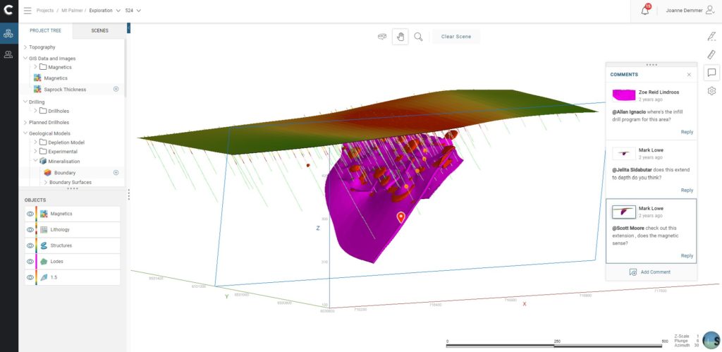
“Being able to integrate, interpret and communicate all your geoscience data with rapid, dynamic 3D modelling is key,” says Joanne.
“Allowing you to provide specific, relevant, and continually updated analyses that strengthen the economic accuracy of your exploration project.”
Push the boundaries of your data
A good workflow also means various teams involved across an exploration project can draw on different stages of the value chain, at very specific points in time.
“The freedom to work outside a limiting linear timeline gives you the flexibility to go back to the beginning, jump forward to the present, or pinpoint an exact spot in your exploration programme,” says Joanne.
This allows all the different scientists involved – from geochemists to geophysicists, or structural geologists to mineralogists – to easily provide their unique input, or test various models and hypotheses throughout.
“Meaning everyone can take a deep dive into how their data affects each exploration stage,” says Joanne. “And push the boundaries of that data to get the most insights and highest value possible.”
It’s also important that the major stakeholders, such as an exploration manager, can easily audit and check the validity of results throughout.
“That could mean going back to the raw data, checking or testing the process stage, or looking at the enhanced stage 3D visualisations to better refine and highlight target features,” says Joanne.
“Or go back through different parts of the value chain to see how to take the right steps towards replicating what processing or enhancements worked,” she adds. “And all saved in one place and trackable.”
Easily get a fresh set of eyes on a project
Giving all stakeholders instant access to prior, existing knowledge to quickly build on, is a huge value add.
“If a project is in a space where it can be easily accessed and understood, then anyone can hit the ground running the moment they join the project,” says Joanne.
“You might be working on a totally different tenement or in a totally different area, but the value of a good workflow equates to being able to jump in, quickly get started, and provide your own insights and feedback immediately,” she says.
But what about solving the challenge of version control in a continuously changing exploration data environment?
“Version control can be a nightmare,” says Joanne. “Too many data file types, names or suffixes, or perhaps limited access to an entire project kept in one person’s computer – and if this person moves on – so too does all that knowledge.”
“Data, if not backed up correctly can be over-written or data stored on USB can degrade over time,” she adds. “These risks pose a threat to data security and longevity, which is important for auditing and government reporting reasons.”
Dynamically updated 3D versions, securely saved in a cloud-based space, are easily accessible to all the various stakeholders and show who’s been notified of the changes as well.
“Now we can easily see what decisions have been made, based on what, by who and when,” says Joanne. “And either get a fresh perspective on the target or try to replicate that exploration success in new tenements.”
“A connected workflow also gives a better understanding of which geophysical techniques give the best insight into a particular deposit type,” says Joanne. “And this thorough analysis can help drive future exploration efficiency.”