


The Stephenson Avenue Extension in Perth, Western Australia will bring improved traffic flow, better connectivity, and increased capacity. But investigations into site conditions showed varying ground settlement rates were a major roadblock.
How did a WSP geotechnical engineering team find the right ground improvement solution from more than 160 different design combinations? Using the fast, efficient automation capability of PLAXIS together with Python.
The $165 million Stephenson Avenue phase 2 extension is a large, complex road infrastructure project currently underway in Perth, Western Australia.
The extension includes a traffic bridge that crosses the busy Mitchell Freeway (built in the early 1980s) with site ground improvement due for completion in 2024.
Data collected by InSAR over a six-year period up to 2020 revealed that although the freeway was built 40 years ago, the site at the proposed road extension is still settling at varying rates of up to a few millimetres a year.
Sand-capped, highly compressible peat swamp soil underlain by a thick sand stratum makes ground conditions challenging.
“If the approach embankments and bridge ramps were built without ground improvement, the peat would continue to settle significantly,” says Shan Tom Wong, Principal Geotechnical Engineer at WSP Australia.
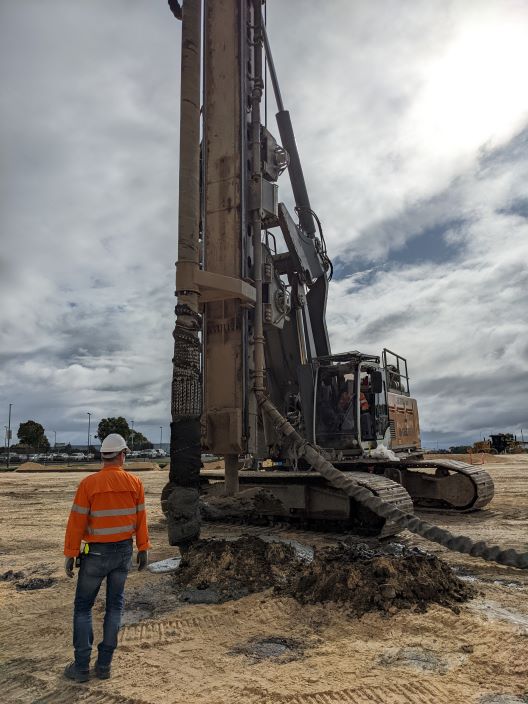
Controlled Modulus Column (CMC) is a ground improvement method that reinforces the soil with a network of concrete columns (Image credit: WSP)
Easily and efficiently model multiple scenarios
WSP provides world-leading professional engineering and design services across multiple industry sectors, including transportation and infrastructure.
Shan Tom is part of the geotechnical team led by WSP’s Technical Executive, Simon Tan, working on design delivery for this key transportation infrastructure project.
The team selected the ground improvement method of installing concrete columns through to the competent stratum below the peat layer. Three crucial design variables – peat thickness, embankment height, and concrete column spacing – resulted in a whopping 160 design combinations to be analysed.
“It would be a huge task to build this many models one by one, and any error or oversight would each need to be refined or corrected,” says Simon.
“We decided to use the fast and efficient automation capability of PLAXIS together with Python.”
Part of Seequent’s world-leading geotechnical suite, PLAXIS innovative 2D and 3D modelling software enables you to design and perform advanced finite element soil and rock deformation analysis.
After a few iterations to polish the Python code, the PLAXIS analyses could be automated to easily and efficiently model all 160 different design combinations.
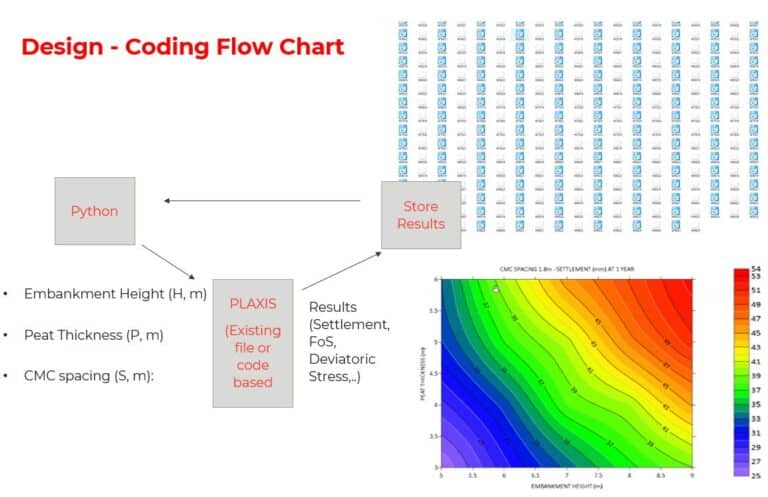
Design flow chart showing the automised analysis of axisymmetric Controlled Modulus Column with PLAXIS models by Python Programming (Image Credit: WSP)
The beauty of this algorithm? Simplicity
As projects progress and new information lands, geotechnical engineers can often get bogged down in repetitive design tasks or tediously revisiting design models to make tiny adjustments.
“Where one or a few changes have impacted many models, the use of PLAXIS with Python to find a ground improvement solution helped save time and cost,” says Shan Tom.
The team started with a 2D axisymmetric numerical model in PLAXIS. They then pulled on the expertise of their Brisbane-based WSP colleague, Douglas Tun, Associate Geotechnical Engineer, for Python coding.
Douglas used the Python wrapper for the PLAXIS API (Application Programming Interface), which is delivered as part of the PLAXIS program.
His prior doctoral studies included developing a series of Artificial Intelligence and Optimisation Algorithms for geotechnical design. One simple and efficient optimisation tool was the Linear Search or Brute Force Algorithm.
“The algorithm works by finding a specific element in an array or list and checking each element in sequence until the target element is found or until the end of the array is reached,” says Douglas.
“It’s very simple and easy to understand and importantly, it’s reliable – it always works,” he says.
See how WSP efficiently designed the right ground improvement solution using PLAXIS with Python with this 1-minute video.
Optimise your design using PLAXIS with Python
Construction of the freeway extension has continued in full swing with approximately 80% of the concrete columns installed by mid-2023.
“As peat has significant long-term creep settlement, the compressible layer was modelled using the soft soil creep model,” says Simon.
Five and forty-year estimated settlements were output into data files for graph plotting.
The exercise involved the analysis of 160 axisymmetric models, storage of data files, and graph plotting that were all automated to enable visualisation and easy interpretation of the results.
“Selecting suitable preliminary column spacings in 3D models would be very time-consuming,” says Simon. “So, the preliminary decision was based on the 2D settlement graphs before more detailed analyses using PLAXIS 3D were conducted.”
“The 3D model includes additional elements, such as a retaining wall, to simulate lateral movements of the ground and wall over time.”
PLAXIS with Python is efficient, cost-effective, and has great visualisations for deliverables.
The WSP geotechnical team agrees using PLAXIS together with Python could have many other potential applications, especially in the repetitive design tasks space, to help save time and cost across infrastructure projects.