Section tools in Leapfrog are a powerful way to interrogate modelled data while maintaining a dynamic workflow. With this new release, we have made significant improvements to our section tools including:
- Streamlining the workflow to create new section layouts.
- Projecting new objects onto section layouts.
- Improvements in horizontal sections to generate site and section location plans.
- Introducing the new Longitudinal section tool.
Streamlined workflow
In the latest version of Leapfrog, you can now add objects directly in the section layout editor. There is no longer the requirement to first evaluate the object in the project tree and then add the object in the layout. This has streamlined the process of creating section layouts and by-passes the need to set the page size and add evaluations before getting into the section layout editor.
Furthermore, it is now easier to evaluate surfaces and models onto the section through a single dialogue in the project tree. We have made this clear distinction between evaluating on a section, for export as a design or to see in the scene and creating a section layout, with the aim to make the different workflows and tasks more intuitive.
New projections
Projecting boreholes is required to show observational data alongside your model interpretation, for this release we have extended projections to points, lines, and structural data, so that they too can now be projected onto a section layout. In addition, it is now possible to add filtered subsets of interval tables onto the section layout and apply different styling to each subset.
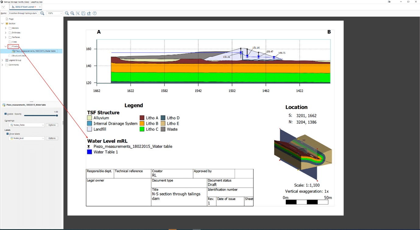
Points
A new folder has been added to the section layout editor so that all point tables in Leapfrog including downhole, GIS and geophysical, can now be projected. One such workflow that is now possible is the ability to display water level measurements alongside piezometric surfaces built in Leapfrog. In addition, by utilising styling options, labels and query filters, multiple ground water level measurements recorded on separate occasions can be displayed on the same section layout.
We also envisage that the following data types are now easier to communicate through section layouts:
- Laboratory test data results.
- Cross section through an aerial survey point cloud coloured by height banding.
- A subset of downhole CPT results.
Lines
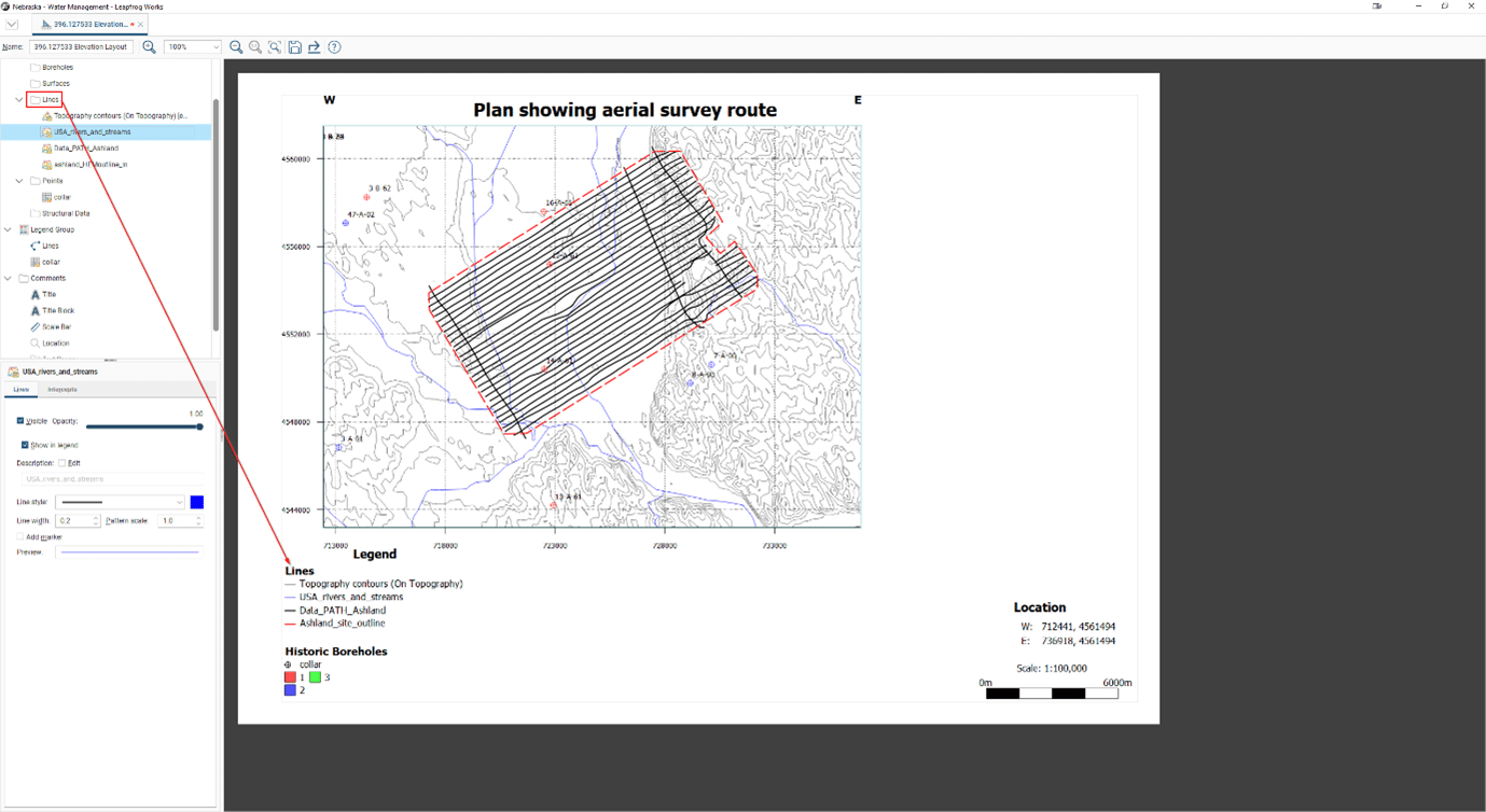
We have now added functionality which enables you to project lines, this means you are no longer limited to just displaying where lines intercept the cross section. Now it is possible to project the whole alignment, GIS, design, or polyline on to a section layout from a distance or clip the projection, by a set distance from the section. Once the line has been projected it is now possible to change the line style, width and colour with the same options as a surface evaluation.
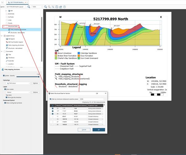
Structural Data
As with points a new folder has been added to the section layout tab so that structural data tables can be projected onto the section layout. The projection type can either be “along plane distance” where the structural disk is projected to the point where the plane of the structural disk intersects the plane of the section or “closest distance” where the structural disk is projected along the closest vector to the section. It is likely that the “closest distance” projection type will be used predominantly with downhole structural measurements to indicate variation downhole while the “along plane distance” will be used to visualise the structural data in its geological setting. Different joint sets can be displayed either by colouring by category column or by utilising query filters to add multiple subset of a structural data table.
For overturned measurements, which are structural disks with negative polarity in the scene, an overturned symbol is automatically drawn, this can be turned off by toggling an option in the properties.
Combining the new evaluation types into a Plan
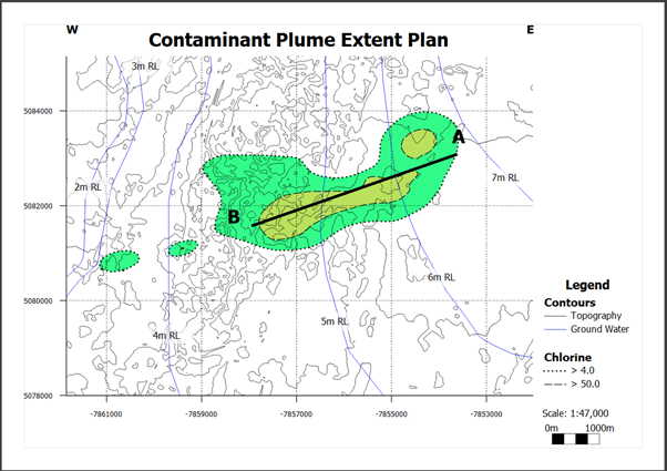
The combination of the new projection methods opens the possibility of generating basic site or section location plans by creating a horizontal section. Imported GIS line data can be projected as lines and collar locations as points with the hole ID as a label. Unfortunately, we were unable to add contours as a projectable line type in this release so at present contours created in Leapfrog will need to be exported and then reimported to be able to be projected. We plan to allow contours to be evaluated onto section layouts in a future release.
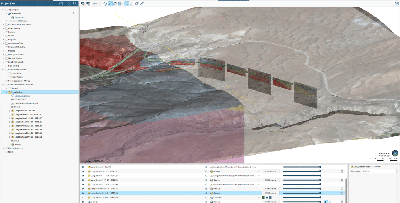
Long sections are the new fence sections
With a new name comes additional functionality. Long sections now allow you to choose where on the input polyline, GIS line, alignment or design line the long section starts and ends. This means creating long sections along linear structures (such as road, rail or pipeline infrastructure projects), which generally have large project extent to depth ratios are now easier to create so they fit on a single page with a realistic scale. The requirement to ‘massage’ the section layout is consigned to the past.
To go alongside the above we have implemented the concept of child sections following the fine example set by the Alignment Serial Sections. This means that now a long section can be created using multiple lines, such as predefined position of sections through a specific structure (i.e tailings dam or excavated faces) or automatically subdivide a line which then creates a child section for each segment at specified chainage intervals. Master section layouts can be created and linked to a specific child section with the layout settings dynamically applied and updated when changes are made. Each individual child section can have its own section layout that can be copied to other sections.