


The Workbench Airborne FEM extension is a comprehensive solution for importing, processing, and inverting data from airborne systems like Resolve. It supports a wide range of coil configurations and streamlines adding system information during data import. Integrated with the GIS interface, this extension provides an easy workflow from raw data to results, including quality control and inspection of inversion results. Modelling and presentation capabilities are provided by the well-established functions of Workbench, making it easy to integrate with boreholes, create reports, and more.
Save your time for interpretation
Key features
- Flexible and easy-to-use importer that supports various airborne frequency system setups
- Advanced processing tools with automatic data filtering
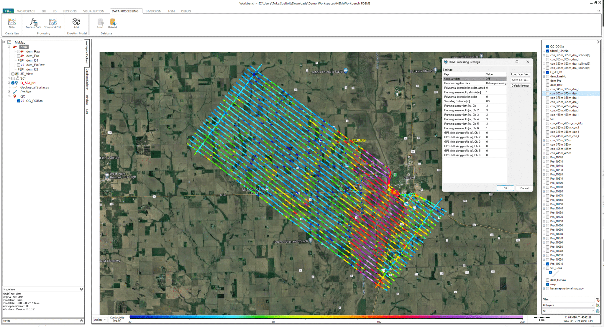
- GIS interface integration
- Automated LCI/SCI data inversion
- Visualisation of data and inverted models on the GIS and cross-sections
- Integrated QC tool
Data in xyz format can be imported with the following information:
- Data in ppm
- UTM coordinates
- Coil configuration
- Coil distances and coil altitudes
- Instrument frequencies
For each coil configuration, you can add both relative and absolute standard deviations. Column mapping is performed with a mapping editor and both data mapping and system information can be saved or loaded in the importer.
Processing & inversion
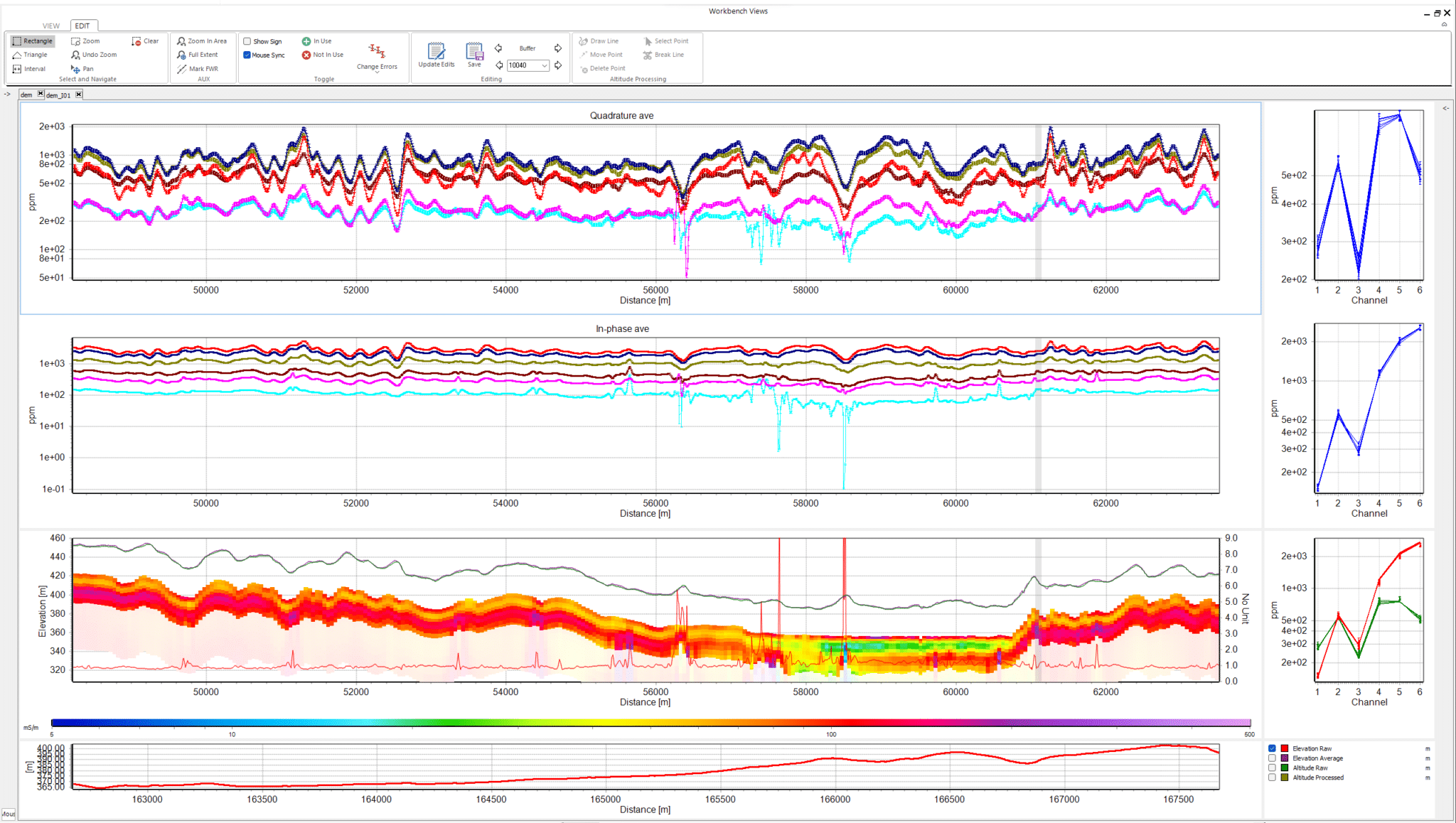
The extension features two noise suppression algorithms, offering both automatic and custom settings. A GPS shift can be applied to ensure the data points are aligned with the horizontal focus point of the given transmitter-receiver coil configuration. The processing window facilitates comparison between raw and processed data for each channel and supports the removal, editing, and plotting of individual soundings. Its direct link to the GIS interface simplifies the location and processing of data points.
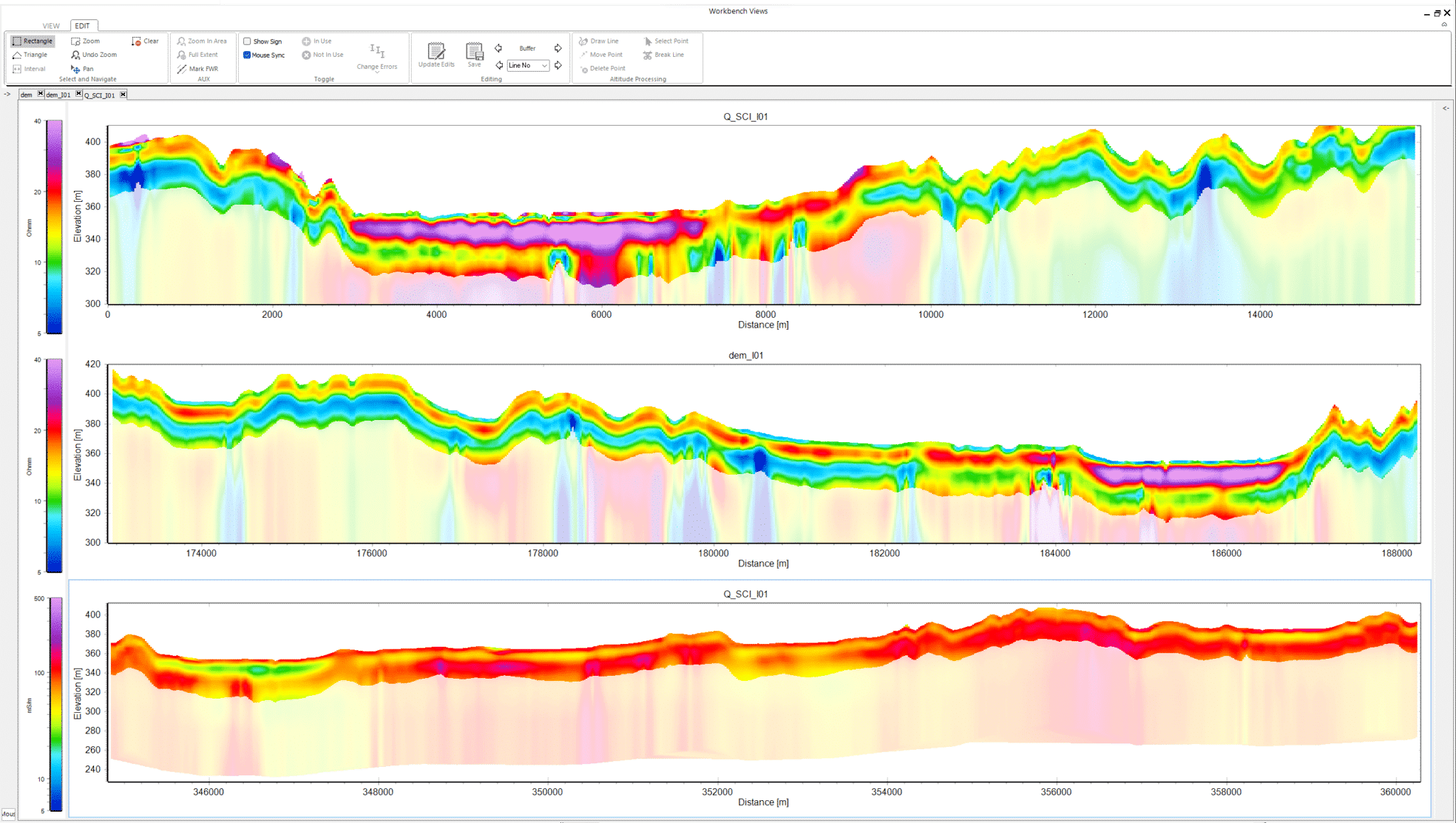
Utilising the AarhusInv inversion code, airborne FEM data can be inverted with layered, smooth, or sharp model setups, as LCI or SCI, along with a Depth Of Investigation (DOI) calculation.
Inversion results and quality check
Easily inspect the quality of the inversion models to identify trusted areas and those requiring further processing. Very importantly, a depth of investigation is calculated for each sounding, precisely indicating how deep the models are trustworthy.
Different themes can be created to show the inversion results, e.g., resistivity themes or a layer search to visualize depth to a layer with certain conditions. Profiles can be drawn on the GIS interface, with the ability to add boreholes, 3D grids, and other geophysical data for comprehensive data comparison and geological surface mapping.
Driving decisions through data
Data processing
The Airborne FEM extension supports large datasets from many airborne FEM systems. Advanced processing and inversion tools give you full control of the data and model setup and enable seamless integration of geological data for improved comparison, visualization, and interpretation in a single workspace.
GIS Integration
All data and visualisation tools are linked directly to the GIS, so you always know where the data or models are located. Visualisation can be themed with various options, including resistivity depth slices, depth-to-layer boundaries, and clay thickness.
2D sections can be drawn directly from the GIS, and resistivity models, boreholes, and more can be added to the section. You can generate PDF reports, create 2D and 3D gridding in the 3D viewer, and create smooth, blocky, sharp, or few-layered models to suit any interpretative need.
FEM System Modelling
HEM system modelling supports many combinations of vertical and horizontal coil configurations and accounts for bird height as either a fixed or a constrained parameter. It also ensures accurate modelling of both real and quadrature data.
A Priori constraints for inversion
Resistivity or layer boundary information from boreholes, grids, or other models can be used to constrain the inversion and create models that take existing knowledge into account, giving more reliable results.
Visualisation
Use the QC tool to create GIS themes that show you how well the models fit the data, instrument specifications, and data analysis. Create 2D and 3D gridding for 2D sections and the 3D viewer. Also, create high-resolution PDFs with results drawn on sections or displayed in the GIS.