


Induced polarisation data comes embedded with resistivity in AEM exploration but is often discarded as too troublesome to interpret
That needn’t be the case. You could be throwing away information that might provide extra confirmation for your decisions at little additional cost.
Airborne electromagnetic (AEM) surveys are invaluable insight tools for the mining industry. It’s long been known that induced polarisation (IP) effects can impact the quality of resistivity data, and historically IP has been primarily classed as a problem – this element of data confusion has only increased as instrumentation has become more sensitive.
In some instances, the way IP distorts recovered transients may be obvious, but its influence can be harder to define in others. So the industry has traditionally shunned it for the safer and more traditional option of resistivity alone.
But what if IP wasn’t an irritation but an advantage? What if a deeper dive into those effects produced a parallel set of valuable data that could reinforce your resistivity findings rather than undermine them?
Researching the value IP can offer
During his Ph.D., geophysicist Marco Antonio Couto Jr was part of a multi-university research project probing the potential value of IP data and developing a thesis supporting the case for its rehabilitation in airborne surveying. He used Seequent products such as Oasis montaj and AGS Workbench to aid the research and establish a direction for mining companies to leverage their IP data. Marco’s thesis was developed at the University of São Paulo (USP) – Brazil, in partnership with Aarhus University (AU) in Denmark, while working as a researcher in the Geological Survey of Brazil (SGB-CPRM), using their data. The thesis was supervised by Prof. Jorge Luís Porsani (USP) and co-supervised by Prof. Esben Auken (AU).
“In the past, IP has been considered too noisy and difficult a data set to work with,” explains Marco, admitting that sometimes its effects, “are just too weird,” for teams to deal with.
“But when you think about it, you have two sets of physical data, with two physical properties, from one survey – the resistivity and the polarisation. You’ve paid for it, and these surveys can be costly, so why throw it away if you could find a way to extract value?”
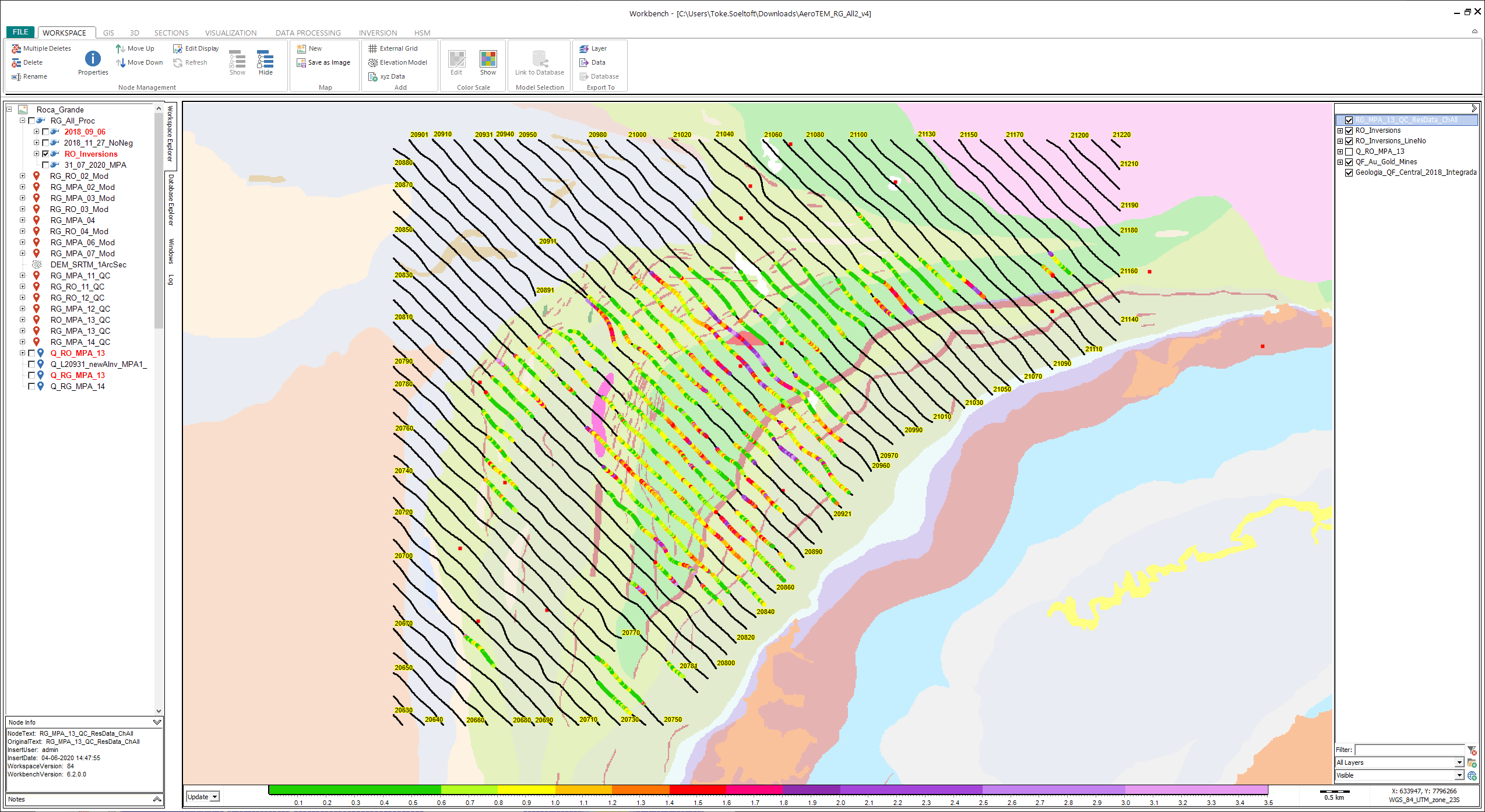
Survey area with flight lines (black lines). The colors display the data residual for all the models used in the inversion.
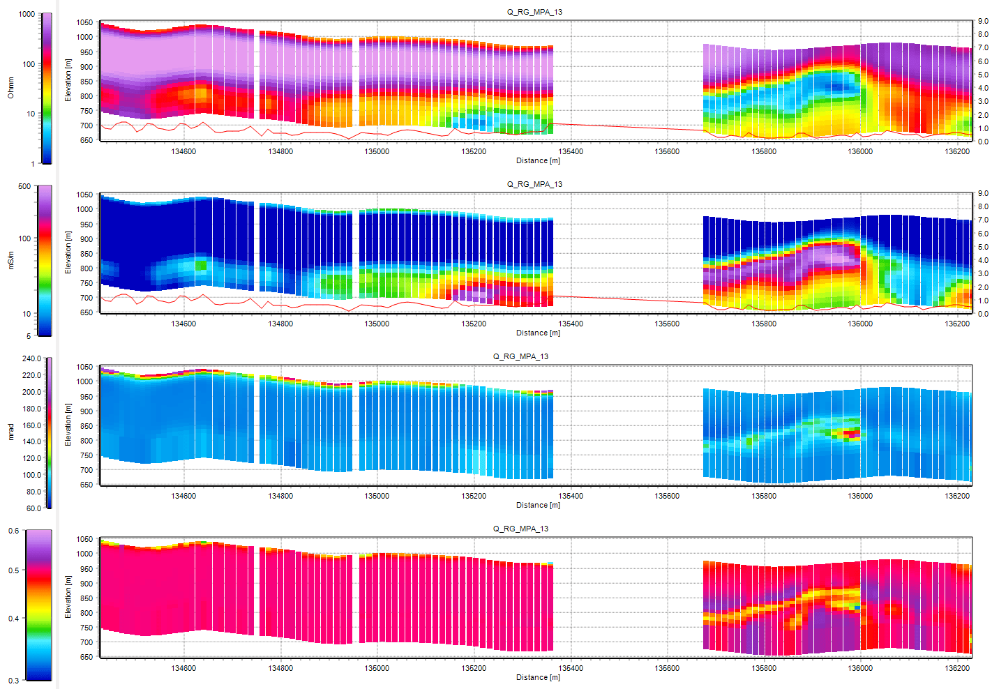
Model results for line 20990 with a polarized body at 13600 m. From the top, the plots display resistivity, conductivity, phi, and c. The red line displays the residual; how well the models fit the data.
How three gold mines sprang into a clearer view
The project tested potential airborne IP tools, algorithms, and hypotheses on data from the gold-bearing region of Quadrilátero Ferrífero, MG, Brazil. The team inverted data from an AeroTEMHD survey affected by IP using the airborne TEM-IP extension for AGS Workbench and then imported the inversion models into Oasis montaj to compare it to the gravity and magnetic models, increasing confidence when presenting results for three areas.
The study focused on recovering the IP parameters and correlating their magnitude to geology. In mineral exploration, the chargeability information helps identify mineralised zones, often associated with metallic sulphide dissemination.
Without plunging into the technical depths of the research – some of which is still to be released in full – the overall findings were that including IP data effectively tightened explorers’ grasp on and understanding of an area. It helped remove anomalies that resistivity alone couldn’t resolve, render artefacts more clearly, reduce data misfits and produce results that were a better and more confident match to the area’s geology.
“It can change your entire understanding of the structure and geology of a mine,” explained Marco. “So, for example, you might have a resistor that couldn’t be explained geologically. It might appear as an artefact based only on resistivity, but with the addition of IP, you have a better image of the graphite schist, which results in a much better understanding of the structure of the graphite layer.”
The study concluded that ‘the modelling of AEMIP had demonstrated the achievement of more reliable resistivity models compared to the ordinary resistivity only inversions. In the context of mineral exploration, the integration of AEMIP data with magnetic surveys could be useful to solve ambiguities in geophysical models.’
In short, says Marco: “more detail means less risk. And you’re already paying for it, so why not use it.”
What the future holds
Why Seequent?
Intuitive, collaborative, integrated; Seequent software brings clarity to the complexity of geo-data and decision making.
We enable geo-data to tell a story with software that combines in-depth analysis, 2D and 3D visualisation, and data management. Accessible on desktop and Cloud, Seequent brings together the trusted power of Leapfrog 3D, Geosoft, and GeoStudio software. Our solutions integrate with industry-leading tools and have an open API so that all data and workflows can be considered.


