


Seequent’s geophysical inversion software AGS Res2DInv has been the key to unlocking bigger, better water supplies for parched communities across the globe – even when those supplies play hard to get. And for Living Water International, this software reshaped their approach to locating it.
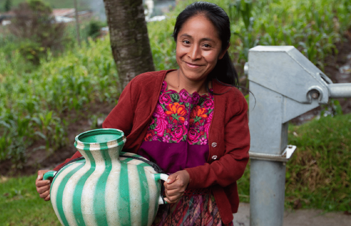
Living Water International is a US-based NPO that brings clean water to communities in need around the world. Since its launch in 1990, it has completed more than 18,000 water projects in Central America, Africa, and India.
At the heart of their mission is the ability to find and drill for water, and they have been successful for decades, helping hundreds of thousands of people flourish and safeguard their health and families. However, as Global Fleet Manager Chris Hough remarks, the challenge was escalating. Traditional methods, based on our understanding of local formations and past experience, were proving inefficient and costly.
“We found as we were using bigger and more expensive drill rigs to drill deeper, through harder formations,” explains Chris. “The number of attempts to find aquifers was steadily increasing, and so was the expense.
Work smarter, not harder
“We realised we needed to work smarter, not harder, and utilise science before we began to drill.” The solution, suggested by their long-term collaborator, oil industry researcher, and leader in the field of resistivity, Dr Robert Wiley, was to use resistivity surveys to enhance exploration, and they turned to Seequent’s geophysical inversion software Res2DInv to make sense of the new data they were harvesting.
The combination of their existing drilling equipment and the insights delivered by Res2DInv began to convince Chris and the Living Water team that they could do better.
“With the old way, we would always stub our toes. There would be a lot of challenges. Maybe we’d find water, but maybe we wouldn’t. Or maybe we wouldn’t find enough. So, we would move and drill repeatedly, and it was burning supplies, materials and money.
”Res2DInv improves all of that. It makes it much easier to be successful the first time.
Chris HoughGlobal Fleet Manager
“We’ll spend a couple of days in the field running surveys, gathering the information, and putting the data into Res2DInv. This means that most of the time, we already know there is a water-bearing formation before we even start to drill. Or we know not to waste money drilling because there’s saltwater intrusion and it’s obvious in the results. It just works.”
What is a Resistivity Survey?
Resistivity surveys measure the ground’s electrical resistance. Distinct materials possess unique resistive properties. Water-bearing formations (aquifers) typically display specific resistivity values, distinguishing them from surrounding layers.
Enter AGS Res2DInv. A game-changer for finding aquifers, Res2DInv processes resistivity survey data, converting it into a 2D subsurface resistivity profile. This visualisation facilitates the identification of potential underground water sources, optimizing drilling decisions.
How Does Res2DInv Work?
The approach Living Water International now follows is:
- Conduct a resistivity survey in the potential area.
- Input this data into Res2DInv.
- Review the 2D subsurface resistivity profile pinpointing potential water sources.
- Decide the most favourable drilling spot rooted in Res2DInv’s insights.
Gone are the days of repeated drilling based on mere guesswork. With Res2DInv, Chris notes, “Most times, we’re already aware of a water-bearing formation before drilling commences.”
Additionally, the software proves invaluable in detecting pitfalls like saltwater intrusions. Before adopting Res2DInv, the team often faced the challenges of such false positives. However, the software’s distinct algorithms differentiate fresh, and saltwater based on unique resistivity parameters.
Spreading technical acumen across the globe
A core value of Living Water International is to develop people. Empowering staff supports the development of long-term access to safe water in the WPAs (WaSH (Water, Sanitation, and Hygiene) Program Areas) in which they work.
So, after their initial success, they began to tutor team members on bringing the software to their local water projects. “We said to the field engineers, drillers, and programme managers, this is a tool you should really add to your toolbox.
“We have now trained 31 students in 9 LWI country offices, providing them with new skills to improve their ability to select locations and increase their chance to find water in their communities.”
As an example, at one spot, a Living Water project drilled in the traditional way and came up with a few litres of water. They drilled again and came up with a few more. “Then they decided to try to do what we’d just taught them, and they came up with something in the order of two cubic metres of water an hour…”
Res2DInv’s ability to point to these larger well yields is also important to the direction Living Water is taking – away from single-hand pumps and towards piped water systems, with storage, and opportunities for improved sanitation and hygiene that can future-proof a community’s health and clean water supply.
Acceptance, engagement, and a route to more funding
Their ‘embrace the science’ programme has also carved a path for increased funding opportunities. This used to come from churches or individuals, but now the group often partners with local government and other NGOs.
“Being able to show them the surveys and the results we’ve been getting has been very exciting and successful in encouraging engagement. For example, in Nicaragua we were able to create a hydrogeological report for the board of water stakeholders in the area; something they’d never had before. Not only was it valuable to them, but also solidified our credibility.
“So far, we’ve completed surveys in around 20 communities, and I feel like we’re just on the cusp. The guys and the gals in the field are adopting this and getting excited about it. Res2DInv is accurate, it presents well on their laptops, and you can see the lightbulbs start to come on for them as they realise how beneficial it can be to what they are doing.
“They’re going to use Res2DInv multiple times, in multiple countries and geological areas, and for multiple communities, to touch the lives of many, many people who don’t have access to clean water.
Two days day in the diary of Living Water International
DAY ONE: One of the projects where we were able to carry out field training was in La Reforma in Guatemala. This was a location where LWI had been asked to drill a well for a local clinic. There was already a well several blocks away, on the edge of a soccer field, with a screen set at 40 metres. We ran a vertical electrical sounding (VES) survey along the street beside the field and identified that the aquifer had a resistivity of about 40 ohms/m.
We also knew there was another well about 100 metres from the clinic, along a narrow dirt road, in fact, two wells with aquifers at 5 and 10 metres. However, the owner indicated that the water quality was not good.
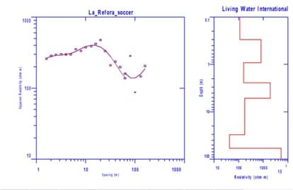
Vertical electrical sounding (VES) survey at the soccer field.
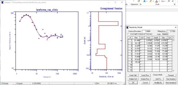
VES results from the clinic.
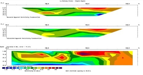
Dipole-dipole results alongside the clinic.
DAY TWO: We ran a horizontal survey along the side of the road in front of the clinic where there were only minor variations in the readings. One slightly lower reading was at the clinic itself. Based upon this we ran a VES centred at the low reading on the horizontal survey. The VES identified that there were two anomalies likely associated with aquifers: the shallowest at 10 metres depth and the second about 40 metres.
However, the shallow potential aquifer was consistent with the well along the dirt road where the owner had reported issues with the water quality. Meanwhile, the deeper anomaly was consistent with the community well at the soccer field. This would indicate that the aquifer at 40 metres deep likely covered a large area.
As part of the training we also performed a dipole-dipole survey along the dirt road to the side of the clinic. This also demonstrated a low resistivity at a depth of about 40 metres.
OUR RECOMMENDATION: That a well should be drilled on the clinic property at a depth of about 40m. This was a success both in terms of the water delivered to the community and for the 12 people who participated in the training programme. All of them gained an understanding of the correct field procedures and the best practices for safety and accurate data acquisition – and the clinic gained a new, good quality, clean water supply.