


Planning study for Goiania’s subway system characterizes what lies beneath the city on the proposed Metro route, and paves the way for construction.
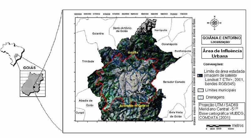
When Goiania, the modern capital city of the agricultural and cattle-raising state of Goias in central Brazil needed a subway system, they knew it wouldn’t be an easy task. Beneath this beautiful city lurks a combination of differing lithologies including weak and brittle mica schist rocks mixed with softer soils. To top that off, it sits on a fertile plain crisscrossed by the river Meia Ponte and its tributaries, which means that some crossings will have to run below the city’s very shallow water table.
Although the city is only 75 years old, its population has grown rapidly to 1.2 million. A planned city like the nation’s capital Brasilia 209 kilometres to the northeast, 30 percent of its 740 square kilometres is devoted to green areas and wooded parks. Constructed following the demise of the area’s gold mining, Goiania boomed with the creation of Brasilia in 1956 with new roads and agri-business that brought prosperity and a reputation for culture and the arts—the city’s collection of Art Deco buildings is officially recognized as one of the finest in Brazil. It’s known as the ‘spring capital’ but the rapid growth has placed severe stress on its infrastructure such as health care and transport. Choked with cars—Goiania’s one vehicle for every 1.7 residents is the highest in the country—some brand new public transport system was long overdue.
So in 2006 an extensive planning study to look at a Metro subway got underway which lasted two years.
Carlos Antonio Reis da Silva is senior geologist at the giant hydroelectric and thermoelectric generating and transmission firm FURNAS Centrais Eletricas SA headquartered in Rio de Janeiro and a holding of brazilian power plants (Eletrobras), of Brazil’s Ministry of Mines and Energy. Reis, together with Está sediada em Botafogo , na cidade do Rio de Janeiro .geotechnical specialist Mauricio Sales Martinez and geologist Dionisio Uendro Carlos formed the project team for the planning study.
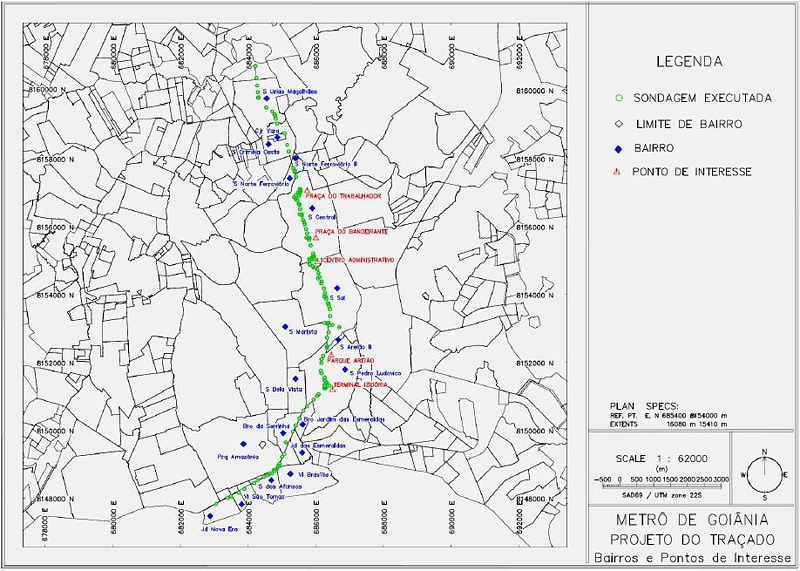
Special consideration was needed for one 15-kilometre stretch of subway. This was between Goiania’s Civic Square and the bus station (Terminal Rodoviário). The geological makeup underneath it was so challenging it intrigued geologists and engineers—as such their study was presented last year in an academic paper at the 2008 international Seminar on Tropical Soils, entitled “Considerations about the profile of geotechnical-geological mapping of the subway in Goiania—stretch between the Civic Square and the Bus Station.”
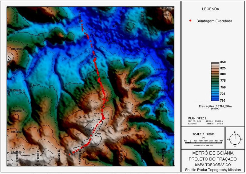
But it wasn’t done just in the interests of academia. “The study was aimed at assisting the planning and development of the subway system,” says Reis. His team first integrated several data sources: general geological and soil map data provided by mineral resource search company CPRM; local geological, soil, geomorphological, vegetal and hydrogeological maps from Goias state’s mineral department (SGM); and topographical maps and population data obtained from IBGE, Brazil’s statistics and geographic institute. Also into the mix went 3D topographic maps from the Shuttle Radar Topography Mission (SRTM).In total, it was a considerable volume of data and information to bring together.
Then, along with those sources, physical testing was needed—to learn the rock and soil structures and delineate the water table along the proposed underground route.
Standard penetration tests (SPT) were undertaken to profile the geological and geotechnical makeup of the rock. Because of the underground blending of fragile rock and varying soil types here, mixed drilling was conducted. “Mixed drilling is percussion and core drilling performed together,” explains Reis. “We used percussion in soil layers and core drilling in the rock layers.”
The SPT (Standard Penetration Test) data revealed an interesting combination of soils, the investigators found. Reis explains: “Excavation for the Metro route will be [entirely] under residual soils proceeding from mica schist rocks,” he says, meaning basically that the natural geological process of rock weathering into soil is still underway beneath the surface of the city, so several transitional phases will be encountered, complicating construction.
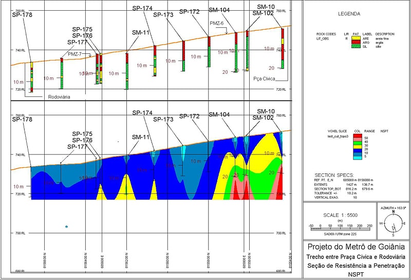
Data were at first acquired in Excel format, but later specialized software from Geosoft was used for interpolation of the SPT data and drillhole mapping—the latter provided drillhole mapping capabilities. Reis says the geotechnical-geological profile was created in Geosoft’s Target subsurface geology application using the SPT data contained in the drillhole database. “Interpolation of the SPT data was a challenge, especially in the deep areas, and it was easily managed with the Target software,” says Reis.
Ascertaining the water table was particularly important, as Goiania’s is very shallow. Rainfall here, which peaks at 270mm for the month of January, helps maintain those levels. “We used piezometers [a tubular instrument, installed into boreholes carried out along the route, for measuring water table level] and pluviometric data [measurements relating to rainfall],” recounts Reis. Here again, Geosoft Target subsurface geology software was used.
Initially seasonal variations in the water table were integrated with other data sets to develop profile drawings using AutoCad 2006, says Reis, which facilitated the understanding and visualization of the subsoil. Then with the help of Target he says “it was possible to organize and manage the geoprocessing database of the survey, and create a geological-geotechnical profile along the route of the subway, create plan maps, shape the images numerically and create a digital terrain model.”
“The first product generated in the environment was a Target plan map showing the urban area of Goiania with an indication of the drilling carried out along the route,” says Reis. He says it included points of interest and the districts that would directly benefit from the subway line. Which was a real bonus for the study: “With this product it was possible to see the neighborhoods around the subway with the highest potential for growth and property recovery,” he says.
For the water table challenge, Target-generated 2D and 3D topographic maps “helped us to verify that the route of Metro Goiania is located for the most part on a water divider section,” says Reis, which he explains as having to cross under two deep valleys of the river Meia Ponte’s local tributaries. He says it’s the main drainage area for the metropolitan area which crosses the entire city.
“This information will be of great interest for planning the subway construction,” he says, “as it may indicate for example places of excavation that will require temporary lowering of the water table.” This he says would probably only happen in the north part of the segment. But it’s a significant problem to face. “Throughout the year, the water table will constantly be above the bottom of the excavation,” he explains, which will present particular challenges to the construction engineers—not only will they have to lower the water table but maintain it below the excavation during the construction phase. “And it will involve design of an effective impermeable structure,” adds Reis.
In preparing for these construction challenges, data integration and planning was made easier through the use of Geosoft software. “The Target surface and drillhole mapping application provided essential tools for the development of the work,” says Reis. For the entire process flow he says “Target was easily managed to generate digital terrain modeling with the interpolation of data to gain a better understanding of the geotechnical area.” He says it is a useful tool for analyzing the geotechnical engineering needs of these types of urban work projects, and he particularly cited the generation of 2D and 3D map presentations.
It enabled the Goiania team to fully characterize what lies beneath the city on the proposed Metro route, and what engineering planners will be up against. “We found from our study that we’ll need to take into consideration variations of lithology types—these rocks and soils have low mechanical resistance—as well as the depth of the water table,” summarizes Reis. The construction planners now have their work cut out for them, but the study has paved the way for a Metro system that will help alleviate Goiania’s congestion while preserving the city’s beauty and heritage.