


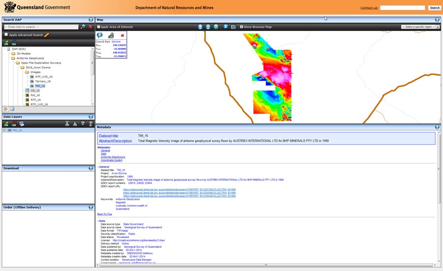
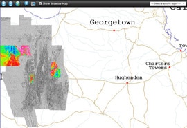
The Geological Survey of Queensland (GSQ) has unveiled QDEX Data, a project that has been two years in the making. The new online system, based on Geosoft DAP Server technology, allows individuals and companies to access Queensland’s survey data seamlessly, quickly, and free of charge, says the Survey’s Geoscience Manager Mark Thornton.
Under the old distribution method, none of the GSQ’s datasets were available for download. They had to be manually packaged to media and then posted out to people, a service for which the GSQ charged a fee.
The old process was slow and laborious explains Thornton: “The data had to be found, cleaned up or prepped, and shipped off,” he says. “Then payment had to be arranged, and so on.”

QDEX Data replaces the manual approach with an à la carte solution: Users are able to log onto the site, locate the datasets they require, and download them at no cost.
More datasets are constantly being added to the system. Meanwhile, explorers will see immediate advantage in the website’s data catalogue. Whereas previously they had to contact the GSQ to find out whether certain data were available, now they can look through an online catalogue and place their orders using the shopping cart.
The cataloguing initiative speeds up the rate at which the GSQ is able to process requests and also helps with future requests. “Up to now, we’ve had all this uncatalogued data,” says Thornton. “To find it, you had to wade through folders and directory structures.” With the new procedure, the client receives the data it requests and that same data is then entered into the online database, making it available for future reference.
There’s a tremendous amount of data. Decades of surveys – many of them conducted before modern standards existed – will take time to prepare and package for download.
“The bulk of our data is seismic, and I think there are only two seismic surveys in QDEX Data right now. It’ll take a while before we get them all done,” Thornton says.
“We’ve been going through the data for some time now,” notes Thornton. “There are 1,100 seismic surveys that don’t have a spatial location in our online geographic information system. That means a lot of data has to be opened up and the relevant information extracted.”
What’s more, many of the older surveys were only partly digitized. In parallel with the QDEX Data roll-out, the GSQ has hired subcontractors to scan older survey data, in particular ancillary data that exists only on paper.
In the case of surveys that don’t have SEG-Y data, the GSQ is scanning the old seismic profiles to a resolution that allows them to be translated into SEG-Y data. “So we’re adding value as we package the seismic data,” explains Thornton.
In addition to the geophysical datasets, the system will contain a wide range of other data, including seismic surveys, wireline logs, geochemistry data, even gravity gradiometry surveys. This variety of data and file types is one of the reasons the GSQ opted for Data Access Protocol (DAP) Server technology.
“We needed the ability to search for and download any type of file,” says Thornton. “There are a lot of packages that are only for geophysics or only for something else, but DAP allows us to package and deliver virtually anything, even a large PDF publication if necessary.”
The versatility is intentional. Henry Wang, Geosoft’s Senior Solutions Architect, notes that Geosoft DAP Server was designed and developed with government organizations, such as GSQ, in mind. “The capabilities of DAP Server, for searching, viewing and extracting geoscience data over the internet, are well suited to government agencies with a mandate to provide geoscience data to the public.”
As part of the implementation, file size is a key challenge that needed to be addressed. To make download times manageable, the packages are being split up into chunks of around 1 GB each, for a download time of roughly one hour via an ADSL (Asymmetrical Digital Subscriber Line) connection, or about six minutes by cable modem.
“The geochemistry database, for example, is now split into five sub-sets that correspond to five regions in Queensland,” Thornton notes, “and they’re all about 1 GB each, as opposed to 5 GB for the whole state.”
Where the package is too large for online delivery, customers can still order pre-packaged data for offline delivery. Online data downloads will be free while offline packages will incur a fee for postage, packaging and handling.
So what will the new system look like? Thornton explains that the QDEX Data system is being released with a Flamingo web interface. That said, users of Oasis montaj or MapInfo will be able to access datasets directly from their software packages using the Seeker plug-in.
Looking to the future, Thornton says there are other portal technologies being developed in Australia, and these will also be able to interface with the server.
“The benefit is that we have fairly open technology behind the system, while also having off-the-shelf products from Geosoft that are already in use worldwide. Geophysicists and geologists who are familiar with DAP or Seeker can easily access the Queensland survey data while working within their applications.”
“This provides a ready introduction to an audience who would otherwise have been manually requesting data from us in the past,” he adds.
There is also a larger, country-wide context to consider. The federal agency Geoscience Australia has the Geophysical Archive Data Delivery System (GADDS), which contains copies of the state-level surveys, but GADDS is becoming dated and may soon be phased out completely.
As more public data moves to portals, like the Queensland one, the industry could potentially have online access to geophysics anywhere in Australia. The ability to view data for the entire country online (rather than hunting for data in separate databases) will be a major benefit to explorers, especially those who work along the border between multiple states.
While country-wide, seamless integration is still a ways off, the QDEX Data service is now live and explorers and mining professionals can judge the advantages for themselves.