


New data generated from the largest airborne geophysical survey ever undertaken in Nigeria is helping to position the country as an exciting destination for explorers.
Accessing detailed geological and geophysical information for any part of Nigeria is about to become a whole lot easier. With the country’s new National Geophysical Data Management System, an interested explorer will be able to simply go online, zoom in on an area of interest, place an order, make the payment and download the data. “The availability of these geophysical data sets will help investors both local and international to take less risky and quick decisions on investment in the country,” says Olaniyan Oladele a geologist with the Nigerian Geological Survey Agency (NGSA). “This will in turn boost mining activity in the country and in Africa in general.”
Courtesy of the NGSA and PGW
What has made it possible began with a massive country-wide airborne geophysical survey started in 2003 which has amassed several thousand flying hours. Several thousand more person-hours have gone into the processing and presentation of the data. As it nears completion, there are still more hours to come—ground truthing, and some more intense aerial coverage of oil and gas prone areas.
The new undertaking is sorely needed. Aeromagnetic surveys in Nigeria flown in the 1970s have played a key role in understanding the country’s regional geology, but due to their low resolution had become of limited use. Although they covered most areas of the country, the survey data was acquired at 2 km flight line spacing and exists in analogue paper format in the archives. Government initiatives to diversify the country’s national income away from dependence on crude oil resulted in the new project—proposed to carry out airborne and radiometric surveys for all parts of the country and further electromagnetic and gravity surveys in specific mineralized areas, says Oladele.
Courtesy of the NGSA and PGW
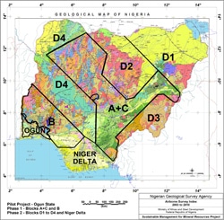
The survey was initiated by Professor Siyan Malomo, Director General of the NGSA, and it was conducted in two phases. Phase 1 was financed entirely by the Government of Nigeria. All of the airborne geophysical work – data acquisition, processing and interpretation, was carried out by Fugro Airborne Surveys. Phase 1 was completed in September 2007 and included 826,000 line-km of magnetic and radiometric surveys flown at 500 m line spacing and 80 m terrain clearance; and 24,000 line-km of time-domain electromagnetics surveys flown at 500 m line spacing and 80 m terrain clearance using Fugro’s GENESIS EM system. Fugro was also tasked with interpretation of these data.
Phase 2, completed August 2009, surveyed blocks not covered in Phase 1. It included 1,104,000 line-km of magnetic and radiometric surveys flown at 500 m line spacing and 80 m terrain clearance. These levels of survey are intensive: often a total of seven aircraft of three different types were active at one time.
Phase 2 was supported by the World Bank as part of a major project known as the Sustainable Management for Mineral Resources Project. Fugro Airborne Surveys carried out the data acquisition and data compilation. Another firm, Paterson, Grant & Watson Limited (PGW) is carrying out the data processing and interpretation. PGW is also preparing the nationwide grids and synoptic interpretation, incorporating all Phase 1 products and the results of an earlier pilot project from Ogun State in the southwest part of the country. A consortium of independent consultants, Geoexploration Nigeria, GeoWitch and Earthworks, were contracted by the World Bank to provide advice, logistics, training and quality control (QC).
Additional airborne EM was added in specific areas of interest. Past history, known geological information and geophysical signatures of metallic minerals such as lead-zinc and other sulphides were used to determine areas for further airborne EM surveying.
And there’s still more flying scheduled for 2010, when it is expected to wrap up. The entire Niger Delta block will be flown with aeromagnetics at 1 km line spacing, with a further one quarter of the Delta with airborne gravity.
As large as the acquisition task was, overall it was just one part of the workload. The task then came to pull together all the dozens of gigabytes of data, interpret and present them. It wasn’t just the new data, either. The older analogue data still contained useful indications so had to be integrated with the newly acquired. “Most of the old data have also been digitized and stored in a Geosoft database format,” says Oladele. “It’s been very interesting comparing the old data with the new dataset. Both show similar anomalies but at different resolutions.”
Interpretation has had its share of challenges. “The Nigerian Geological Survey Agency is currently transitioning from the analog to the digital world, particularly with its geological maps,” says Stephen Reford, vice president at PGW. “Getting our hands on some of the geological material took time, and certain new digital products were not properly geo-referenced.” But he says these issues have been rectified. Reford says that despite the country’s reputation for security and corruption, he found that didn’t match reality. “Our dealings with government agencies have been completely transparent and professional,” he says. “We have lived in and moved around the central part of the country without any sense of danger.” It bodes well: they have a month-long ground truthing program in many parts of Nigeria coming up this year, “which will be an interesting challenge to coordinate,” he says.
With such a massive and important project, it was imperative that a high degree of quality control was maintained throughout all phases. It was in fact a requirement by the World Bank; largely to ensure that data from different lots would be error-free, compatible and comparable, and could be compiled into a consistent countrywide dataset.
“Comprising some two million line-km of three-sensor magnetic data and 256 channel gamma-ray spectrometry, this was not a job to be taken on by the faint-hearted, impatient or ill-equipped,” says Sally Barritt of GeoWitch. “Full coverage (almost) of the country was achieved using several aircraft over a series of blocks and sub-blocks, the flying of which needed to be coordinated to accommodate the quirks of the Harmattan and rainy seasons, while minimizing the effects of environmental variations on the quality of the data.”
Barritt says they accomplished the data acquisition part of the QC largely through a series of 10-14 day, on-site visits at approximately three to four month intervals. Each trip involved the routine QC of some 200,000 to 300,000 line km of data and a reassessment of the cumulative coverage. . “Any specific test/calibration data and or requests to check certain flights of data or other issues could be dealt with remotely during the intervening periods,” she says. “I would say that the biggest challenge was trying to ensure consistency between different aircraft systems and also, for gamma-ray spectrometry, consistency between data collected during different seasons.”
Similarly, QC of the final processing required several visits to the contractors’ offices and remote follow up; and consisted of preliminary/exploratory processing. “Not all potential problems, nor the geological value of the data, are immediately obvious in the raw field data,” she explains. In the end, she had to be sure of seamless, country-wide datasets. “With so many individual blocks and sub-blocks of pretty irregular shapes making up the countrywide coverage it was essential to ensure that these would all link together without the necessity for large shifts or warps.”
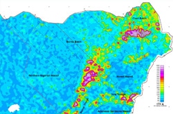
PGW’s massive task of processing is in the interpretation stage and still a work in progress, but Reford is pleased to be able to talk about some important conclusions that can already be drawn. He notes that depth-to-magnetic source mapping has proven very useful in assessing the inland basins, both to delineate the thicker accumulation of sediments where the oil & gas potential is higher, and to locate some quite large regions where the sedimentary cover is thin and the shallow basement has the potential to host minerals at economic depths. When it comes to gold deposits, these are hosted by schist belts in western Nigeria. “The magnetic and radiometric data have proven instrumental in extending the known schist belts,” says Reford, “characterizing their lithology and locating structures that are controls on the mineralization.”
There are more, he notes. Nigeria is known for its older and younger granites. “The airborne data show that the character of these granites varies considerably, and will allow assessment of which mineral deposit types may be associated with certain classes of granites,” says Reford. And, for diamond potential, the Kafur kimberlite pipe was already described in the literature as having been discovered in 1961 but the new data are revealing. “The aeromagnetic data display a discrete signature for this pipe and associated structures,” he says. “Similar magnetic anomalies in the area are targets for exploration.” Reford expects new findings in the oil-rich Niger Delta, too, once it is flown this year.
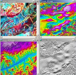
A wide range of software has been used to assist in all phases of QC, interpretation and presentation. Geosoft’s Oasis montaj mapping and processing software, and GXs (Geosoft Executables) developed by PGW were utilized for imaging, map preparation and interpretation; montaj Magmap was used for a range of processed magnetic images; variable reduction-to-the-equator to account for the wide range of magnetic inclinations and declinations across Nigeria; source edge detection to delineate magnetic contacts and anomaly peaks and source-parameter imaging for depth-to-magnetic source imaging.
“All final products are being delivered in ArcGIS, so the interaction between that software and Geosoft is quite important,” says Reford. “It has allowed us to combine the strengths of both products, for example using the ArcGIS ‘grid with barriers’ technique to combine interpreted structure with the depth-to-magnetic sources prepared with Geosoft.”
Reford says the interpretation is being prepared at the 1:250,000 scale on Nigeria’s standard map layout, with a nationwide synoptic interpretation at the 1:1 million scale. Each map sheet incorporates three interpretation products: litho-structural (basement, intra-sedimentary and sedimentary); geophysical (geophysical elements and character); and regolith (surficial material and geomorphology). Accompanying each map sheet will be a report, cross-section and series of images incorporating magnetic, radiometric, terrain and Landsat data. He adds that the interpretation and geophysical imagery will be delivered in a GIS format for digital archiving and interrogation.
Filling the requests for the new data sheets will be the role of the NGSA’s Customer Service. “The NGSA is mandated to archive all geological and geophysical datasets for the entire country,” says Oladele. “We provide the data to investors and researchers as demanded in both raw (.gdb or .grd) and image maps (PDF or JPEG) format.” He adds that the service will be more than simply providing data; they will help interested investors to further customize interpretation and further ground survey where necessary. As well, assistance such as providing extraction of smaller, regional or local grids from the much larger master grids is to be offered.
The NGSA has been working with Fugro Airborne Surveys who have sub-contracted Geosoft to deliver the National Geophysical Data Management System utilizing Geosoft DAP server technology. It’s all ultimately part of the World Bank supported Sustainable Management of Natural Resources Project in Nigeria.
“The new high-resolution airborne survey coverage in Nigeria provides a wealth of information that will illuminate geological thinking for decades to come,” writes PGW’s Reford in a summary for an upcoming international conference. “It forms a key component of the country’s strategy to encourage investment in the minerals sector and broaden oil & gas exploration beyond the Niger Delta.” He describes it as a “national treasure”.