Inversion type
Time-lapse inversion
Survey configurations
Inversion methods
Live pseudosection updates
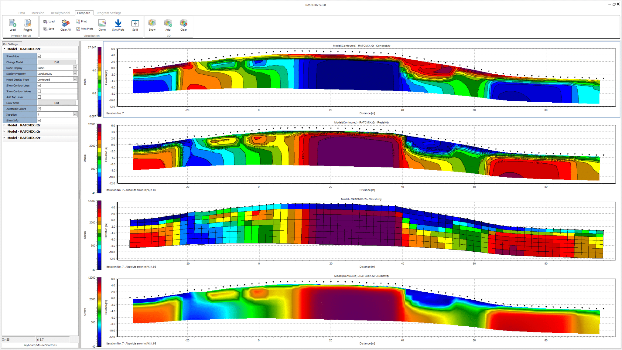
Model comparison tools
3D visualisation
Mesh size
RAM support
Vector array datasets
Export formats
Use case fit


Go to Bentley's eStore
Seequent products can be purchased securely through Bentley's eStore. Seequent is the Bentley subsurface company.
Prices shown on Bentley's eStore will be displayed in your local currency excluding tax.

Res2DInv and Res3DInv help geoscientists quickly turn resistivity and induced polarisation (IP) survey data into reliable 2D and 3D subsurface models.
Built for near-surface investigations, the software supports a wide range of survey configurations—including boreholes, water bodies, and time-lapse monitoring—and delivers fast, reliable inversions using smooth, sharp, or constrained methods.
With a streamlined workflow and integration across the Seequent ecosystem, Res2DInv and Res3DInv make it easier to interpret complex geophysical data and share results with confidence.


Key benefits
Run smooth, sharp, or constrained inversions using advanced algorithms designed for speed and reliability—even on large datasets.

Support for topography, boreholes, water bodies, and streamed electrodes helps you model complex environments with confidence.

Explore 2D sections and 3D volumes, compare multiple inversions side by side, and export to Workbench, Oasis montaj, or 3D visualisation tools.
Use time-lapse inversions to track subsurface changes in groundwater, permafrost, or geotechnical conditions.

Import data from a wide range of instruments and formats and export results to Seequent and third-party tools for interpretation and reporting.
Apply smooth, sharp, or constrained inversion types to reflect expected subsurface structures and improve model interpretability.

Product Information
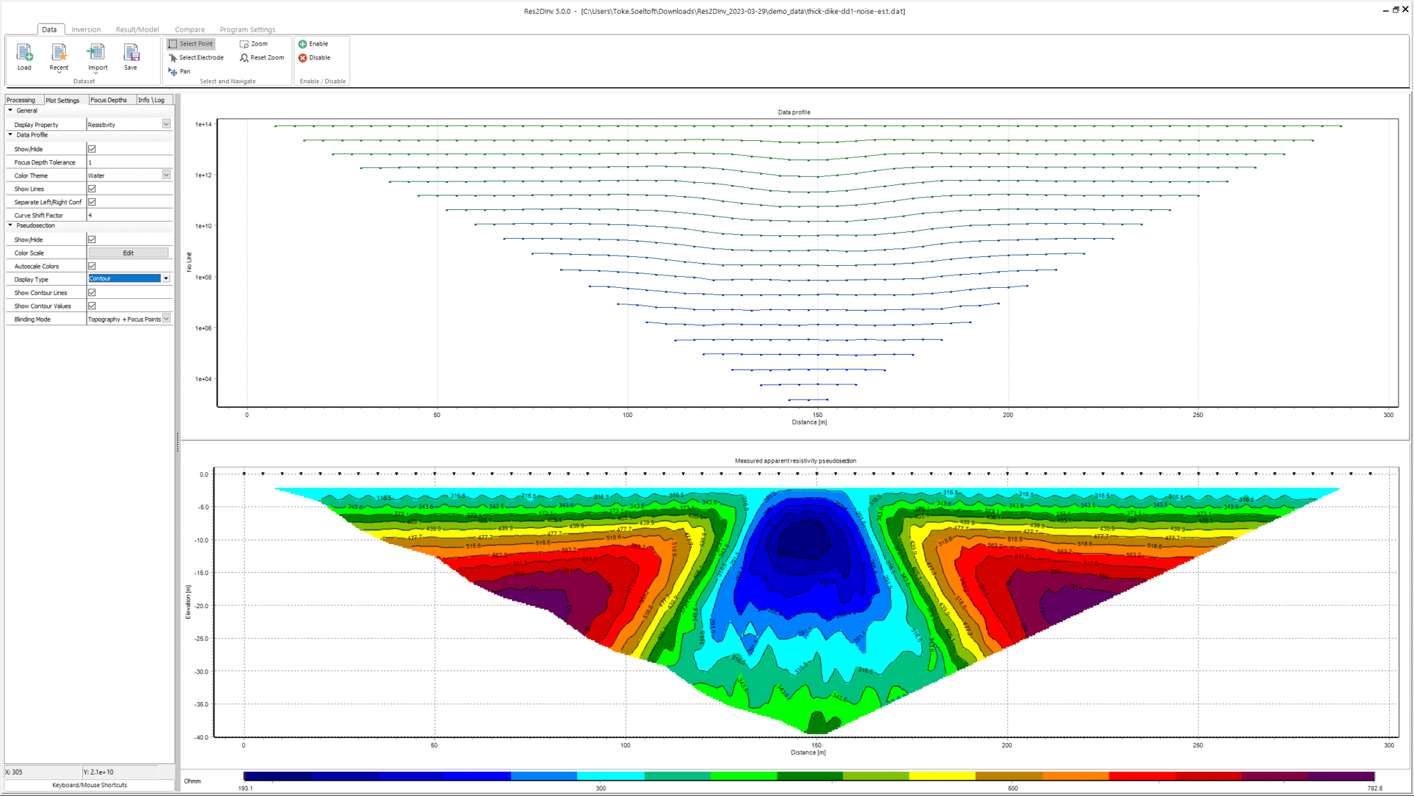
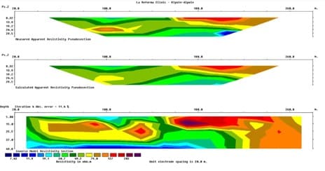
Res2DInv is designed for processing and interperting 2D electrical resistivity tomography (ERT) and induced polarisation (IP) data. It supports a wide range of survey configurations, including topography and boreholes, and provides tools for filtering, inversion, and visualisation. With live pseudosection updates and 2D time-lapse capabilities, Res2DInv is well suited for groundwater, environmental, and geotechnical investigations.
Request a demo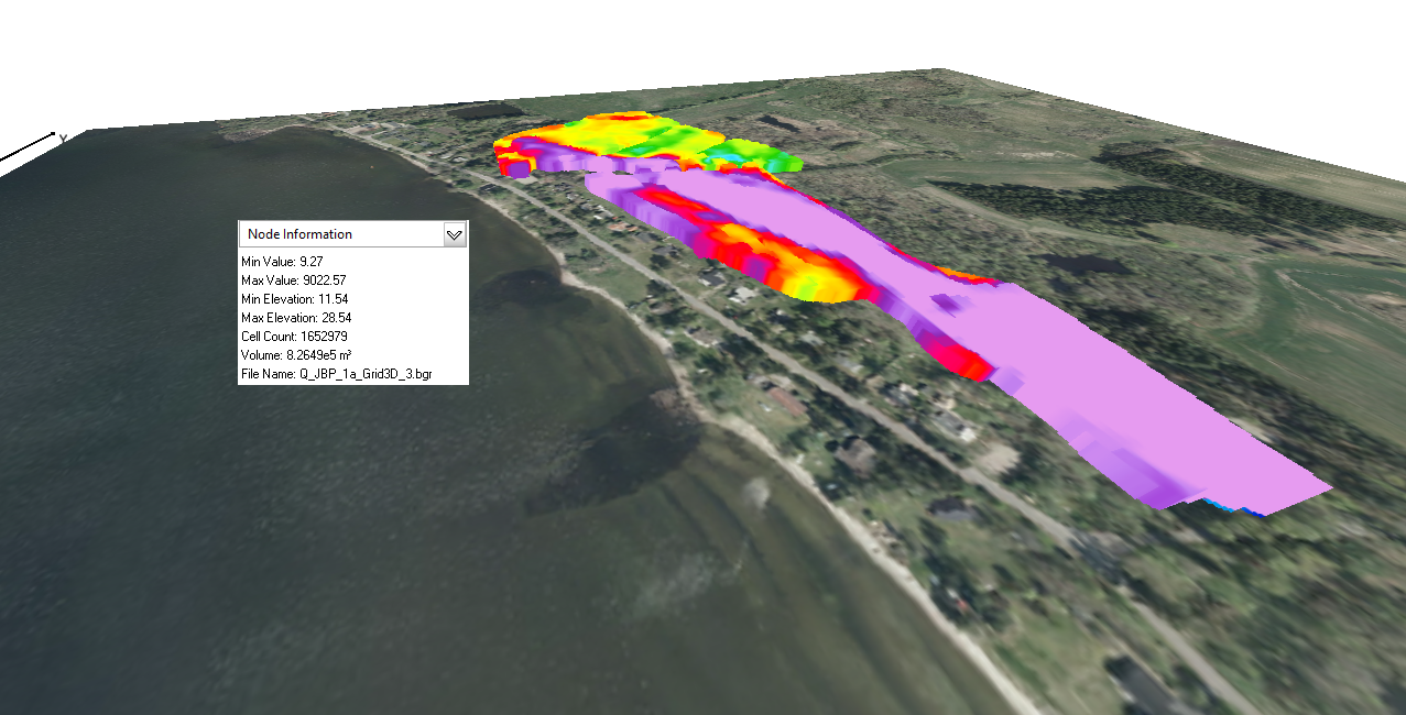
This bundle includes all the features of Res2DInv, plus full 3D inversion and visualisation capabilities. It supports true 3D datasets and combined 2D survey lines, with options for time-lapse inversion, vector array datasets, and large mesh handling. Designed for complex subsurface investigations, it is ideal for mining, infrastructure, and environmental monitoring projects that require detailed 3D modelling.
Request a demoFeature comparison
Inversion type
Time-lapse inversion
Survey configurations
Inversion methods
Live pseudosection updates
Model comparison tools
3D visualisation
Mesh size
RAM support
Vector array datasets
Export formats
Use case fit
pricing

Only 12 month named licences are available to purchase online. For shared and enterprise licences, please contact us.
Named license - allows unlimited use of the software for a single dedicated user during the subscription period.
Shared license - allows any number of users to access the software over the subscription period, limited to one user per seat at any given time.
Go to Bentley's eStore
Seequent products can be purchased securely through Bentley's eStore. Seequent is the Bentley subsurface company.
Prices shown on Bentley's eStore will be displayed in your local currency excluding tax.


Chris Hough, Global Fleet Manager - Living Water International
insights & impact
Explore case studies and articles showcasing Res2DInv and Res3DInv's diverse real-world applications
Resources
Accelerate your Res2DInv and Res3DInv usage with support from our team of geophysics experts
Onboard quickly and enhance your skills with our free, comprehensive online learning courses.
Grow your geoscience knowledge, connect with peers, and share insights from using Res2DInv and Res3DInv with others in your field.
Available on demand, anytime, anywhere. Find answers to your technical questions or speak with an expert.