


Fugro’s latest innovation in geophysical technology, WAGEO, together with Seequent’s AGS Res2DInv software can unlock crucial geo-data insights for more sustainable energy infrastructure.
What does the Loch Ness Monster and Fugro’s water geophysics (WAGEO) streamer cable survey technology have in common? One inhabits the murky waters of Scottish folklore. The other, developed in Germany, also thrives in the deep.
“And they are both nicknamed ‘Nessie,” says Alexander Eifert, Senior Geophysicist at Fugro. “The technology uses electrical resistivity measurements taken underwater, to create images of the subsurface and to analyse sediment and soil layers to better determine, for example, the optimal location and burial depths for infrastructure.”
“Unlocking geo-data insights are essential to help design, build, and maintain assets more responsibly and sustainably,” says Alexander.
Data collected from Fugro’s geotechnical surveys feed into 3D ground models to understand the subsurface underwater. Since the technology’s inception, Seequent’s AGS Res2DInv software has helped process and invert this data with speed.
Sustainable infrastructure projects, such as wind and solar, can support the global transition to more renewable energy and decrease our dependence on fossil fuels. But as the speed of climate change accelerates, so do the challenges for renewable energy infrastructure.
“This is where our WAGEO technology can help,” says Alexander.
Fugro’s innovative WAGEO technology uses a geoelectrical survey technique to measure electrical resistance of the subsurface underwater. (Image credit: Fugro)
A deeper understanding with geo-data
Fugro has clients around the globe, predominantly in the energy, infrastructure and water industries. Their team of 10,000 span 57 countries across the Americas, Middle East, Europe, Africa, India, and Asia Pacific.
“Our site characterisation solutions support safe, cost-effective design and construction of infrastructure, both on land and at sea,” says Ronald Tjemmes, Senior Project Manager at Fugro.
Population growth, urbanisation, and ageing assets are drivers of the infrastructure markets in the countries Fugro operates. While the ambitious global energy target to see 70% of electricity come from renewables by 2030 is pushing solar, onshore, and offshore wind power technology to mature rapidly.
“Our data expertise and technologies are helping clients to deliver more sustainable infrastructure across these industries and better adapt to climate change,” says Ronald.
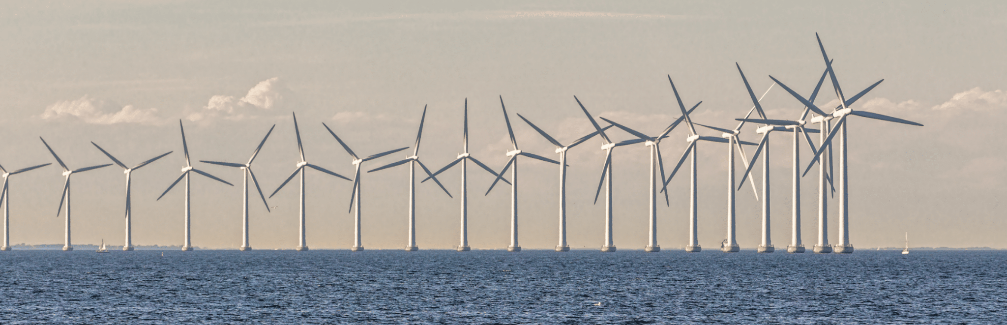
Fugro recently undertook a site characterisation campaign for a new wind farm in the Netherlands called Windplanblauw (Wind Plan Blue). The ca. 340 MW wind farm is being developed by SwifterwinT in collaboration with Vattenfall.
“We were excited to use our WAGEO technology as part of the investigations for nearshore wind farms and in support of accelerating greener energy options,” says Ronald.
The technology analyses sediment and soil layers at the sea or lake floor to help design and build more sustainable infrastructure (Image Credit: Fugro)
How does WAGEO work?
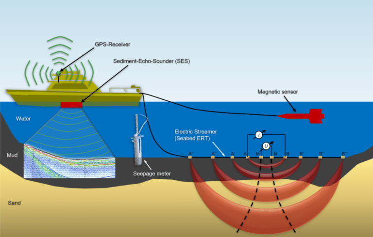
The term WAGEO refers to a set of several geophysical methods including hydroacoustic, geoelectric, in situ tests and direct sampling methods. Its most prominent feature is the underwater geoelectrical survey technology that measures the electrical resistance of subsurface sediments to determine variations in particle size and conductivity of the pore fluid.
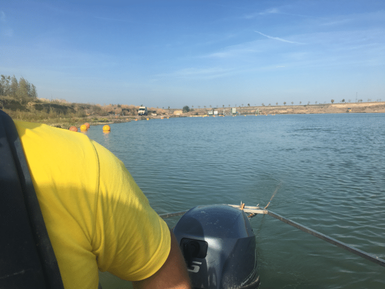
“To survey what’s below, we attach our 24-electrode streamer cable, our so-called ‘Nessie’, to a boat and tow it along the bottom of the water,” says Falko Oestmann, Senior Engineering Geophysicist at Fugro.
The geoelectric method injects electric currents into the earth with associated voltage measurements taken continuously, using a certain sequence of available electrode positions. Readings are referenced using the GPS position of the boat and the length of the array.
Seequent’s Res2Dinv inverts the large amount of measured data, and the calculated resistivity structure is used to create a geological interpretation.
Since the gridding of the data must respect the smallest electrode distances, the dataset is sparse but at the same time, extremely large – making it a unique processing task for the inversion software.
“Based on the patterns recorded, we can map out the different sediment types and distinguish between clay, peat, silt, sand, or gravel layers,” says Falko.
“The beauty of our technology is its flexibility,” he says. “You can take measurements anywhere – as long as there is enough water to track the streamer behind you. We can create profiles of any length and up to a water depth of 50 metres – or at the other extreme in very shallow water.”
Fugro’s WAGEO technology was recently used to analyse lakebeds for Dutch developer GroenLeven’s solar farms. The project involved the installation of anchor rods for over 100,000 floating solar panels on two sand extraction lakes in the Netherlands.
“We measured the lakebed’s soil layers to help find the best location and depths to efficiently place the anchor rods as part of a safe design for the renewables foundations,” says Serkan Elgun, Senior Geophysical Consultant at Fugro. “And because our survey technology has a light footprint we were able to carry out our non-intrusive analysis without any damage to the surrounding environment’s flora and fauna.”
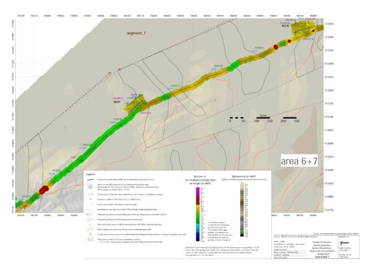
Wind turbine investigation geoelectric results showing the soft sediment/sludge layer in height (m NAP) as part of the Windplanblauw project (Image credit: Fugro)
Powering-up wind farm technology
Wind farms can play a fundamental role as the world looks to transition to more sustainable and decarbonised energy generation.
“Ensuring energy demand is shifted towards green electricity and ramping up renewable energy options is crucial,” says the team at Fugro.
The Windplanblauw wind farm project is located in the northwest corner of Flevoland, in the Netherlands, spanning both land and sea. 74 wind turbines in the project area will be replaced by 61 larger turbines to produce around 340 MW of energy. On completion, the wind farm will generate enough electricity to power 450,000 households.
“We recognise that much of the risk associated with major infrastructure projects lies below ground,” says the team. “Our site investigations with ‘Nessie’ allowed us to deliver the geo-data required to help SwifterwinT and Vattenfall optimise engineering and safety design for the wind turbine foundations. And assisted in selecting the most efficient cable route from the onshore substation to the turbines.”
Given the increasing scale, growing capital, costs, and risks of wind farm development, progressing from concept to reliable production as quickly as possible – is critical.
“On major projects such as Windplanblauw, our WAGEO technology collects huge amounts of data, resulting in very large inversion models,” says the team.
Seequent’s AGS Res2DInv has unique capabilities to carry out the inversion of these datasets and efficiently handle large models.
“The resulting 3D pictures enable us to easily see the characteristics of ground sediment and make better decisions to help move sustainability projects forward – faster.”