Seequent and Bentley applications establish 3D geoBIM analysis to help progress mass-haul strategy
Reducing emissions on a mega project
High Speed 2 (HS2), a new high-speed rail line from London to Birmingham is the largest infrastructure project currently being developed in Europe.
Even individual portions of the project could be considered mega projects in their own right. For example, the 90-kilometre route from Long Itchington to Handsacre (Phase 1 Area North), delivered by the Balfour Beatty Vinci Integrated Project Team (IPT), includes the development of over 100 mainline assets.
Rail projects typically involve a significant movement of earthworks. On this project, the team determined that over 21 million cubic metres of material – equivalent to 8,400 Olympic-sized swimming pools – would need to be excavated as part of the Area North works.

Peter Fair, 3D Geotechnical Engineer, Mott MacDonald
Jonny Neville, Senior Digital Consultant, Mott MacDonald
The process of excavating, transporting, treating, and placing the material are a significant source of carbon dioxide emissions.
Additionally, COP26, the 2021 environmental conference hosted by the United Nations, put a renewed focus on how engineers can contribute to climate change mitigation, and HS2 has committed to reducing carbon emissions by at least 50% during construction and operation.
The project team realised that with better understanding and visualisation there was an opportunity to optimise the mass-haul strategy and greatly reduce the emissions produced by the construction process.
Shortcomings of traditional geotechnical analysis methods
“An accurate understanding of the material types for the reuse of materials in earthworks is a prerequisite for the efficient delivery of construction and optimal use of materials,” said Jonny Neville, senior engineering geologist and information manager with Mott MacDonald.
By finding ways to reuse the excavated material, such as within the foundation of other assets, rather than hauling it away for disposal, the contractors can greatly reduce the material transported on public roads.
Additionally, reusing material excavated from the site would eliminate the need to import material from outside of the project site, further reducing the need to haul away newly excavated raw materials.
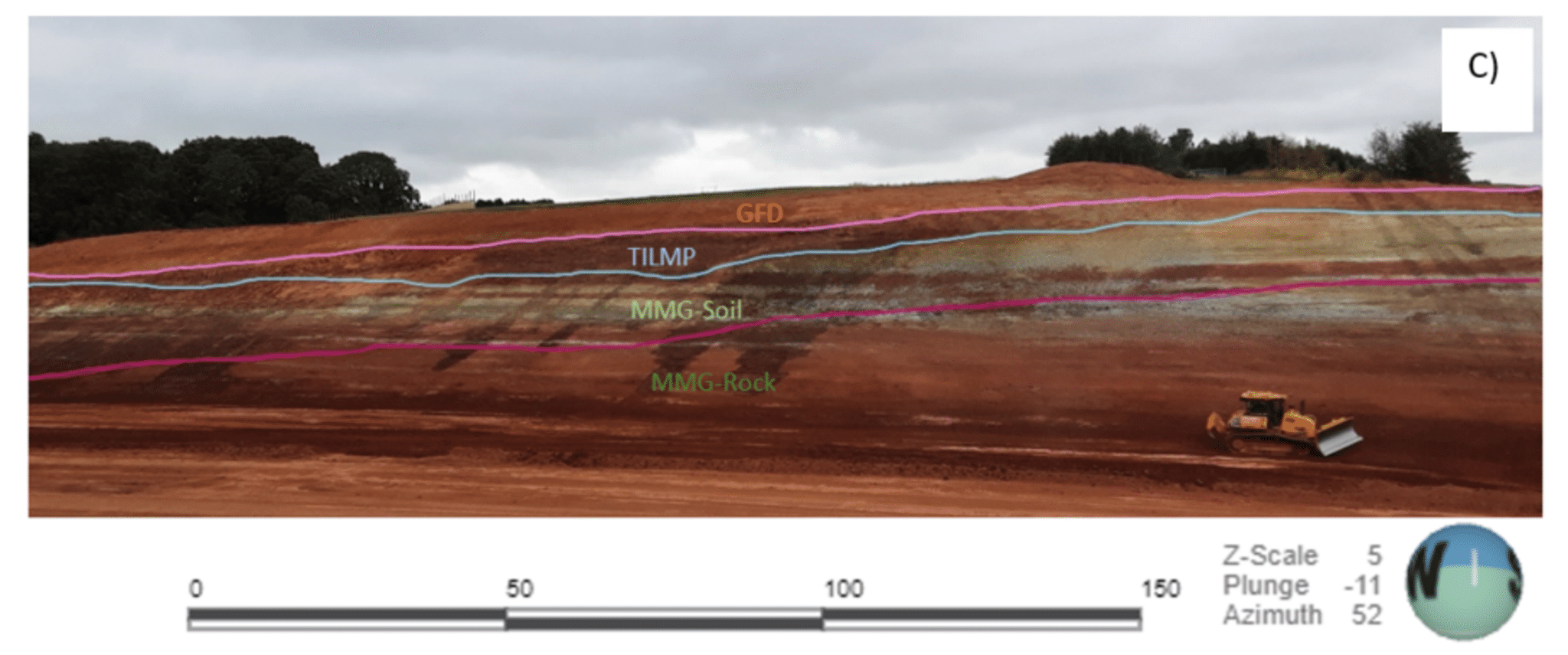
Conventional methods for assessing the suitability of reusing excavated material focus on a statistical review of ground investigation data compared to 2D specification of earthworks documents.
However, that method did not clearly indicate how material would be distributed across assets in 3D, which could introduce risks, inflate costs, and hamper carbon reduction efforts.
In addition to requiring a more accurate way to assess and plan earthworks, the project team needed to unify the work of large, multi-disciplinary teams working across many offices, companies, and time zones, as well as manage multiple phases of ground investigation with over 45 separate contracts.
Determining how to reuse excavated materials further lowered carbon emissions by reducing the need for importing new material to the site.
Bringing 2D materials estimations into 3D
The project team determined that the best way to optimise earthworks and greatly reduce the amount of material hauling was to create a new geoBIM assessment technique that used applications from Bentley and Seequent, The Bentley Subsurface Company, to integrate geological information and building information modelling.
To create the solution, they first connected the HoleBASE geotechnical database with OpenGround, which provided full interoperability with an array of design applications.
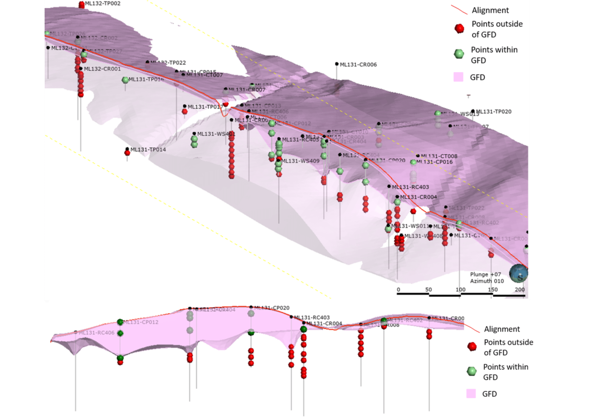
Next, they chose Leapfrog Works to undertake material reuse analysis, as it enabled the team to visualise ground investigation from all datasets in 3D, undertake dynamic 3D geological modelling and 3D statistical numerical modelling, and incorporate designs from OpenRoads and surface topography into the analysis.
Each analysis using Leapfrog Works produced a 3D geological model zoned by earthworks material reuse class prior to excavation.
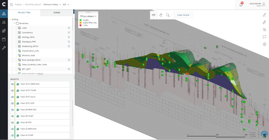
Lastly, the project team published the analyses produced by Leapfrog Works on Seequent Central, a cloud-based geodata management and team collaboration solution.
By using Seequent Central, the team could share data with all stakeholders, including real-time notifications and intuitive 3D views of all datasets.
With this method, stakeholders could see proposals for cutting sections through the topography and extracting material volumes. They also used Seequent Central to establish staged approval processes and a clear audit trail.
“The geoBIM technique can be readily applied to any infrastructure project that involves mass movement of material and is particularly beneficial when applied at the beginning of a project.”
Peter FairGeotechnical data and 3D ground modelling specialist, Mott MacDonald.
By optimising the excavation process, the team greatly reduced hauling resulting in significantly lower carbon emissions.
Optimising earthworks to reduce emissions
The project team used their Seequent and Bentley-enabled geoBIM technique on two pilot cuttings and immediately realised significant benefits.
The analysis clearly indicates where each type of material would be potentially encountered, helping the construction team optimise mass-haul movements.
“The construction team can optimise the mass-haul movements during the construction works through targeting specific excavations to obtain fill that meets the material class requirements for construction that is occurring elsewhere on the scheme,” Neville said.
As a result, they can prevent unnecessary stockpiling or additional material handling. Earthworks are further improved via more accurate volume estimations and the ability to model specific geometric earthwork profiles.
By lessening the need for material haulage, the project team has greatly reduced the emissions created by hauling vehicles and machinery.
Furthermore, teams can now maximise the reuse of material on site while minimising the amount of material deposited in landfills, lowering the import of fill material from outside the project area, and reducing the use of lime treatment, which results in further carbon savings.
The geoBIM analysis has so far been undertaken on over 50% of the material due to be excavated on Phase 1 Area North, helping HS2 to meet the goal of reducing carbon emissions by 50%.