


The mountains between British Columbia’s Highway 37 south of Dease Lake and the Alaska border have long been a prolific supplier of important mineral resources. Ten thousand years ago Canada’s indigenous peoples were accessing some of the world’s best obsidian – a natural volcanic glass sharper than surgical steel – from Mount Edziza and trading it all over the continent.
Fast forward to the 21st century. The bounty continues. This region can now boast two of Canada’s most significant copper, gold and silver deposits: Barrick Gold’s Eskay Creek Mine and NovaGold/Teck Resources’ Galore Creek Project. NovaGold alone has reported resources of 7.4 million ounces of gold, 117.1 million ounces of silver and 8.5 billion pounds of copper. And now thanks to a new deep imaging technique, Romios Gold Resources hopes to reveal even more in this rich paradise.
Romios Gold had begun intensively studying regional geologic maps which suggested the underlying rocks and mineralization between the two projects held serious promise and so in late 2004 began acquiring land positions there. Exploring surface mineralization supported their enthusiasm when it appeared the rocks may be closely related to the porphyry copper-gold-silver deposits at the nearby Galore Creek Project. They followed up with soil geochemistry, mapping and silt sampling programs on the Trek property in 2006.

Soon they had a diamond drilling program underway. “It was based on plain old hand drawn maps and geologic work,” says Scott Close, Principal Geologist for Romios Gold. “The very first time a drill hole was placed at the North Zone on Trek, we hit great breccia-hosted mineralization. This indicated we were within the cupola area of this porphyry so we expected the body to be nearby.”
Their hunch was right. Drilling successes in 2008, 2009 and 2010 discovered wide zones of gold-copper mineralization at the North Zone and also identified a new area of prospective copper-gold mineralization called the Tangle Zone. 2010 drilling results suggested the breccia and mineralization at the North Zone extended at least 700 by 550 metres, to a depth of 450 metres and – more importantly – it appeared that the mineralization may be traceable to a mineralized porphyry body beginning 550 to 600 metres depth.
So at this point what was really needed, before committing to further drilling, was a look deeper – beyond their drill depths, into where they expected that porphyry body to be. That’s when they brought in the Titan24 Deep Earth Imaging system. “With the Titan24 we could really get a good idea of where we sat,” recalls Close. “Predecessors to this system had imaged the Galore Creek mineralized body as we know it today, but the resolution was lower.”
The Titan24 Deep Earth Imaging is a product of Quantec Geoscience. Ron Vermey, Quantec’s President and CEO, describes what makes the system unique. “It’s a combination of array geometry,” he says. “We use a grid array on the surface that’s 2400 metres long, which gets us down to depths of 500 metres or more with IP (induced polarization, or chargeability) and resistivity, and 1500 metres with MT (magnetotelluric).” He says because of low signal strengths from such depths they also use highly sensitive electronics which can pick up very small signals. “That’s important when you’re looking at depth,” he says. The processing is important too, to recover small signals against an often noisy background.
The Titan24 system’s deep imaging capabilities were tailored for Romios Gold’s Trek property. And there was another attraction. “Quantec said they could actually couple their deep MT, their high resolution IP and resistivity – of which we hadn’t conducted in detail on any of on the Trek property – with drill results from portions of the surveys,” says Close. “So it was an excellent opportunity to do all three, allowing us to associate any anomalies, or lack thereof that appeared with data we already had and project into new territory.”
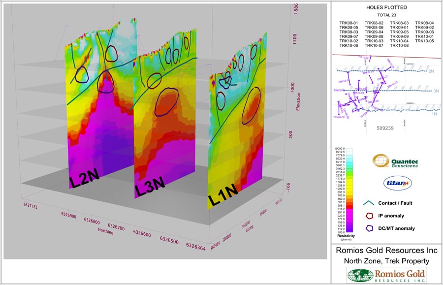
Undertaken in the summer of 2010 close on the heels of that year’s drilling program, the Titan24 Deep Imaging’s three lines revealed what Romios had suspected. The survey identified a large deep conductor 500 by 300 by 200 metres high, across all three lines in the Trek property’s North Zone; and it still remains open to the north, east and south. As Romios Gold says on its website, “this new feature, which lies east and below the previous drilling and occurs from 500 to 675 metres below surface, represents the main target for future drilling.”
The analysis and interpretation of the DC, IP and MT results also identified several chargeable anomalies above the deep conductive zone. They were reported to coincide reasonably well with the results of the existing 23 drill holes on the North Zone. Romios intends to drill test these anomalies in its upcoming program too.
Close describes the benefits that Titan24 brought. “It’s a highly sensitive system,” he says. “So it accurately reflects an interplay among the mineralization, alteration, structure and geology of the deposits; when coupled with different reference information like drilling or geochemistry, the survey provides a complete exploration picture.”
Quantec uses Geosoft Oasis montaj to generate all of Titan24’s sections and plan maps. The Geosoft Viewer allows Romios and other customers to easily view Titan24 maps, turn layers on/off as needed, and enables them to convert them into geo-referenced images for export in a vertical plane. They can bring these directly over into GIS and various other programs.
The mapping workflow was streamlined a few years ago when Geosoft designed a custom solution for the Titan24 application. A Titan24-specific menu blended seamlessly with Geosoft’s ability to import, view, process, and share data sets and images in one integrated environment. It allowed Quantec to produce client-specific presentations such as Titan24 Custom Inversion Sections and Plan maps, Voxel presentations and 3D inverted data. Vermey adds. “We’re able to efficiently visualize drillhole databases, create Titan 2D and 3D models, integrate client data and pseudosection displays for conventional data within one environment, for consistently high quality results.”
The inversion presentations were critical. “The regular DC-based inversion on the MT did a great job for the two southern lines, which indicated a conductor consistent with the geology in the area,” says Close. “Major faults overpowered the anomaly at depth on the northern line. So, applying a static shift upon the underlying resistivities to remove the influence of the overlying faults affecting this line, Quantec was able to identify the conductive anomaly striking through all three survey lines. Knowing the geology was useful for constraining the inversion.”
The final subsurface processing that brought it all together was produced using Oasis montaj. “The contouring inherent in Geosoft can histogram-equalize (evenly spread colors over a non-linear set of values) better than any other program I’ve ever used,” says Close, “so it makes incredibly beautiful maps.” He says once they had that image, they realized their drilling had just missed the conductive body. “The image confirmed what we had suspected: we had drilled smoke near the flame.”
Now, armed with this new deep picture, they’ve picked out new drill locations. “We will have one drill hole penetrate down the middle, right at the heart of the system, and verify the target,” says Close. “Then, we’ll step out. We will drill holes further to the east through the higher IP anomalies that coincide with surface mineralization, and trace the IP anomalies back toward the deeper MT target.” It’s a whole new level of confidence. “The Titan24 system has greatly enhanced our ability to focus our future drilling at these depths,” he says.
Vermey says Titan24 offers benefits because deposits are getting deeper. “As much as market economics say today ‘look for shallow deposits’, in many areas particularly in mature jurisdictions like North America many of the deposits are deeper, harder to find, or under cover,” he says. “So for ten years Quantec’s Titan24 method enables you to look almost as deep as you want to detect these ore bodies. In some places like Arizona you are looking down 1300 metres for porphyry copper.” And, he adds, with recent rises in commodity prices that certainly makes it economic to go back and re-explore old mines and camps. “Titan24 is a proven system in a mine site environment so you can come up with some good data out of what is normally a noisy environment.”
Romios used the Titan24 survey even in the absence of any existing drilling information – in the Tangle zone of their Trek property. They had nothing but a large soil anomaly, on which Close says “it’s hard to find funding to drill anomalous soils.” So they ran a single Titan24 line across the zone. It revealed a one-to-one correlation among all three DC, IP and MT surveys, exposing a deeper anomaly connected with the anomalous soils at surface. “That single line added enough confidence for us to attract investors to the potential of this new area,” says Close. “It brought us a wealth of possibilities. Really, to me, Titan24 is the new wave of ground geophysics.”