


A filtering process refined by inversion modelling has given Margaret Lake Diamonds (MLD) the confidence to select 12 drill targets from more than 60 geophysical anomalies on its 50,000 acre diamond property in the Northwest Territories.
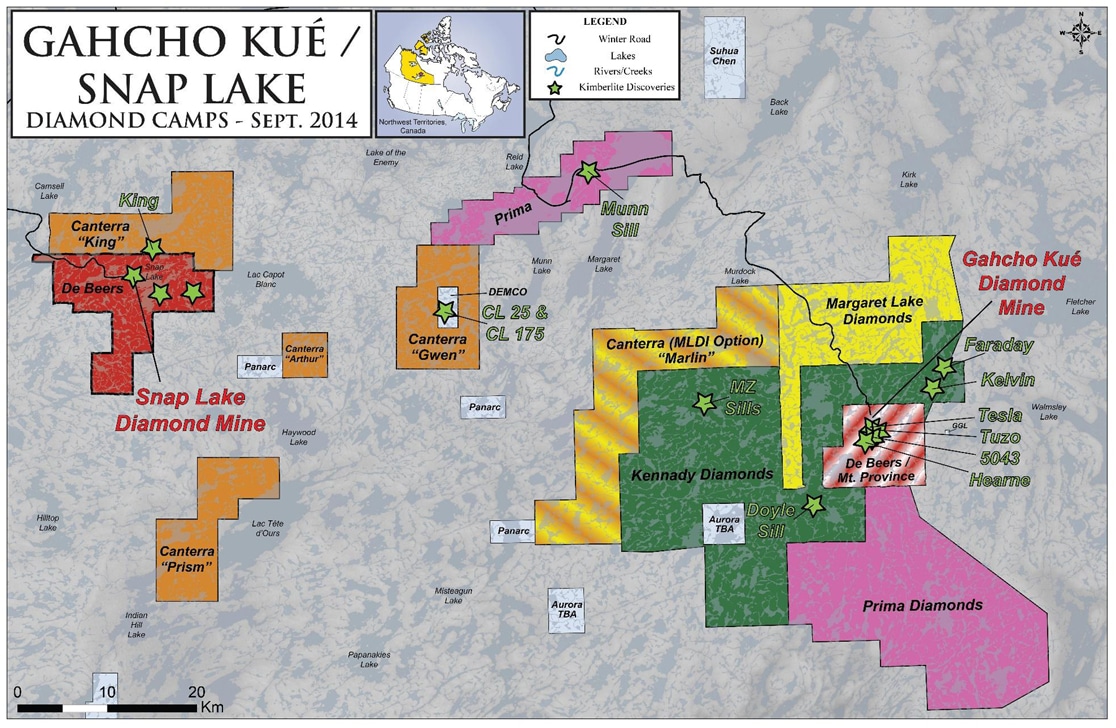
MLD is a relative newcomer to the diamond camp in the southeastern Slave geological province that hosts the Snap Lake mine, the Gahcho Kué project currently under construction and Kennady Diamonds’ bulk sampling and advanced exploration projects. President and CEO Paul Brockington, a Kennady shareholder, first heard of the Margaret Lake property in 2013 while in London chatting with a former classmate from the Camborne School of Mines. The mining engineer recognized the potential of the underexplored claims immediately.
“The claims were staked by a private British group in 2011, but their primary interest was tin and they devoted no time to the diamond property,” says Brockington, who used $100,000 from privately owned Harsbo Minerals to keep the claims in good standing and then vended the property to MLD. “I met with my lawyer in Vancouver on the Friday night, flew to London on Saturday and closed the deal in a hotel room on Sunday night.”
In order to earn a 60% interest, MLD had to spend $1 million on the property by October of this year. The company flew a HeliFALCON survey incorporating gravity (AGG) and magnetics over 2,800 line kilometres at 75 metre line spacings. To correct the gravity data for water depth, the company ran a property-wide bathymetry survey using Worldview2 high-resolution satellite imagery.
Though bathymetry is commonly used to correct gravity data from the lakes dotting the Northwest Territories, the measurements are usually taken at lake level from zodiacs. By acquiring satellite data, MLD was able to process the gravity data immediately, instead of waiting several months for data collection from the lakes.
(Because most of the lakes on the Margaret Lake property are shallow, MLD believes the satellite imagery is an accurate rendering of the bathymetry, but measurements in the deeper lakes may warrant ground confirmation.)
Unlike the pipes in the Lac de Gras camp to the north, the area’s kimberlites tend to be highly eroded by glaciation leaving irregular dykes and sheet-like structures that represent the root and diatreme zones of the pipe. Their emplacement is believed to date back to the Cambrian Period about 540 million years ago.
To narrow down the 67 geophysical anomalies resulting from the HeliFALCON survey, consultants Campbell & Walker Geophysics used all the information they could gather to rank targets, including historic geophysical and geochemical results from ground surveys. Of the 67, eight were based solely on their magnetic response and eleven on previous geophysical data in the assessment files that was confirmed by the 2014 AGG survey. The remaining 48 were based on a combination of their AGG and magnetic responses.
The consultants assigned a rank of one (highest) to four (lowest) to each of the 67 anomalies based on its geophysical and geological (e.g. proximity to indicator minerals) character. None of the anomalies received the highest ranking, but there were 37 in rank 3 and one in rank 2.
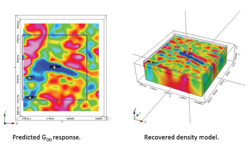
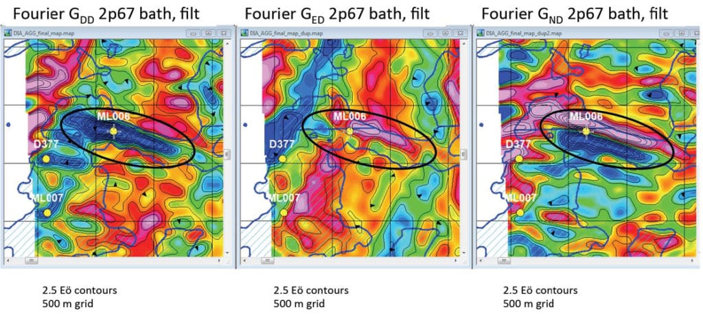
After further review, the team selected five Priority A and 17 Priority B targets for inversion modeling using Geosoft VOXI. The model included the Fourier-processed tensor GED, GND and GDD components of the gravity gradiometry data and incorporated magnetics where applicable.
“We made an initial decision to model – or attempt to model – all the geophysical targets we deemed as priority A and B on the premise that if we couldn’t derive a geophysically and geologically coherent model from our data, then we probably shouldn’t be drilling it, at least not without further ground-based evidence that the feature may indeed be kimberlite prospective” says geophysicist Kit Campbell.
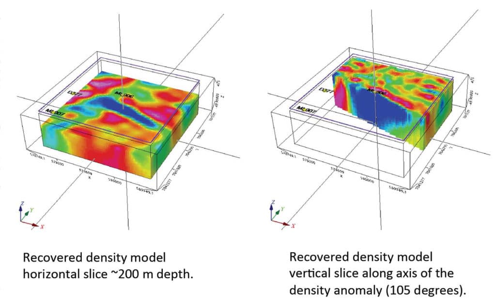
They viewed and imaged the results in 3D along with the high-resolution satellite imagery and physiographic vector data, allowing them to optimize the drilling program both for ice-based vertical holes designed to test the root of the kimberlite and for angled holes from land.
“In both cases, we were targeting the maximum physical contrast mass of the selected anomaly.”
The next step for MLD is to correlate the results of a till sampling program from areas where there is a combination of historic geophysics and indicator minerals with the recent geophysics to derive the final target selection.
MLD has applied for a drilling permit and Brockington hopes to begin drilling the lake-covered targets next winter. The goal is to collect a large enough sample of any kimberlite the company might intersect (a couple of hundred kilograms) in order to complete microdiamond analysis.