


Expert Geophysics Limited’s latest innovation MobileMT is making waves in airborne surveying and exploration.
What if you could see deeper into the earth, even in difficult terrain, to better pinpoint and understand the distribution of resources?
“Our unique Mobile Magneto Tellurics (MobileMT) technology overcomes many current industry challenges to help deliver just that,”
says Alexander Prikhodko, Vice President and Chief Geophysicist of Expert Geophysics Limited.
The company, based in Ontario, Canada, started in 2016 and specialises in airborne surveys for global clients across the mineral, oil and gas, and geothermal exploration sectors.
Demand to discover critical minerals and support the clean energy transition (such as geothermal energy and carbon capture and storage) brings more urgency to explore mineral systems globally.
To do this, geoscientists now need to look much deeper – often up to 1 kilometre or more – with geophysical surveying playing a key role in this type of exploration.
MobileMT offers a brand-new way to collect electromagnetic (EM) survey data with the most advanced generation of airborne AFMAG (Audio-frequency Magnetic) technology, based on exploiting natural electromagnetic fields.
“Together, with the data processing power of Seequent’s Oasis montaj, we can now better understand what mineralisation we are seeing several times deeper than using an alternative survey technology,”
says Alexander. “And help exploration geologists better strategise where potential targets could be.”
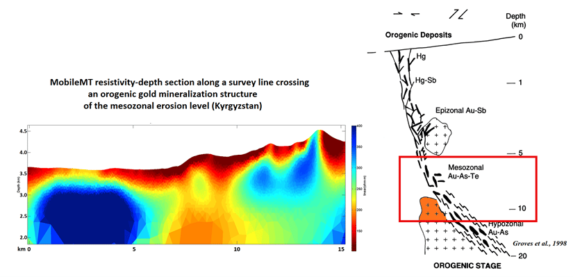
MobileMT technology can see deep underground to help better understand mineralisation deposits and their endogenetic controlling structures.
The power to see deeper
Since their MobileMT technology was introduced in 2018, the company has flown more than 70,000-line kilometres, to collect data.
“Simply put, our job is to fly the survey, gather data, and process it,” says Aamna Sirohey, Data Interpretation Supervisor at Expert Geophysics.
“We have many clients looking for very different things,” says Aamna. “The value of this technology is that we can achieve consistently good results across very diverse conditions and surface topography.”
“MobileMT fills a gap in the market because we can survey geology at geoelectric and terrain conditions that previous systems could not,”
says Aamna. Energy limitations (for airborne electromagnetic systems with controlled source transmitters) escalate over complex typography because it is difficult to maintain close ground clearance during flight.
“In any terrain conditions, we can fly safely above ground while still maintaining a robust response, which is extremely helpful in highlands.”
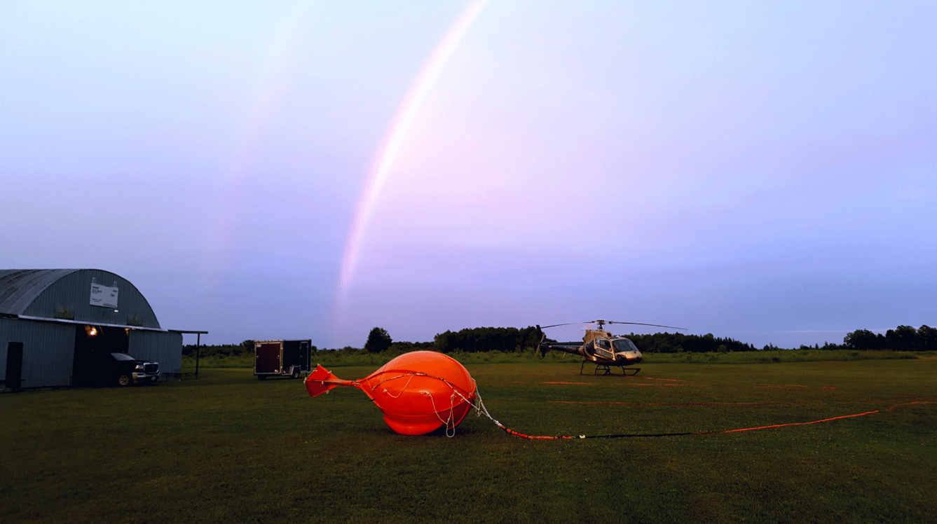
An airborne receiver towed by a helicopter exploits natural EM fields from global lightning and thunderstorm activity (that cause variations in the earth’s magnetic field).
“In both conductive and resistive environments, we can explore deeper to see more and help deliver superior investigation results,”
she says. “From an exploration point of view, this is very valuable because we’re looking to find the factors that control mineralisation – often only visible from several hundred metres below ground.”
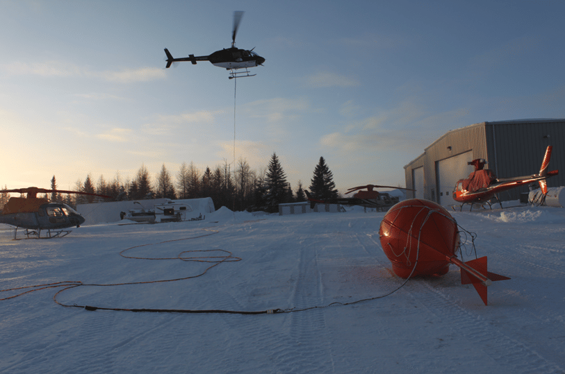
An airborne receiver towed by a helicopter can deliver superior exploration results even in difficult terrain.
Better navigate complex challenges
Alexander has worked in airborne geophysics data processing and interpretation for over twenty years.
He understands the significance of now having MobileMT agility to help navigate challenges in topography and geology.
“But to help our clients meet their mining and exploration objectives, we don’t just measure physical fields,” says Alexander. “We also provide 2D sections, depth slices and 3D models to support their planning visually.”
Airborne survey data is transformed into better decision-making with the help of Oasis montaj subsurface mapping software.
It’s a powerful way to visualise data – allowing different data sets to be combined to make the best use of all available data.
Aamna, who has worked with Expert Geophysics for a year, was new to airborne geophysics but is fast becoming an expert in the field.
“Most of our data processing and 2D-3D visualisation is in Oasis montaj,” she says. “It’s our go-to industry standard when working with high-volume data from diverse environments.”
Extended data processing power
Oasis montaj can easily integrate all geoscience data and process complex data with ease.
“Another advantage is the simplicity of having everything centralised in one place rather than using separate software to map or visualise GIS data,”
says Aamna. “It’s flexible and easy to use, provides great context and intuits your expected next steps,” she says.
“With the benefits of interoperability between other Seequent 3D modelling solutions, such as Leapfrog Geo.”
Every project is unique and there are options to add on specific tools and workflows with over 25 geoscience data extensions.
“With the Geophysics Levelling extension, we can pull more details from the data to generate fuller insights and help our clients better understand the geology,” says Aamna.
Alexander appreciates how quickly Aamna is learning and can process the enormous airborne survey data sets and the efficient turnaround for their clients.
“Every day, we can have up to seven or eight geophysicists working with the software – so we always think of Oasis montaj as one of our valued employees!”
says Alexander.
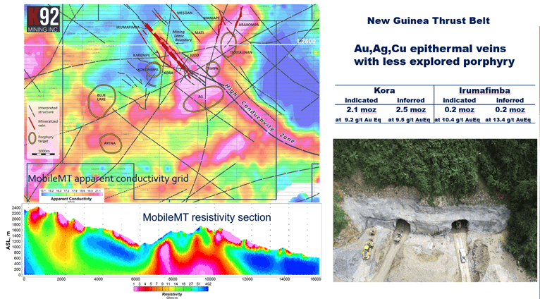
MobileMT technology explores new targets and extensions of known mineral deposits in Papua New Guinea.
Innovation for more global discoveries
With its depth of investigation and wide range of frequencies, MobileMT has experienced a rapid universal growth in exploration.
The Expert Geophysics team have completed more than 70 projects across Canada, the United States, South America, the Middle East, Asia, Indonesia, and Australia.
“Our clients have discovered many new places for test drilling and further exploration,”
says Alexander. “And because the technology has a wide range of detectable resistivity differentiations, we can also work in both, highly conductive and highly resistive environments.”
A great example is an exploration project in Papua New Guinea using MobileMT.
“The island is very conductive with rugged relief, and it hasn’t been easy to collect useful information with controlled energy airborne EM systems in the past,” says Alexander.
“With MobileMT we were able to carry out the first survey on the island for 15 years to explore new targets and extensions of known mineral deposits better.”
For exploration in porphyry, orogenic, epithermal and stratiform styles of mineralisation the technology has been able to recover the mineralisation controlling structures not visible before.
“We’re excited to see where our MobileMT technology takes us and what it may enable us to see,” says Alexander.