


Visualize, analyze, and integrate your geophysical data, from Oasis montaj, in Leapfrog via the new geophysical extension.
Using the geophysics extension geophysical voxels and grids can be imported into Leapfrog, where data integration is made possible through the creation of numerical models of the geophysical data using the new IDW grid interpolant (geophysics extension). From the geophysical numerical models, isosurfaces of interest can be integrated into the geological model, as a lithologic units, allowing further analysis and interpretation of the geology.
Overview
Speakers
Laura Quigley
Geophysicist, Seequent
Duration
3:44 min

See more on demand videos
VideosFind out more about Seequent's environmental solution
Learn moreVideo Transcript
[00:00:00.655]
(bright music)
[00:00:06.920]
<v Instructor>In this video, I’m going to show you</v>
[00:00:08.530]
how to integrate your data between Leapfrog
[00:00:11.210]
and Oasis montaj.
[00:00:13.600]
Interoperability between Oasis montaj
[00:00:16.430]
and Leapfrog allows you to use your geophysical information
[00:00:19.840]
to inform your geological model.
[00:00:23.710]
You can leverage our new geophysics extension
[00:00:27.000]
to seamlessly visualize, analyze,
[00:00:29.140]
and integrate different formats of geophysics data
[00:00:31.690]
into Leapfrog’s intuitive workflows
[00:00:34.140]
to refine and optimize geological interpretations.
[00:00:39.564]
In this example of the interoperability,
[00:00:42.100]
I will use data from an airborne frequency domain EM survey
[00:00:46.070]
collected over a large area in Nebraska.
[00:00:49.610]
The airborne EM data can be utilized to constrain
[00:00:52.210]
the extents of the groundwater aquifer
[00:00:54.300]
that is known to be in the area.
[00:00:57.480]
Our geological model created in Leapfrog Works
[00:01:00.350]
was constructed from borehole data,
[00:01:02.400]
which is sparse in the area of the known aquifer.
[00:01:05.450]
So the geophysics will provide a much higher resolution
[00:01:08.190]
of the subsurface in this region.
[00:01:11.080]
Most importantly, we can use the geophysical data
[00:01:13.500]
to inform our geological interpretation
[00:01:16.170]
and plan further drill holes to constrain the aquifer.
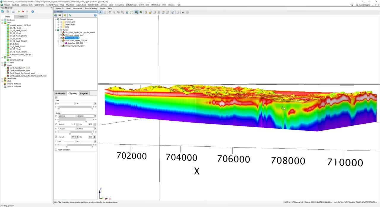
[00:01:21.020]
In Oasis montaj, I have inverted
[00:01:22.760]
the geophysical airborne EM data,
[00:01:25.440]
which is a frequency domain survey
[00:01:27.480]
spanning a depth of exploration to about 100 meters.
[00:01:32.610]
The inversion was done in VOXI,
[00:01:34.600]
which is Seequent’s, on-demand cloud-hosted forward modeling
[00:01:37.820]
and inversion service.
[00:01:41.010]
In VOXI, the data is processed in the cloud,
[00:01:43.550]
leaving your computer resources free to do other tasks.
[00:01:47.320]
We can export our voxel to a UBC model,
[00:01:50.400]
which can easily be imported into Leapfrog Works
[00:01:53.560]
via the new geophysics extension.
[00:01:57.430]
This will allow you to filter
[00:01:59.040]
and visualize your data in Leapfrog.
[00:02:04.370]
Furthermore, we can use this geophysical data
[00:02:07.090]
to create a numerical model of the aquifer.
[00:02:10.600]
This is done through our new, IDW isosurfacing
[00:02:14.460]
in the geophysics extension.
[00:02:16.660]
Imported geophysical grids can be isosurfaced
[00:02:20.070]
using the local IWD Isosurfacer.
[00:02:23.470]
This allows for faster and more complete integration
[00:02:26.080]
of geophysical data into the context of your 3D model.
[00:02:30.720]
Once we have our surface, or surfaces of interest,
[00:02:33.940]
we can then begin to incorporate this information
[00:02:36.460]
into our geological model.
[00:02:38.540]
I can add a lithology to my model.
[00:02:42.690]
And I have called it aquifer.
[00:02:45.670]
I can incorporate my aquifer
[00:02:47.190]
into my geological model as a new intrusion.
[00:02:51.510]
So this is done in the surface chronology folder.
[00:02:55.120]
Once I have added this and selected it,
[00:02:58.050]
my geological model will update to include this unit.
[00:03:02.600]
Once the geological model is run,
[00:03:04.190]
I can see my aquifer in relation to the geology in my model.
[00:03:08.770]
This can be used to interpret your geology
[00:03:12.200]
and further plan drill holes
[00:03:14.660]
that can be used to constrain the aquifer even further.
[00:03:18.690]
So this is an iterative process,
[00:03:21.140]
also with our new geophysics extension in Leapfrog,
[00:03:24.550]
we are able to import crooked grids or crooked sections.
[00:03:29.010]
So this will also aid in the interpretation
[00:03:31.340]
of your geological data.
[00:03:39.252]
(bright music)