


For any transportation project it’s essential to have a clear view of the subsurface and any problems that may arise. What ‘lies beneath’ will invariably have a major impact on project progress and budget adherence – and geotechnics has a key part to play in revealing it.
Contributors to this article include recent speakers at Seequent’s Lyceum 2021. Speaker Ray Yost, Principal Geotechnical Engineer, Advisian discussed ‘Understanding geotechnical risk: A structure for uncertainty.’ And a panel of industry thought leaders from Mott MacDonald, DB Engineering and Arcadis, discussed the benefits of digital ground modelling and how it has improved project outcome and what still needs to change in the near future. 1 2
Reducing geotechnical uncertainty in turn increases project certainty and decreases the risk of delays and expensive budget overruns. Being able to incorporate new information in near real-time can also be invaluable in accelerating delivery and cutting costs.
Innovation and digital transformation have a major role to play in bringing the subsurface and surface together. Together they can help deliver sharper insight, make short work of common problems, maintain the highest of professional standards and provide an encyclopedic resource for the whole lifecycle of structure.
From planning and investigation, through design and construction, to operation and maintenance, each stage requires the analysis of geotechnical risk. And as climate change presents us with unprecedented environmental challenges, technology is a lever we can pull to help us meet them and drive essential infrastructure projects forward.
So, how can we make that happen and what are the obstacles in the way? Here are eight points to consider.
1) Understanding the rules of geotechnical risk
Geotechnical engineers are often dealing with small data sets – whether small in value or sample to volume ratio – and this adds to the uncertainty. The properties of geomechanics are inherently variable and difficult to obtain, which adds to the uncertainty. How then can we properly understand geotechnical risk?
Ray Yost says it’s about allocation and audience. “When thinking about the allocation of resources there is a structure to uncertainty. There the tools that we have as geological engineers to help us think about that. And when we start to marry the circumstances of uncertainty and the tools we have for addressing it, we really want to ensure it produces an optimal allocation of resources.”
Ray characterises risk as a function of the relationship between uncertainty and proposes a framework that matches tools to risk character in order to improve risk assessment outcomes.
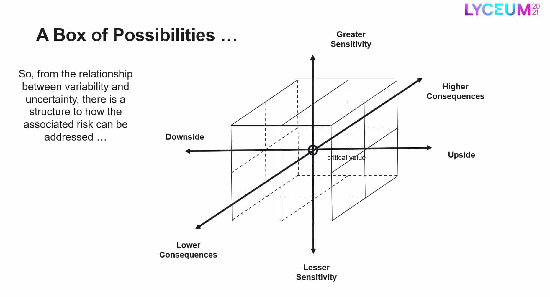
Figure 1 – looking at risk as a function of uncertainty.
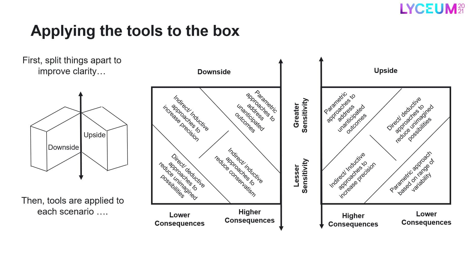
Figure 2 – Applying the tools to the box.
“And when we talk about uncertainties with our model we have to talk about risk in terms of what impacts the audience. For instance, if it’s mining engineers, you’ll talk about impacts on their schedule, production, access, budgets, income streams. The first rule of communicating geological engineering is don’t talk about geological engineering.”
“The first rule of communicating geological engineering is don’t talk about geological engineering!”
Just as there’s a cost associated with the downside of unmitigated liability, there’s an opportunity cost associated with the upside consequences, Ray comments, “We could have had leaner and meaner construction, we’ve dedicated resources that we didn’t need to.”
2) Better communication, better collaboration, better outcomes
This is where digital innovation is already helping in ground engineering. Ground conditions are increasingly being incorporated into the BIM environment, strengthening collaboration and improving outcomes from tendering to in-project coordination and material reuse. For example, the tendering process is simplified when contractors have detailed information about soil and rock volumes. Bernd Heer, Senior Geotechnical Consultant at DB Engineering & Consulting GmbH, notes that, “During the production and conception process, there is less discussion with the contractors (on the interpretation and assumptions of the data), which helps the project in general.”
Enabling soil property information to be analysed and visualised in 3D improves the understanding of the data and also the communication with the wider project team and stakeholders. Peter Fair, Geotechnical Data & 3D Ground Modelling Specialist, Mott MacDonald UK, notes that, “being able to analyse the Earthwork Material test results and compare that with the directly with the geological model directly within the BIM environment adds real value. One of the really key benefits is it now allows us to see not only the percentage and volume of the different materials but how easy it’s going to be to excavate and ability to be reused. We can see and understand that now much easier within the 3D model.”
3) As climate change worsens, we must react faster to save infrastructure and lives
Geotechnics and the role of civil and environmental engineers will increase substantially as climate change impacts and mitigations become more apparent. After all, we work in the environment; it’s where our structures exist.
Technology is an important lever we can pull to help us face these environmental stresses and strains. The ability to understand the ground through sophisticated 3D modelling and being able to see it rapidly with, for instance, a deployment of a drone, means it’s possible to see a slipped cutting or embankment and not have to wait for a topography survey. As Peter Fair, Mott MacDonald UK, puts it, “When we have digital assets we can respond quicker, information is at our fingertips and we can make data driven decisions and respond in a more informed way.”
As data from the plethora of deployed sensors (the internet of things) becomes more usable, it can help us get ahead with managing and mitigating climate change. Bernd Heer, DB Engineering & Consulting GmbH sees huge potential in this approach, informed by his experience of the catastrophic 2021 German floods that completely destroyed infrastructure. “If we have weather prognosis systems and we combine this with what we know of the terrain, sensors can actually talk to our structural assets. I can then envisage that the structure puts out warnings about what’s going to happen within set parameters.
“Even if we can’t save the infrastructure itself we can save human lives.”
4) The more you know, the leaner you can design
Digital workflows can lead to a leaner design resulting in lower environmental impact, explains Andrea Gillarduzzi, Technical Director, Geotechnical Engineering, Arcadis Consulting (UK) “If we start using BIM and digital tools in a cleverer way, we would be able to obtain much more significant data about the real range of behaviour of the infrastructures and that might result in a more economic design. We would be able to maintain the infrastructure in a more effective way…. that has less impact on the environment.
When you obtain the data, you would not necessarily know all possible ways it might be used for, but if you’ve got it you can decide.” As Seequent’s Gareth Crisford, Regional Head of Civil, Environment and Energy, EMEA, puts it, “If you use all the data you have and have a custom maintenance system on the asset, you can look back over the asset’s life and see how it could have been designed differently and leaner; this leads to a continual cycle of learning.”
5) Infrastructure assets are already talking to us. Are we listening?
The move to the Internet of Things is, of course, well underway, with seemingly countless sensors collecting data in any manner of different ways. In fact, the mountain of data they are collecting is daunting. For decades Infrastructure assets have been installed with these sensors, with also the potential to retrofit them, but probably only now it is within the industry’s grasp to use the data more extensively.
Andrea Gillarduzzi says, “The present technology is going to use this data in a more effective manner to transfer the information rather than it being owned by a single project or single entity.”
Bernd Heer explains, “There’s a midterm effect, in the next five years, where we’ll learn to integrate the available data much quicker. For me this is mostly in the design phase, where we can start doing automated foundation design.”
6) How could life change for the geotechnical engineer in this new era?
Will it mean a significant shift to more of a curator of results that have been automatically gathered by sensors and different systems from historical sources?
Bernd Heer can see this, “We as geotechnicians will only look, curate and validate data before it gets put into the system. There will be a lot less report-writing, a lot less checking for drawings, a lot less setting up meetings, talking about what that actually means because we will all agree on the available data.”
“There will be a lot less report-writing, a lot less checking for drawings, a lot less setting up meetings, talking about what that actually means because we will all agree on the available data.”
And as data is coming from different independent sources this will also help with validation. As Andrea Gillarduzzi explains, “If you are monitoring an expansion joint of a bridge, and you combine it with meteorological monitoring, and with traffic data over a given period, you may get to understand better the wear of the joint, design and maintain it differently and so on. Lots of data can be easily obtained by embedding sensors and other tech in what we build or by retrofitting it.”
As outlined, much of this is already underway with data being actively recorded but not yet extensively used. For example, the torque used by a drilling rig can give information about the strengths of the rock and soil.
Peter Fair sees the potential for bringing the data gathered on drilling rigs into the design process. “We’ve done an initial design, and then we’re onsite drilling, and using that data in a way that can directly influence the design almost as the asset’s being constructed. And then longer term, with AI, I could see that we use that data for automated design and we become the checkers and approvers of an automated design. We’re starting to see that now with CPT assessments where the AI is doing better assessment and making less errors than some of the human resources.”
7) Is the industry ready for automated design?
Automatic design is already happening in other areas, particularly for linear jobs, for example drill and blast. We effectively position the drilling holes for the best position to obtain the best rate of production, the safest production, and avoidance of over-excavation, over-profiling.
But a leap to automated design will require significant thought change within the industry, adapting design during the construction process will for instance have implications for regulation.
Bernd Heer comments, “Within the civil engineering community in Germany the design has to be checked and approved by the states and local government. So, you have to provide an automated circle system that actually repeats that approval very quickly, so you can adjust the design onsite. It’s a big step for everybody involved in the industry, and we have to walk that way, but we’re not there yet, at least not here.”
8) The importance of standards vs the willingness to share…
International standards, like ISO 19650, are already improving the digital project with the organisation and digitisation of information about civil engineering works, including BIM. A single model provides a single understanding but we’re still facing a challenge as an industry over the transfer of data and the definition of ownership and the liability attached to it.
Andrea Gillarduzzi comments, “At present, we are faced with a concern that sharing data increases our liability, and this discourages collaboration between the different parties, and is something which I believe we need to overcome as soon as possible before we lose an immense opportunity.”
There’s also the issue of data not being collected or saved. But just collecting the information, making sure it’s stored in a reusable way is key, with ISO 19650 enabling us to keep reaching towards it.
And although we’re in a data age we have to consider whether for some assets it’s worth the cost of data storage. For critical infrastructure there’s no question but is this the case for every single asset? And keeping the data updated is another important consideration adding to the systemic challenges the industry needs to define and agree, what to save, what not to save and what is the liability, exposure and risk during a project. And when models are passed on from one consultant to another, how do we ensure that it is able to be used by the ongoing consultant?
Peter Fair comments, “So often we don’t have the assurance of that model. And then as a consultant, we feel that we have to rebuild that model from scratch just to prove to ourselves that it is of the required level, and that seems to undermine all this.”
And yet we share what we consider to be factual data, but any ground model is inherently an interpretation. And so, in many respects when we share a model we already share a liability and we need to acknowledge that.
Technology can help to overcome subjectiveness, for example scanners for a solid core of rock, are not just optical but X-ray or colour infrared, squeezing even more data from the source. And there is a lot of new technology, which in future, will help us to get a more rounded experience of what happens in the field, with augmented reality, fully immersive VR and so on bringing a new layer of multi-sensory data which is presently completely disregarded.
There are obstacles, but they can be overcome
And there are, of course, many obstacles to the introduction of advancing technology.
- Software providers are often criticised for being proprietary and not open to all users.
- Then there is the steep learning curve in keeping up with technology.
- We face the very real risk of a disconnect between the tech savvy young and the older more experienced generation with 20-30 years of valuable knowledge and experience under their belts.
- And to be successful, digital has to be all together, with no one left behind.
Some very meaty challenges lie ahead for the industry. As Gareth Crisford says “We’re on a continual journey where we’re trying to be open to all. Openness and interoperability are driving forces within Seequent, it’s our life blood. For instance, we’re currently developing open APIs into our cloud repository, so we can help leverage all the best-in-class new geotech technologies out there. We’re known for our ease of use and data openness and we’re ready to help geotechnical engineers face the challenges of the future.”