


Create better models with a new generation of easier and more intuitive Cloud-based software bringing the power of geostats to more people.
1) Easily capture uncertainties. Build better, more accurate models.
Can geostats improve my models?”
“I’m no expert, can I use geostats?”
“Can geostats characterise risk and uncertainty?”
These are some of the top questions asked about geostatistics. And the short answer is: “Yes!”
So, what exactly is geostats?
“It’s a suite of statistical algorithms to work with spatial data,” says Alexandre Boucher, Advanced Resources and Risk Technology (AR2Tech), part of Seequent.
Simply put: It’s probability.
“Algorithms capture geological patterns from the data to create alternate 3D models of the subsurface,” says Alexandre.
A more accurate evaluation means a better understanding of a project’s potential or risk, crucial to good decision-making.
“What’s the likelihood a mine extension will be profitable?” or, “Could this contaminant reach a water supply?” are examples Alexandre offers.
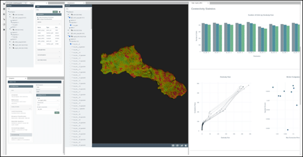
Design features of the AR2Tech platform maximize the value of conditional simulations with dashboard, data science and 3D visualisation.
2) Let the numbers speak. On the same page in the Cloud.
Strike up a conversation with a non-geologist about Ore distributions across a mining operation and they may not know what you mean.
However, if you talk probability, “There’s a 40% chance of hitting clay here,” or, “We’re likely to find gold at this depth,” and they’ll understand. That’s geostats in action.
“Allowing the numbers to speak gives everyone a clearer picture of a certain scenario, even if it’s one they may not be familiar with,”
says Ignacio Torresi, solutions director, geostatistics at Seequent.
Where geostats connects the dots, Cloud connectivity makes the information accessible.
“Improved processing capability in the Cloud provides a path to better investigate and collaborate on today’s complex earth challenges,” says Ignacio. “And the ability to crunch large amounts of data from anywhere – from home, a site, in the field or at the office.”
If the Cloud provides a high-performance platform where people can work together with more flexibility to make critical decisions faster, what happens when we add the intelligence of geostatistical algorithms?
“We’ve got something more powerful, efficient, reliable, accurate, and accessible,” adds Ignacio.
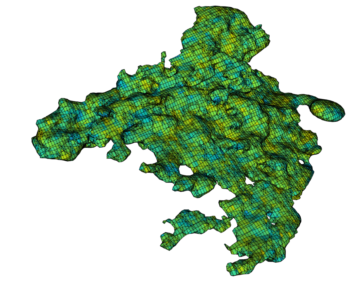
Using ARTech unstructured grid technology, the grade of a complex ore body can be simulated with sub-blocked cells that are fully conformable to the wireframe.
3) Machine learning. Automate mundane tasks and improve consistency.
Ask five geo-professionals for one interpretation of a dataset and you may get six answers! The real challenge in data interpretation is often consistency.
In a geomodelling context, machine learning (ML) is the ability of a computer system to better predict accuracy and make decisions (typically done by a person) to create subsurface 3D models.
“This increases productivity by automating repetitive tasks and can even lead to the discovery of unknown data relationships that may have escaped an experienced modeller,”
says Alexandre.Geostats are an essential component of any subsurface ML system, enabling better reproducibility and consistency over manual interpretation.
“Similar to machine learning, algorithms can capture the geological patterns and relationships from data samples and use the patterns to combine all information in a suite of high-quality models,” says Alexandre.
Automation essentially frees up time to focus on more impactful work, complex problem solving, or creative solutions.
4) Turn geology into numbers. Anyone can do it, everyone can understand.
Geostats bridges the qualitative world of the geologist with the quantitative focus of engineers and decision-makers.
Simplifying geostatistical algorithms bring their use within the reach of non-experts.
“Access to the latest technologies means the level of geostats knowledge expected is greatly reduced without compromising high-quality models,” says Ignacio.
3D models show all relevant geological information in a numerical form that can be easily translated into, for example, water contamination levels or grade-tonnage curves.
“The exploratory work of geologists become metrics that other disciplines, such as geo-engineers or non-geo stakeholders, can more easily understand and take full advantage of,” says Ignacio.
“It’s similar to what Leapfrog does in implicit modelling today – building trust with the user who then starts trusting in the discipline too.”
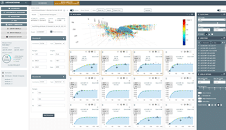
Leveraging machine learning algorithms, AR2Tech software can dramatically improve user productivity for difficult tasks such as variogram modelling.
5) User-friendly software. Bringing the power of geostats to more people.
Geostats is the engine behind a new generation of easier and more intuitive software from AR2Tech.
By joining Seequent, AR2Tech brings state-of-the-art geostatistical algorithms to the mining, civil, energy, and environmental geomodelling communities.
“We’re currently researching and working with Seequent to create powerful, new modelling algorithms and workflows that leverage the latest technologies and computing resources to build faster and better subsurface models,” says Alexandre.
Alexandre started AR2Tech in 2010 following an extensive academic career studying and teaching geostatistics.
“As a student, when I discovered a subject that combined computer mathematics with geology – I was hooked!” he says.
“With the use of statistical analysis in geomodelling people can learn so much more about their world.”
That’s a better understanding of everything from protecting the environment to resource distribution, or contamination to engineering wind turbines.
“Natural resources are in high demand,” says Alexandre. “With geostats as an accessible tool across industries, we can make more connections between what’s available and what’s possible in our fields.”
Geostats as an opportunity to elevate business and careers.
As the link between geoscience and engineers narrows, geostats are becoming crucial to help better design the solutions and innovations to meet the demands of tomorrow.
At the core of geomodelling, they open the door for automation and more consistent auditing of subsurface models to enable improved workflow across multiple scenarios.
The bottom line is that geoscientists understand geology. As global challenges become more complex being able to turn geology into metrics for easier communication and decision-making, is key.
“Not only will leveraging AR2TECH technology make a big difference to our solutions portfolio,” says Ignacio. “It also validates to our customers that as an organisation we have an eye to the future and want to lead and remain disruptive in what we do best – 3D earth modelling.”
This opens up new opportunities to expand expertise and advance careers for geomodellers and engineers alike.