


When France’s Areva, the world leader in technological solutions for nuclear power generation, acquired UraMin in mid-2007, the Canadian company was a junior success story.
UraMin had picked up some low-grade concessions in Namibia near the huge Rossing mine when the uranium price was still relatively low and proceeded to build its African portfolio. A rising uranium price made those acquisitions increasingly valuable and attractive to Areva, which was looking to diversify its resource base and secure longterm uranium supplies.
Renamed Areva Resources Southern Africa, the new subsidiary is expected to provide Areva with 7,000 tonnes of uranium per annum by 2012. Starting later this year, production will come from three main deposits: Trekkopje in Namibia, Bakouma in the Central African Republic and Ryst Kuil in South Africa.
Today, Areva South Africa has an impressive portfolio of exploration projects throughout the continent that are benefitting from Areva’s rare combination of expertise in uranium deposits and African exploration.
But while project diversity is a blessing in exploration, it can also create data management challenges. In 2007, the company recognized it needed a better way to handle and share its exploration data to improve productivity and ensure project managers had access to the best available information.
Typical of many global mining companies, Areva’s exploration geoscientists used several different software packages with no efficient way to integrate or share their knowledge and information. Meanwhile, the company’s data managers were getting bogged down with incoming data that – with the right tools and some training – the geoscientists in the field could manage. And visual presentations to the company’s decision-makers were not as clear and comprehensible as they could be.
They partnered with Seequent to take a more strategic approach to Exploration Information Management that would establish a complete technology solution and new standards for managing and effectively using all their exploration data assets in South Africa.
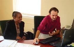
Olivier Masset, Manager of Resources and GIS, and Nozuko Mani, GIS Manager with Areva South Africa, led the needs assessment and business strategy for the exploration technology initiative.
“We were spending a huge amount of time in data handling, manipulation and QC and we wanted a streamlined system with tools to empower data creators with self-managing their own data tasks,” says Mani.
Given the diversity of software packages being used in the field and different offices, and the fact that they had a variety of data repositories, integration was also crucial. “At the end of it, we wanted a simplified view of the different datasets for our managers, and a common way to access data for our geologists working on projects,” says Masset.
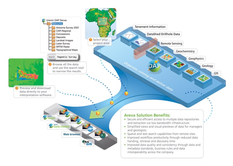
The anchor for Areva’s Exploration Information Management solution is Seequent’s DAP server technology, which has allowed Areva’s geoscientists access to data on demand from a single interface instead of having to tap into separate repositories for information.
Integration with their Datamine MineTrust, Maxwell Datashed and LeaseControl systems expanded the breadth of data available to explorationists throughout the organization.
“Our DAP server is enabling us to build a library of maps and information for each project that we can share not only with geologists within our group, but with all exploration groups within our company,” says Masset.
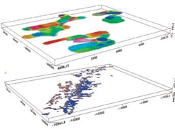
Areva South Africa has also standardized on common tools for their exploration projects: Seequent’s Oasis Montaj for advanced mapping and data processing of geophysics, geology and geochemistry; Target and Target for ArcGIS to create sections and 3-D models for subsurface (drillhole) data within their ArcGIS environment.
The tight integration between Seequent exploration software and ESRI’s ArcGIS has been critical, and it’s meant that Areva geologists are able to access, explore and work with their data directly within their ArcGIS or Seequent environment, depending on the project they are working on. Exchange of maps and data between the two environments is also fast and efficient with ArcGIS built into the Seequent mapping platform.
Together, these tools have provided Areva Resources’ multi-disciplinary exploration team in South Africa with a suite of spatial analysis tools that improve workflow by increasing efficiency, making decision-making easier and supporting better communication between project team members and management.
The improved productivity that comes from managing and sharing exploration information efficiently is seen as a key business benefit.
“Our Seequent and GIS software helped us to map everything out and manage our projects more effectively,” says Olivier Masset, manager of resources and GIS for Areva Resources Southern Africa. “We can combine and consider not only the geology, but all the relevant project information. That accelerates our decision-making on – for instance – where to focus our exploration or whether to start drilling or resample.”
He says that before Areva Resources introduced the Seequent software to its field offices, data would be sent to head office in Johannesburg, where it would be made into sections and field maps before being sent back to the field. Using common exploration tools, the geoscientists can now complete these tasks in the field, saving time at head office and allowing project managers to make immediate decisions about where to explore next.
Masset is particularly enthusiastic about the ability to integrate data from the field into the exploration model, continuously providing his team with added information and fresh perspectives on the mineral potential of a particular project.
Data mobility is also an important advantage. With their solution, managers and geologists can move from region to region and still have easy access to data housed in the DAP server in Johannesburg.
“Access to information and the ability to share information in real time is important to us” says Masset. “The ability to do this on a global basis, where someone from southern Africa can go to Canada and find the same data, is a competitive advantage that enables us to be more flexible and quicker in developing our projects.”
Compatibility with other programs, not only within the Seequent suite but from other software providers (e.g. AutoCAD), is another feature that makes the job easier for Mani. “As a person managing the company’s GIS database which stores critical information about 3D maps, borehole plans and sections for analysis, I would say Seequent has enormous capabilities, including bringing in data from different formats used in the mining and exploration industry.”
“We’re encouraged with our progress,” says Mani. “As more geologists and managers are trained on the new tools, they are gaining confidence in the quality of the data and their ability to extract information from their data. There’s no doubt this will impact our ability to develop our projects and make meaningful decisions.”
As a result, Areva has made its new Southern African subsidiary a test pilot for establishing a common platform for exploration including protocols, best practices and software tools that are standard across the organization.
If proven successful, the common exploration platform Areva Southern Africa is striving to create could become a model not only for its parent company, but for the mining sector as well.