The GCM (Ground Conductivity Meter) extension is a comprehensive solution for importing, processing and inverting GCM data. It supports a wide range of coil configurations for import and inversion, with a straightforward process for adding system information during data import. Integrated with the GIS interface, the extension provides a complete workflow from raw data to final results, including quality control and inversion result inspection. Modelling and presentation to the customer are done with the well-known functions of the Workbench, making it easy to integrate with boreholes, create reports, and more.
Key features
- Flexible and easy-to-use importer, supporting diverse GCM system setups
- Advanced processing tools with automatic data filtering
- GIS interface integration
- Automated LCI/SCI data inversion
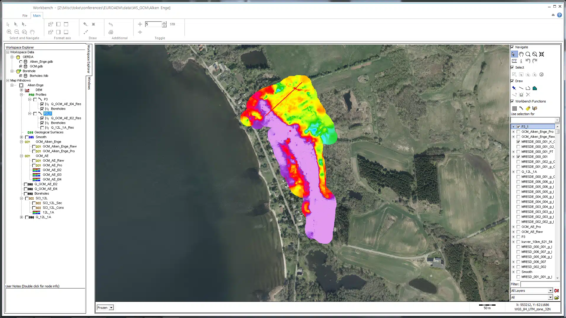
- Visualisation of data and inverted models on the GIS and cross-sections
- Integrated QC tool
Data in xyz format can be imported with the following information:
-
Data in apparent resistivity (ohm), conductivity (mS/m) or ppm
-
UTM coordinates
-
Coil configuration
-
Coil distances and coil altitudes
-
Instrument frequencies
For each coil configuration, relative and absolute standard deviation can be added. Column mapping is done with a mapping editor and both data mapping and system information can be saved/loaded in the importer.
The importer also supports a so-called sps format, simplifying data import and processing. If you are writing your data acquisition software or use the software developed by Aarhus University, please enquire about the format.

Processing & inversion
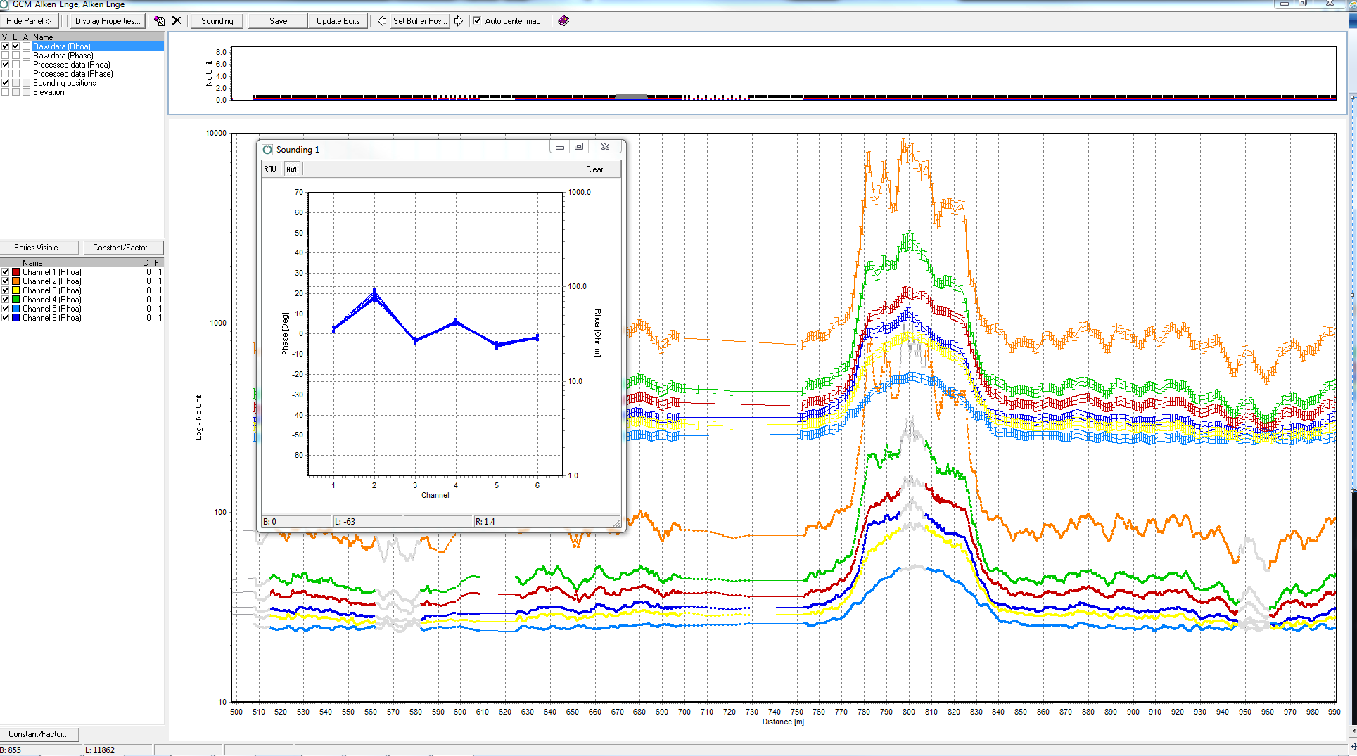
The extension includes two noise suppression algorithms, with options for automatic or custom settings. A GPS shift can be applied to ensure the data points are aligned with the horizontal focus point of the given transmitter–receiver coil configuration. The processing window allows for raw and processed data comparison for each channel, data point removal, and editing and plotting of individual soundings. Its direct link to the GIS interface facilitates easier data point location and processing.
Utilising the AarhusInv inversion code, GCM data can be inverted with layered, smooth, or sharp model setups, as LCI or SCI, along with a Depth Of Investigation (DOI) calculation.
Inversion results and quality check
Easily inspect the quality of the inversion models to identify areas that can be trusted and where further processing is needed. Very importantly, a depth of investigation is calculated for each sounding, precisely indicating how deep the models are trustworthy.
Different themes can be created for showing the inversion results, e.g. resistivity themes or a layer search can be created to visualize depth to a layer with certain conditions. Profiles can be drawn on the GIS interface, with the ability to add boreholes, 3D grids, and other geophysical data for comprehensive data comparison and geological surface mapping.
Applications
GCM data collection is cost-effective and covers large areas swiftly, providing detailed near-surface insights. It is applicable in diverse areas including soil mapping, dump site identification, raw material exploration, landslide-prone area assessment, permafrost study, geotechnical engineering, and archaeological structure detection.