


The 9.8 release of Oasis montaj, Target, and Target for ArcMap introduces support for 2.5D TDEM inversions,
allowing you to gain new 3D insights and interpretations from TDEM data. You can also experience significant performance improvements when viewing 3D data; usability improvements to enhance and modernise the user experience; and the first phase of even more seamless Seequent workflows. Target for ArcGIS Pro 2.1 introduces new workflows that allow you to increase drillhole planning efficiency.
VOXI 2.5D Time Domain EM is under development and not available for purchase.
For more information and to download visit MySeequent.
Duration
6 min
See more on demand videos
VideosFind out more about Seequent's mining solution
Learn moreVideo Transcript
[00:00:01.110]
<v Instructor>Hi, my name is Jeff</v>
[00:00:02.870]
and in this video,
[00:00:03.890]
I will discuss some of the new features
[00:00:05.790]
in the May 2020 Geosoft product release.
[00:00:09.200]
This update continues to strengthen the geophysical
[00:00:11.870]
and geoscience portfolio,
[00:00:13.410]
through new industry leading features.
[00:00:16.030]
The 9.8 release
[00:00:17.430]
of Oasis montaj, Target and Target for ArcMap
[00:00:20.890]
includes significant performance improvements
[00:00:23.160]
when viewing 3D data.
[00:00:25.180]
We also introduce support
[00:00:26.750]
for 2.5D time domain EM inversions,
[00:00:30.160]
allowing you to gain 3D insights and interpretations
[00:00:33.060]
from time domain EM data.
[00:00:35.400]
We’ve also included improvements
[00:00:37.250]
to enhance and modernize your experience,
[00:00:40.010]
plus a sneak preview of integration with Seequent Central,
[00:00:42.960]
to provide seamless workflows with Leapfrog.
[00:00:45.750]
Now let’s take a closer look at what’s new in this release.
[00:00:49.270]
One of the first enhancements
[00:00:50.610]
you will notice with the update
[00:00:52.000]
is that we’ve improved and modernized
[00:00:53.820]
the user interface of Oasis montaj and Target.
[00:00:57.000]
This includes a main menu cleanup
[00:00:58.960]
with the removal of the edit and settings menu,
[00:01:01.580]
with the functionality move to more appropriate locations.
[00:01:04.980]
We have also updated the application style
[00:01:07.670]
and window colors to be more contemporary.
[00:01:10.350]
This also includes enhancements to the usability
[00:01:12.680]
of the Geosoft database window.
[00:01:15.490]
The menus have also been reorganized
[00:01:17.410]
in a more logical manner,
[00:01:19.050]
working from importing and visualizing your data,
[00:01:21.750]
to modeling your data
[00:01:22.960]
as you move from left to right across the menu bar.
[00:01:26.350]
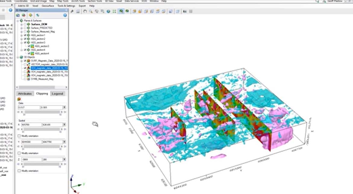
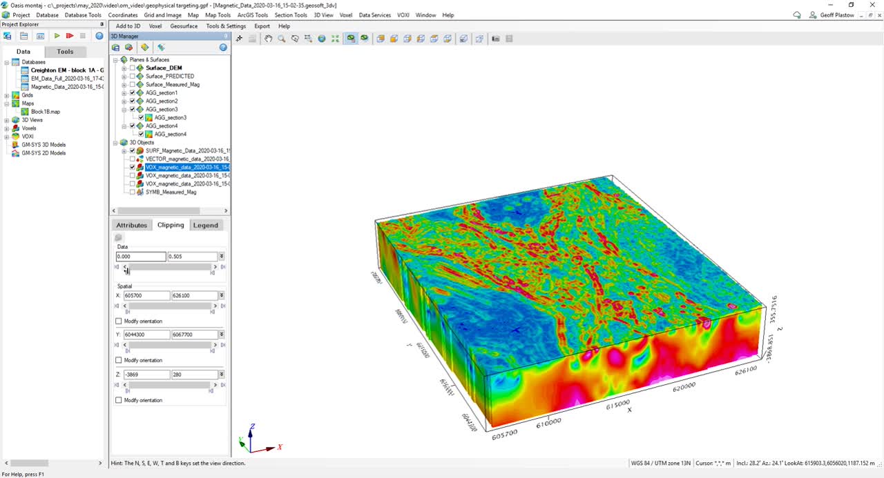
Now I would like to mention 3D views.
[00:01:29.060]
Our team has made significant performance improvements
[00:01:31.890]
to 3D views inside of Oasis montaj and Target.
[00:01:35.440]
We now have near instantaneous mouse response,
[00:01:38.040]
regardless of the number of objects that are in the 3D view.
[00:01:41.620]
This means you can add many voxels, grids, sections,
[00:01:44.510]
ISO surfaces and drillholes
[00:01:46.240]
and not worry about performance issues.
[00:01:48.710]
Depending on your computer setup,
[00:01:50.100]
you should see speed improvements of 10 to 17 times faster.
[00:01:54.150]
Oasis montaj, Target,
[00:01:56.040]
the Geosoft Viewer, VOXI and GM-SYS 3D
[00:01:59.080]
all benefit from this improvement.
[00:02:02.140]
And now for Seequent Central.
[00:02:04.120]
In this release,
[00:02:04.953]
we are providing a sneak peek of the integration
[00:02:06.920]
of Oasis montaj and Target with Central.
[00:02:09.860]
This is an important step,
[00:02:11.250]
in connecting the Geosoft product suite,
[00:02:13.230]
to the larger Seequent ecosystem.
[00:02:16.500]
With this new functionality,
[00:02:17.640]
you can now export grids and voxels to Seequent Central.
[00:02:21.450]
By right clicking and uploading your grid or voxel
[00:02:24.150]
to the central server of your choice.
[00:02:26.990]
Alternatively, you can use the updated data services menu
[00:02:30.220]
to upload multiple sets of grids or voxels
[00:02:33.020]
to the central server.
[00:02:35.510]
Central is a model management solution,
[00:02:37.240]
which helps you visualize track and integrate and manage
[00:02:40.570]
your geoscience data
[00:02:41.750]
from a centralized audible environment.
[00:02:44.530]
Now with a couple of clicks,
[00:02:45.770]
your data can be securely uploaded and saved to the Cloud.
[00:02:49.570]
For those working in Leapfrog,
[00:02:51.470]
you can simply download and open these grids
[00:02:54.110]
directly from Central into your project.
[00:02:58.280]
We’re also excited,
[00:02:59.540]
to announce the release
[00:03:00.373]
of VOXI 2.5D time domain modeling.
[00:03:04.180]
The benefit of the 2.5D algorithm
[00:03:06.600]
includes better recovery of dipping structures
[00:03:08.880]
and compact bodies,
[00:03:10.570]
providing a more robust conductivity model.
[00:03:13.550]
This is a model that’s free
[00:03:14.780]
from one dimensional inversion artifacts.
[00:03:17.850]
Currently the algorithm is accessible
[00:03:19.680]
through an early adopter program.
[00:03:21.640]
So please contact us to learn how to participate
[00:03:24.220]
and stay tuned for the full release.
[00:03:26.710]
We’re also pleased to announce
[00:03:28.080]
our VOXI self-service trial.
[00:03:30.810]
We have automated the trial process
[00:03:32.610]
so if you’re interested
[00:03:33.460]
to test out VOXI Earth Modeling for yourself,
[00:03:36.100]
please check this out.
[00:03:37.740]
This is available through the VOXI store,
[00:03:39.650]
starting on May 29th.
[00:03:42.790]
For GM-SYS, our team has also added
[00:03:45.020]
some great new functionality to GM-SYS profile.
[00:03:48.210]
You can now easily display a geo-referenced grid or image
[00:03:51.570]
through a new workflow,
[00:03:52.820]
allowing the integration of raster data and GM-SYS profile.
[00:03:56.810]
This means you can display gridded data
[00:03:58.840]
in plan or section,
[00:04:00.660]
and display interpretations
[00:04:02.230]
from Leapfrog, Seismic or empty data
[00:04:04.630]
geo-referenced right in your GM-SYS project.
[00:04:08.630]
Now with GM-SYS profile,
[00:04:10.150]
we support a new model document.
[00:04:12.340]
The new model documents supports easy backups
[00:04:14.930]
and sharing of your models.
[00:04:16.830]
You also reduce the risk of losing your data.
[00:04:19.980]
Now instead of having to manually search
[00:04:22.100]
and archive all of your project files,
[00:04:24.250]
you can simply save the model
[00:04:25.840]
and all of the relevant files
[00:04:27.390]
will be archived into a single file.
[00:04:30.890]
And now for UX-Analyze.
[00:04:33.050]
With this release,
[00:04:34.048]
UX-Analyze now it makes full use
[00:04:36.050]
of the HDF version zero file format.
[00:04:39.370]
This is a great enhancement
[00:04:40.580]
for users working with EM sensor data,
[00:04:42.950]
including the metadata
[00:04:44.040]
describing the sensor’s configuration.
[00:04:46.750]
This is a huge time saver
[00:04:48.190]
and reduces the need for configuration files
[00:04:50.770]
when you’re in the field.
[00:04:52.530]
Any changes to the sensor’s parameters
[00:04:54.460]
will be used by UX-Analyze
[00:04:56.330]
in subsequent data processing.
[00:05:00.110]
UX-Analyze now supports data captured,
[00:05:02.650]
as part of a dynamic survey using the MPV sensor.
[00:05:06.660]
The Man-Portable Vector,
[00:05:08.500]
is one of the most popular sensors
[00:05:10.280]
for advanced geophysical classification
[00:05:12.880]
and is now supported by UX-Analyze inside of Oasis montaj.
[00:05:17.950]
And now for Target for RJS Pro, version 2.1,
[00:05:22.270]
With the release of Target for RJS Pro 2.1,
[00:05:25.120]
we are pleased to introduce
[00:05:26.390]
a new drillhole planning workflow.
[00:05:29.100]
This new feature allows you to plan new drillholes
[00:05:31.550]
in ArcGIS Pro.
[00:05:33.500]
Now you can communicate drilling priorities to your team
[00:05:36.050]
and advanced exploration projects to discovery.
[00:05:39.910]
We now also have the ability to get elevation values
[00:05:42.410]
from topographic rasters.
[00:05:44.240]
Now if your drillhole collars
[00:05:45.620]
do not match your typography,
[00:05:47.230]
you can simply replace
[00:05:48.830]
or correct collar information.
[00:05:51.120]
You may also examine errors
[00:05:52.580]
and interrogate elevation values
[00:05:54.110]
at other collar locations.
[00:05:56.810]
If you would like to find out more about these features
[00:05:59.390]
and download the latest version of the software,
[00:06:01.840]
check out the release page on my.seequent.com.