


On November 28, 1945, a subduction zone earthquake measuring 8.1 on the Richter scale occurred off the Makran Coast of what is now Pakistan. The resulting tsunami struck not only Pakistan but Iran, India and Oman with wave heights ranging from 2 to 13 metres. More than 4,000 people were killed, making it the second-deadliest tsunami ever to have occurred in the Indian Ocean – exceeded only by the Indonesian event of December 26, 2004, which killed upwards of 280,000.
Pilarczyk, at right, with McMaster University former graduate student Simon Donato searching for evidence of older tsunamis that have impacted the Omani coastline. Ras al’Had Sabkah, Oman, Arabian Peninsula, February 2007.
Understanding such past disasters can go a long way toward predicting comparable ones in the future. Problem is, researchers lack sufficient eyewitness accounts and the body of geological evidence is small.
Fortunately attempts to analyze overwash deposits (the flow of water and sediment that does not return directly to its source) are proving helpful. This approach, which considers how storms, tsunamis and sea-level change have altered coastal systems, is the brainchild of Jessica Pilarczyk, who is currently doing post-doctoral research at the University of Pennsylvania’s Sea Level Research Lab.
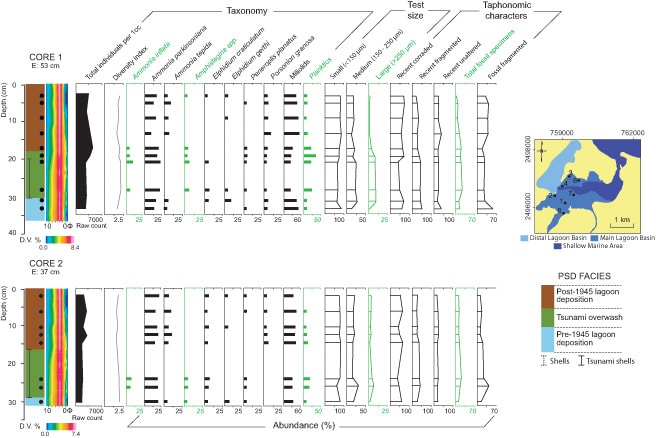
Pilarczyk began by developing a method for detecting paleo-tsunamis using foraminifera (mircro-organisms) and mollusks and their taphonomic, or decay-related, characteristics. The latter include angularity, colour, size, fragmentation, and so on. It wasn’t long before the method proved successful in Sur Lagoon, Oman, which contains stratigraphic evidence of the 1945 Makran tsunami. Similar studies of overwash at Anegada in the British Virgin Islands are shedding light on tsunami threats in the eastern Caribbean islands.
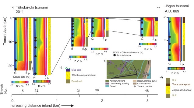
A recent test involved sampling inland deposits from the 2011 Japanese tsunami and comparing them with underlying sediments deposited by an older event in the same area, namely the Jogan tsunami of AD 869. The methodology consisted of removing organics from the sediment samples, homogenizing them, and identifying foraminifera taxonomy and condition. Grain-size analyses were done using a laser-diffraction particle size analyzer. Then, grain-size values for all samples were converted to the Wentworth-Phi Scale, interpolated, gridded, and plotted as particle size distributions (PSDs) in Geosoft Oasis montaj.
“Using Oasis montaj provided the best way to effectively display detailed high-resolution particle size data,” says Pilarczyk. The software makes it possible to collapse hundreds of individual sediment profile graphs into one easy-to-interpret PSD plot, which in turn allows for the evaluation of subtle but important trends in the sediment record. “PSDs created in Geosoft Oasis montaj have enabled my research group to delineate previously undocumented tsunami deposits from Oman, the Caribbean, Japan, Sumatra, Chile, French Polynesia, and Alaska,” Pilarczyk notes.
In the Japanese test, researchers were able to discriminate between the tsunami deposit and the underlying soil because of the presence of recent and fossil foraminifera. There was also a pronounced change in grain size, which became finer upward and landward. Moreover, the PSDs showed the distinct separation of sand units deposited by both the 2011 and AD 869 tsunamis from the finer soils.
Pilarczyk and her research group are now assessing the risk of tsunamis to the Tokyo region by locating and interpreting geologic evidence of older events preserved along the coastline. “Anticipated outcomes of this are significant and include the first-ever geologic documentation of tsunamis impacting Tokyo,” she notes.
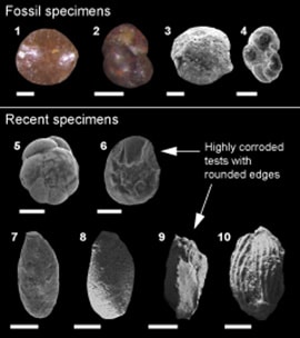
Scanning Electron Microscope (SEM) images of foraminifera indicating varying test (shell) condition. Fossil and unaltered (e.g., no evidence of corrosion and abrasion) foraminifera are indicators of tsunami overwash.
Meanwhile in Indonesia, she is using the technique to map out modern foraminiferal distributions off northern Sumatra so that they can be compared to a series of overwash deposits found in a coastal cave. Similar research is under way in Chile and the South Pacific islands of Wallis and Futuna.
The technique is also of interest to climatologists. “Climate projection models are increasingly using geologic evidence of sea-level change and storm frequency to constrain their models and provide more accurate projections,” says Pilarczyk.