


Ronald S. Bell, Senior Geophysicist at International Geophysical Services LLC discusses:
- His experience with UAVs in the mineral exploration industry
- The benefits of UAV surveys
- The limitations and restrictions of conducting drone surveys
- UAV sensors for mapping geology
- The MagArrow and what the device does
- The Crestone Crater case study
This presentation was recorded at PDAC 2020.
Overview
Speakers
Ronald S. Bell
Senior Geophysicist – International Geophysical Services LLC
Duration
32 min
See more on demand videos
VideosFind out more about Seequent's mining solution
Learn moreVideo Transcript
[00:00:00.000](light music)
[00:00:11.130]<v ->Thank you for coming to my presentation.</v>
[00:00:15.180]Some of you I’ve met yesterday when
[00:00:17.020]I was out walking the booths and invited you here.
[00:00:20.480]I’m happy you showed up for this.
[00:00:23.010]The title of my presentation is
[00:00:24.880]UAV MagArrow surveys for improved,
[00:00:29.580]I think it’s to improve geologic mapping.
[00:00:32.960]Just before I begin, this is a MagArrow
[00:00:36.140]and Geometrics, Naiema over here is a representative
[00:00:40.098]for Geometrics, and she can tell you a lot
[00:00:42.630]about the product, that magnetometer.
[00:00:46.840]I want to start that
[00:00:48.750]so that I don’t forget to bring her into the conversation.
[00:00:52.650]Today’s talking points.
[00:00:54.310]I’m going to talk about my experience with UAVs.
[00:00:58.600]What’s relevant to, at least somewhat to,
[00:01:01.580]the mineral exploration game.
[00:01:03.760]The benefits of the UAV surveys.
[00:01:07.048]I’m going to talk about the limitations and restrictions
[00:01:10.900]of doing drone magnetics,
[00:01:13.390]actually just drone surveys in general.
[00:01:15.830]I’m going to speak a little bit about UAV sensors
[00:01:19.310]and for mapping geology and then I’m going to get into
[00:01:22.570]talking a little bit about the MagArrow.
[00:01:24.180]Explain what this device particularly does
[00:01:26.550]and then I’m going to go through a case history
[00:01:28.280]of a project that I’ve,
[00:01:29.850]I’ve actually been working on for about three years now.
[00:01:33.430]I’ve flown a lot of MagArrow surveys on this one,
[00:01:37.380]and then I’m going to conclude my remarks
[00:01:39.660]with some things that I think are important to be aware of.
[00:01:43.570]Before I begin though,
[00:01:44.630]how many in the audience have actually done
[00:01:48.210]drone surveys for mapping geology?
[00:01:51.830]You can raise your hands.
[00:01:53.420]One, two, okay, three.
[00:01:56.180]You guys probably have too.
[00:01:57.420]So how many have done drone magnetic surveys?
[00:02:02.440]Okay, well, hopefully this won’t be real basic for you guys.
[00:02:08.260]Hopefully I’ll give you some information.
[00:02:10.540]For the rest of you, I hope that I’m actually
[00:02:14.950]sharing what I’ve learned in the last
[00:02:17.230]three or four years, doing drone magnetics.
[00:02:22.970]This is my relevant experience.
[00:02:25.916]I claim to be a senior geophysicist and I only claim that
[00:02:30.530]because I’m a senior at this point in my life.
[00:02:33.690]I am a geodroneologist, it’s a word that I made up.
[00:02:40.610]I use drones to map geology. That’s why I made it up.
[00:02:48.900]I’ve done over 30 commercial surveys since I began
[00:02:54.156]in the fall of 2018,
[00:02:56.000]I began actually operating as a commercial service provider.
[00:03:00.250]And I can’t really read my thing here.
[00:03:04.570]I’m collaborating with Seequent and Geosoft
[00:03:07.670]to actually build some tool sets
[00:03:09.530]or they’ll build the tool sets within Geosoft
[00:03:12.400]that’ll make the processing of drone magnetic data
[00:03:17.180]or other data types that are acquired with drones,
[00:03:20.960]at least geophysical data types,
[00:03:22.800]a much more efficient process.
[00:03:25.070]So thank you.
[00:03:27.980]And then at the bottom, in the fine print,
[00:03:29.960]is that fact that I’d been in this business
[00:03:31.960]for more than four decades.
[00:03:34.290]So the benefits of UAV surveys,
[00:03:38.880]the first one foremost is you get a bird’s eye view.
[00:03:41.920]So we can actually acquire multiple data types.
[00:03:45.902]With the drone, sometimes it’s in the same missions.
[00:03:50.770]Sometimes it’s in different missions.
[00:03:53.530]We can access difficult areas with a drone
[00:03:56.560]that you can’t really do very well on the ground.
[00:04:00.250]And in some cases, a conventional pilot airborne survey
[00:04:05.290]is challenging to do with that as well.
[00:04:09.500]We can increase the spatial data density.
[00:04:12.290]I believe that to be one of the strongest reasons
[00:04:15.190]or most important reasons to actually use drone magnetics
[00:04:19.090]or drones in general.
[00:04:21.570]We improve our signal strength
[00:04:23.170]by being closer to the ground.
[00:04:25.670]We can have relatively speaking, a low cost operation.
[00:04:30.310]We enhance the safety of the field staff.
[00:04:34.221]Where they’re not as much at risk because they’re using
[00:04:39.120]essentially an airborne robot to acquire the data.
[00:04:43.780]We reduce the risk to property damage.
[00:04:46.870]These are not big vehicles, they’re not big aircraft.
[00:04:49.180]They don’t really cause a large impact when they crash.
[00:04:53.800]We facilitate temporal change detection.
[00:04:56.980]What that means is that we can fly a survey
[00:04:59.670]and then we can come back at another point in time
[00:05:01.770]and fly it again, and look at the differences
[00:05:03.560]between those two datasets.
[00:05:05.710]I’m speaking in a general sense,
[00:05:07.300]but it’s actually a very useful methodology
[00:05:12.350]for better understanding what’s in terms of geology
[00:05:15.030]or understanding of geological process.
[00:05:19.660]And one of the things that I actually added onto this
[00:05:26.040]for this thing is I do near real time magnetic maps
[00:05:30.550]in the field.
[00:05:31.850]I actually produce a map in the field
[00:05:34.500]almost within moments of actually acquiring the data
[00:05:38.500]with the MagArrow.
[00:05:39.935]So that’s due in large part to
[00:05:43.720]the use of the Geosoft software.
[00:05:46.360]It’s in the field, on my computer,
[00:05:48.250]and I’m actually processing while the guys are flying.
[00:05:54.890]So the limitations.
[00:05:57.810]If you haven’t done a drone survey at all,
[00:06:01.460]I’ll tell you the first limitation is the weather
[00:06:04.550]and wind is not our friend,
[00:06:06.800]but we can actually get around that.
[00:06:10.350]We can wait out the weather and actually fly
[00:06:12.520]when we do have moments of good flying weather.
[00:06:16.710]Site access is a challenge.
[00:06:19.380]Vertical structures like trees, they can be a challenge.
[00:06:23.190]Short duration flights, the drone I use,
[00:06:26.200]I get about 15 to 20 minutes of flight time.
[00:06:29.640]I’m looking at drones that now have hours of flight time.
[00:06:35.320]Small payloads, the drone I use carries
[00:06:38.700]about five kilograms.
[00:06:40.380]I’m looking at drones that actually will carry
[00:06:42.260]up to 20 kilograms.
[00:06:43.390]So I’m looking in the future
[00:06:45.210]that we’re going to be putting more sensors on it,
[00:06:47.430]or different types of sensors that actually way more
[00:06:50.840]than this particular sensor, the MagArrow,
[00:06:53.960]which actually weighs a kilogram.
[00:06:55.410]So we’re not really stressing the drone,
[00:06:58.500]the drone I’m using, with this payload.
[00:07:03.590]And then the aircraft flight characteristics
[00:07:06.030]are our limitation.
[00:07:09.020]The restrictions, and I’m speaking from the U.S. experience,
[00:07:12.780]I know Canada has their own regulations,
[00:07:15.530]very similar to the U.S.
[00:07:16.950]and other countries in the world are
[00:07:18.280]starting to develop a whole series of regulations
[00:07:20.699]to manage drone traffic.
[00:07:23.180]I won’t go through all of that, but the big one
[00:07:25.110]that becomes an issue is that I have to maintain
[00:07:29.890]at this point in time, visual line of sight with the drone,
[00:07:35.410]actually it’s the pilot maintains it so.
[00:07:41.300]So, I put this together several years ago
[00:07:44.030]and what I did it for was, yeah.
[00:07:49.450]To try to explain all the things, all the sensors,
[00:07:51.890]things that we could do with a drone
[00:07:53.860]to help map geology and do other things with it,
[00:07:56.280]from photogrammetry, which is visible light
[00:07:59.230]to infrared, there’s a number of infrared sensors on there,
[00:08:04.870]LIDAR, you probably all know what LIDAR is
[00:08:08.470]and then the geophysics components, which include gamma ray,
[00:08:11.340]magnetics, electromagnetics, and ground-penetrating radar.
[00:08:14.950]I really wanted to get that out there
[00:08:16.630]that we can do a lot more with drones then,
[00:08:20.950]and even it’s even better today, than when I first started.
[00:08:23.710]So.
[00:08:27.850]The MagArrow is that picture on the right there,
[00:08:32.530]on my right, your left.
[00:08:34.630]That’s the picture of my aircraft.
[00:08:37.330]It’s a DJI Matrice 600 Pro
[00:08:40.320]and I suspend the MagArrow,
[00:08:42.330]which is the device that’s hanging below it,
[00:08:48.970]about three to four meters.
[00:08:50.770]What I’m doing is moving it away from the aircraft
[00:08:55.490]so I know I don’t have any electromagnetic interference
[00:08:58.921]in my measurements.
[00:09:04.720]Inside this are two sensors that are cesium vapor sensors.
[00:09:09.172]They’re oriented orthogonally.
[00:09:11.970]That means that this thing has no dead zone.
[00:09:17.300]That’s where the sensors are up here, or is a IMU,
[00:09:22.220]GPS, accelerometers, a gyroscope.
[00:09:25.650]It’s actually measuring the roll, pitch, and yaw
[00:09:27.900]of this aircraft, as well as the position.
[00:09:30.450]I mean, it’s not aircraft, I mean it’s a sensor,
[00:09:33.850]as well as the position of the sensor during the survey.
[00:09:36.780]And that’s the data that I use to position the data
[00:09:40.243]when I map it up, also involved in this front piece
[00:09:44.740]is a wifi, and that’s how we actually communicate with it.
[00:09:48.407]Either with our cell phone or a tablet or computer,
[00:09:51.970]I find so far that it works best for me
[00:09:54.730]to use a Windows 10 computer.
[00:09:59.530]So that’s basically,
[00:10:01.070]everything’s integrated into one package.
[00:10:03.720]It’s not dependent on the aircraft.
[00:10:06.150]So you could actually use this in other environments,
[00:10:10.750]not with a drone,
[00:10:11.670]but you could use it on the ground,
[00:10:13.130]you could use it in a boat.
[00:10:19.100]That’s that.
[00:10:20.990]It’s made by a company in California called Geometrics.
[00:10:25.110]They’ve got some literature up here, if you wish to have it.
[00:10:28.640]So the kinds of projects that I’ve done so far,
[00:10:31.890]I’ve done a bunch of mineral exploration projects.
[00:10:34.160]I’ve worked at high altitude,
[00:10:36.690]or at least where the state’s high altitude
[00:10:38.440]is 12,400 feet above sea level.
[00:10:42.600]I’ve worked in very rugged terrain,
[00:10:45.170]I’ve worked in very tree covered terrain,
[00:10:47.420]very similar to the kind of forest
[00:10:50.450]you have in Eastern Canada.
[00:10:53.090]It was in the U.S. but it was in,
[00:10:56.329]in fact it was in the upper peninsula of Michigan.
[00:11:00.280]I’ve worked in the deserts of the Southwest
[00:11:02.890]in the middle of August, which it’s hot.
[00:11:08.290]So I’ve worked on mine sites, doing mine site
[00:11:12.110]characterization in an active mine.
[00:11:14.720]I’ve done groundwater resource assessments.
[00:11:17.850]I’ve done oil and gas exploration
[00:11:19.690]with some projects with this,
[00:11:22.370]I’ve located a whole bunch of oil and gas wells
[00:11:24.840]using this device.
[00:11:27.450]And I’ve characterized a landfill.
[00:11:30.320]And what I’m going to talk about is
[00:11:32.380]I’ve investigated what is thought to be an impact crater.
[00:11:37.520]It’s a topographic feature,
[00:11:40.890]and I’m going to get right into talking about that.
[00:11:44.200]The crater, we name somewhat affectionately,
[00:11:47.310]Crestone Crater.
[00:11:48.250]It’s just south of the town of Crestone, Colorado,
[00:11:54.242]on the edge of the San Luis Valley.
[00:11:57.797]There we go. Can you see that?
[00:12:01.373]I don’t know how to turn that on.
[00:12:04.310]It’s inside the Great Sand Dunes National Park.
[00:12:08.150]We got special permission to actually fly inside the park.
[00:12:13.740]That’s not something that you normally can get.
[00:12:16.440]The picture on the right, on my right at least,
[00:12:21.430]that’s the actual crater.
[00:12:22.730]It’s about a hundred meters across
[00:12:24.820]and in the sixties, there were some geologists
[00:12:27.373]that came out and looked at it
[00:12:28.640]and they were hypothesized as it being a impact crater.
[00:12:34.130]So it has that kind of feature.
[00:12:36.070]So in the background on that picture,
[00:12:39.660]this, actually this photo was taken from a drone.
[00:12:42.550]The background is the Great Sand Dunes,
[00:12:46.560]in the Great Sand Dunes National Park.
[00:12:48.870]And you can see we’re on a range front,
[00:12:52.750]near a mountain range.
[00:12:55.140]So it was hypothesized to be an impact crater in 1965,
[00:13:00.450]by the Smithsonian geologists.
[00:13:02.820]USGS geologists came out and said they found no evidence
[00:13:06.100]of it being an impact crater,
[00:13:07.920]but the surface sands contain about 4% magnetite.
[00:13:11.950]That was what they reported.
[00:13:14.250]In 2011, the Colorado School of Mines geophysics students
[00:13:18.970]used it as a site for their senior design project
[00:13:22.990]and they did some ground magnetics on it.
[00:13:28.860]It had a magnetic signature
[00:13:30.590]and when I was looking for a place early on in my work
[00:13:33.870]with the prototypes of the MagArrow,
[00:13:36.990]I actually was approached by a group
[00:13:39.530]to be able to fly inside the park service.
[00:13:42.190]And, I mean, inside this national park, and I said, yes,
[00:13:46.470]I’ll come down and we’ll figure out where I can fly.
[00:13:48.660]And this actually popped up.
[00:13:49.880]’cause I knew I could get a response from it.
[00:13:52.350]So in 2017, I did my first drone mag survey.
[00:13:57.090]There was a magnetic high associated directly with that rim
[00:14:01.250]or that berm of that topographic feature.
[00:14:04.520]In 2018, I went back and performed a bigger survey.
[00:14:08.870]Both of those years,
[00:14:09.950]I was using a prototype version of the MagArrow.
[00:14:12.920]In the fall of 2018,
[00:14:14.960]Geometrics released and introduced the MagArrow
[00:14:18.500]at a conference, the SEG conference in the fall.
[00:14:23.250]And since then I’ve performed more than
[00:14:27.261]30 commercial surveys using the commercial version.
[00:14:31.010]And, in 2019, I went back again and I flew that
[00:14:36.010]because I find this a little humorous is that,
[00:14:40.510]every time I got a dataset, I concluded I needed more data.
[00:14:44.830]So you’ll see this in my process here.
[00:14:50.330]So this is the first survey.
[00:14:53.420]And what you see here is I’ve trimmed up the flight lines.
[00:14:56.840]I do all the processing in Geosoft,
[00:14:58.650]so one of the things you do is you,
[00:15:00.570]it runs a continuous, this thing turns on,
[00:15:02.970]you lift it off, it goes off and starts recording.
[00:15:05.930]And when it comes back to the,
[00:15:07.770]it’s recording it on an SD card inside the device,
[00:15:11.000]when it comes back,
[00:15:12.020]we’re actually downloading it over a wifi connection
[00:15:15.190]to our PCs of some type.
[00:15:17.900]And so then we begin the processing of trimming it up
[00:15:22.160]and then making individual flight lines and timelines.
[00:15:25.800]And the background here, this red line,
[00:15:30.468]after the crew got finished,
[00:15:32.150]I hired a crew to come down to fly it.
[00:15:34.602]I went out and collected a ground data set on it.
[00:15:39.050]And I think one of the things is evident
[00:15:40.690]is I don’t walk a straight line.
[00:15:45.360]The drone does a much better job of keeping on target there.
[00:15:51.590]So what we did here is,
[00:15:53.210]it was about a 500 and 500 meter flight block,
[00:15:56.760]20 meter line spacing, 100 meter tie line spacing,
[00:16:00.580]sensor altitude was about 16 meters above the ground level.
[00:16:05.210]I did it in four sorties.
[00:16:07.360]We did it from one location right here.
[00:16:09.660]That’s actually the shot of the pilot
[00:16:11.940]and the drone, the prototype version.
[00:16:15.020]This gentlemen here is a geologist
[00:16:16.440]for the National Park Service.
[00:16:17.740]He was very curious of what we were going to do.
[00:16:20.070]And at the time that we completed that survey
[00:16:22.330]was less than four hours.
[00:16:23.970]The guy showed up at eight o’clock in the morning.
[00:16:26.180]They flew it, finished it up,
[00:16:27.627]and they were out of there by noon.
[00:16:29.890]I then went out and spent the next four hours
[00:16:31.910]collecting this ground data so.
[00:16:35.950]But what’s it look like?
[00:16:37.750]Well, the bigger survey is the drone mag data.
[00:16:42.650]And this is really as raw data as I got,
[00:16:48.130]I haven’t done a lot to actually improve the data.
[00:16:53.380]The interior survey, interior color contours,
[00:16:57.340]are from my ground mag survey.
[00:16:59.570]What I was doing here, I was just trying
[00:17:01.500]to see a comparative study between,
[00:17:04.100]trying to compare what I was able to get
[00:17:05.820]with the prototype of the MagArrow
[00:17:08.230]and what I could get on the ground
[00:17:09.680]with a cesium vapor magnetometer, a ground-based one,
[00:17:13.430]that’s used often for mineral exploration, and I was able,
[00:17:16.850]you can see that I have this circular feature here.
[00:17:19.570]I also have something going on here,
[00:17:22.310]and I have a few more circular features.
[00:17:24.730]There’s something here that’s actually distorting
[00:17:26.817]the field a bit.
[00:17:29.470]Well, the conclusion at the end of that survey was
[00:17:33.560]I needed more data.
[00:17:36.120]So, but this is the vertical derivative
[00:17:39.970]of the drone mag’s survey.
[00:17:42.700]These features right here became very interesting to me
[00:17:45.210]because we just started studying this one,
[00:17:48.510]but we’re starting to see these other circular features,
[00:17:51.840]which kind of raised a few questions.
[00:17:56.390]So in 2018, I went back with a second generation prototype
[00:18:01.290]and we flew a square mile.
[00:18:02.750]This is 1.6 kilometers. That’s 1.6 kilometers.
[00:18:08.220]We have multiple locations where we lifted
[00:18:11.530]and did our survey from, at that time, my thinking was,
[00:18:14.900]I’d had to do these flight lines
[00:18:16.830]to the north, the bottom, the middle.
[00:18:18.970]We flew those blocks
[00:18:20.810]and then we came down and flew these blocks.
[00:18:23.320]And then we moved our pilot around
[00:18:25.860]to be able to maintain visual line of sight.
[00:18:32.250]Oh.
[00:18:34.430]So we did 25 sorties, a 40 meter line spacing,
[00:18:38.630]200 meter tie line spacing, 25 meter AGL,
[00:18:43.020]21 meters, that’s for the altitude for the aircraft
[00:18:45.330]and 21 meter AGL for the sensor.
[00:18:48.990]We flew a square mile and it took us a day and a half.
[00:18:56.080]Part of what I’m actually expressing
[00:18:58.030]and you’ll see here is
[00:18:59.430]how over the course of the last three years,
[00:19:02.370]and actually the introduction of this device,
[00:19:04.620]which was much easier and much more easy to use
[00:19:07.660]then the prototype we’ve actually improved
[00:19:10.330]our productivity significantly.
[00:19:12.670]So this is the data from that 2018 survey.
[00:19:16.520]And we now have the Crestone Crater.
[00:19:19.230]You see this low here, note this low up here.
[00:19:21.730]We would never have seen that in that first survey,
[00:19:24.590]I’m pointing that out because that’s actually
[00:19:26.580]a significant feature I’ll explain later.
[00:19:29.160]And then we had this thing here,
[00:19:31.540]which I thought was at the time
[00:19:33.510]might’ve been some sort of intrusive.
[00:19:36.250]It turns out that it’s actually a piece of cretaceous
[00:19:39.430]that has been uplifted from the valley floor.
[00:19:43.120]I’m not sure what the mechanism was,
[00:19:45.040]but the geologists at the,
[00:19:47.890]I don’t know why the, it’s actually a shale unit.
[00:19:51.250]I don’t know why it’s more magnetic,
[00:19:53.300]but yeah, that’s what the geologist
[00:19:56.780]at the Park Service shared with me.
[00:19:59.360]So here we did a high pass filter.
[00:20:02.451]I had a colleague actually do that processing on this,
[00:20:05.600]and then I’d run a quick interpretation on it.
[00:20:08.260]We did a reduce to pole.
[00:20:09.960]So that’s from that data set.
[00:20:11.680]What we’re trying to do is isolate the anomalies
[00:20:13.670]and look for the features that become significant
[00:20:16.100]for our understanding of what the mag is telling us
[00:20:19.100]regarding the geology.
[00:20:22.150]And that’s the presentation of it
[00:20:23.640]sitting on top of a Google Earth.
[00:20:25.770]So you can see we’re on the range front.
[00:20:28.690]And at the end of the day, I concluded,
[00:20:32.500]I just didn’t have enough data so.
[00:20:36.940]There’s a theme here.
[00:20:39.070]So in 2019,
[00:20:42.563]I went back to,
[00:20:44.480]I also realized I hadn’t really use the
[00:20:47.500]commercial version of the device,
[00:20:49.530]which had changed a bit since my first use of it.
[00:20:52.870]I went back and I actually tried to replicate
[00:20:56.250]as much as I could, the original first two surveys.
[00:20:59.820]And then you’ll see that I actually expanded that,
[00:21:03.650]my aerial coverage significantly.
[00:21:06.220]So the first survey kind of the first one,
[00:21:09.090]this is sort of a 10, this is 10 meter line spacing we did.
[00:21:14.120]This is the difference between 2018 or 17 and 2018.
[00:21:19.280]We did it in three flights,
[00:21:20.670]back then we did it in five flights.
[00:21:23.180]We did it from basically the same position.
[00:21:26.390]That’s the color contour
[00:21:27.960]sitting on top of a digital elevation model.
[00:21:30.360]It’s a one meter digital elevation model
[00:21:32.860]that the USGS has for this service for this area.
[00:21:37.640]Notice that we have a couple other types of features.
[00:21:40.310]I didn’t actually see these earlier on,
[00:21:42.520]but now that we’re actually getting more,
[00:21:45.500]higher definition data sets,
[00:21:47.020]I’m beginning to see these things
[00:21:48.390]that we just didn’t know were there.
[00:21:51.660]So this is the second 20 meter line spacing.
[00:21:58.400]Launched from the same point
[00:22:00.210]and basically we’re doing four sorties on this one.
[00:22:04.750]All of that took us, both of those surveys,
[00:22:06.840]took us about a day to complete,
[00:22:09.740]and we have very similar response to what we had in 2018.
[00:22:13.380]So we know the geology hasn’t changed on us in the meantime.
[00:22:19.250]So and then we went and took a bigger view.
[00:22:22.700]And the bigger view is we did a
[00:22:26.100]two and three quarter square mile survey.
[00:22:30.150]That’s what ultimately ended up being.
[00:22:32.320]Did a 100 meter line spacing, 400 meter tide line spacing,
[00:22:36.090]25 meter AGL, 20 for the aircraft, 21 for the sensor.
[00:22:42.130]It took us basically less than two days
[00:22:44.410]to acquire all that data,
[00:22:46.280]but the key point is we did it from one location.
[00:22:49.830]We were limited by the park service
[00:22:51.760]from just being in one spot.
[00:22:53.600]So we developed a methodology that allowed us,
[00:22:56.600]our pilot to maintain visual line of sight
[00:22:59.330]with the aircraft.
[00:23:00.590]The other thing is that these are mile long,
[00:23:03.500]two mile long flight lines.
[00:23:05.730]So we were able to increase our production.
[00:23:08.660]Using part of it, had to come
[00:23:10.120]when the technology was better
[00:23:11.460]and part of it came from the fact
[00:23:13.780]that we knew how to do it a lot better than we did in 2017.
[00:23:22.370]So what did I get from that?
[00:23:23.910]Well, on the, your left is the mag map
[00:23:27.920]and yes, these features still come through,
[00:23:30.544]we got better definition on this one.
[00:23:33.380]Now we’re seeing some structure coming in there,
[00:23:35.930]and this is actually going into the valley.
[00:23:38.140]I know from some seismic data that a friend shared with me
[00:23:41.270]that actually that is a down drop walk
[00:23:44.400]that’s up against the range front.
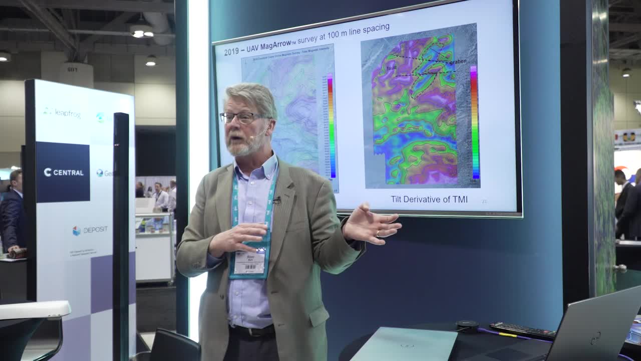
[00:23:47.480]And then I just did a quick interpretation of it
[00:23:49.970]to be able to say, I’ve interpreted these faults.
[00:23:53.660]I’ve interpreted those as grabens.
[00:23:57.420]Why that’s important and I’m going to say that
[00:24:00.210]we’re not seeing the actual Crestone Crater,
[00:24:02.360]but this survey was never designed to do
[00:24:04.200]the Crestone crater to actually map it.
[00:24:07.050]The first surveys were.
[00:24:10.770]This one was really to try to get the bigger picture,
[00:24:12.980]to get the better idea of where the structures were.
[00:24:16.208]And the reason for that,
[00:24:19.120]I’m going to give a little summary here.
[00:24:22.480]The 2017,
[00:24:24.230]the circular magnetic anomaly directly associated
[00:24:27.300]with the berm appears to be due to a magnetite content
[00:24:31.090]within the berm.
[00:24:32.660]Now, remember that the sands above the crater
[00:24:37.660]in this area are 4% magnetite.
[00:24:41.700]Why is there an increase in magnetite concentration
[00:24:44.630]at the berm, that’s one question.
[00:24:46.660]Are there other circular features of a similar origin,
[00:24:49.330]why are they existing? That was another.
[00:24:51.140]We saw that in our first data sets.
[00:24:53.620]2018, we indicated we were starting to see these two,
[00:24:59.180]these graben features and that they’re offset.
[00:25:02.040]And if they’re offset,
[00:25:03.050]they’re probably faulted and shifted over.
[00:25:06.530]So we think there was movement along that fault.
[00:25:09.910]That back in the day, paleo earthquakes along the fault
[00:25:13.650]may have created sand boils.
[00:25:15.830]Now you’ve got to realize that even today
[00:25:19.040]that is a known active fault system.
[00:25:21.310]So there are earthquakes all the time.
[00:25:23.920]Also back before people started populating
[00:25:26.740]the San Luis Valley,
[00:25:28.140]there was a very high hydraulic head
[00:25:30.650]in the groundwater so that the early settlers
[00:25:33.610]could walk out almost anywhere in the valley
[00:25:35.860]and all they had to do is poke a pipe in the ground
[00:25:37.990]and they got a little bit of a water geyser coming up.
[00:25:40.900]So they were able to essentially get artesian wells
[00:25:44.550]because the valley was actually doing, it was good.
[00:25:49.660]Now they’ve pumped it down a lot since then,
[00:25:51.240]so you’d never see that today.
[00:25:53.050]But what we think happens is that
[00:25:55.330]there was some paleo earthquakes
[00:25:57.003]that had enough energy to actually start
[00:26:00.570]causing some little geysers
[00:26:03.050]or little fountains of sand boils,
[00:26:06.740]bringing coarse-grained material from below
[00:26:10.000]and depositing it on the surface.
[00:26:12.330]And then in filling it with the sand,
[00:26:14.070]the magnetite rich sands.
[00:26:16.130]So that’s our current explanation of it.
[00:26:20.350]There are those that don’t believe that that,
[00:26:22.250]well, they haven’t probably heard this one yet,
[00:26:24.530]but there are those that still can think
[00:26:26.520]that this is a impact crater
[00:26:28.057]and there are those that think
[00:26:29.620]it’s just a windblown feature.
[00:26:34.330]So, but important to know is that because of this data,
[00:26:38.870]I actually have provided this data to a geophysicist
[00:26:45.034]at the USGS, who was curious about
[00:26:47.700]what is the source of these anomalies
[00:26:50.350]that he’s seeing in their air mag data over this area.
[00:26:54.440]And he thinks that it’s due to magnetite
[00:26:57.710]and we’re just seeing a topographical response.
[00:27:01.290]So I’ve given this data to him, we’re actually modeling it.
[00:27:04.790]So what we think is, let me back this up a little bit here,
[00:27:11.290]these features right here are all following,
[00:27:14.670]they’re low grade magnetic anomalies,
[00:27:16.850]and they’re all somewhat associated with topography.
[00:27:20.420]So what we think is that we do get a bit of a concentration
[00:27:24.050]of the magnetite rich sands
[00:27:26.000]a lot that is associated with topography.
[00:27:28.630]And that a lot of that response, not the graben response,
[00:27:33.450]but a lot of that other response
[00:27:34.790]is essentially noise sitting on top of our base level data
[00:27:41.500]due to the magnetite.
[00:27:45.570]Alright,
[00:27:47.160]conclusion, by applying different scales
[00:27:50.030]of UAV magnetic surveys from very high definition,
[00:27:54.650]which is the very tight space stuff to high definition,
[00:27:58.930]we have gleaned some new insights into geological structure
[00:28:01.760]leading to the conclusion that the Crestone Crater
[00:28:04.220]is most likely due to a sand boil.
[00:28:07.610]In addition,
[00:28:08.443]the magnetic data are reshaping our thinking
[00:28:10.720]about the groundwater recharge into the San Luis Valley.
[00:28:14.030]This is an agricultural area that has been over pumped,
[00:28:18.590]and it is very much a concern for the valley
[00:28:21.240]of how they’re managing our groundwater resources.
[00:28:26.600]Okay.
[00:28:28.040]Additional remarks.
[00:28:29.610]I’m not without additional remarks.
[00:28:32.710]First off,
[00:28:34.010]I want to point out weather is always the challenge
[00:28:36.110]that we’re up against most drone surveys,
[00:28:38.790]access to flight operations, staging locations.
[00:28:42.430]It’s an acronym I call a fossil.
[00:28:45.090]I hope that you will find that humorous, can be a challenge,
[00:28:49.950]locating where the pilot is can be a real challenge.
[00:28:53.340]Drones work well when the terrain is rugged
[00:28:56.060]or covered with wetlands,
[00:28:58.530]they also work in areas that aren’t rugged
[00:29:02.037]or covered with water.
[00:29:04.350]UAV magnetic surveys are scalable to fit the objective.
[00:29:07.360]That’s actually one of the points
[00:29:08.500]I want to really drive home is that
[00:29:10.360]because of the very portable and very flexible nature
[00:29:14.920]of actually designing and executing a survey,
[00:29:18.620]we could fly a survey with,
[00:29:19.930]let’s say a hundred meter line spacing
[00:29:21.990]and identify a feature that we want to get more detail on
[00:29:25.170]and immediately go in and actually fly a survey
[00:29:27.440]at 20 meter line spacing and maybe even lower.
[00:29:30.550]So that’s one of the real operational advantages
[00:29:34.236]of flying a drone magnetic survey.
[00:29:37.600]Drones are capable of longer flights are needed.
[00:29:40.720]Most of us in the business know that
[00:29:42.290]they’re actually coming to the market now,
[00:29:43.840]there’s commercial ones available,
[00:29:45.560]and some people build their own.
[00:29:47.710]And,
[00:29:48.543]but the current UAV that, the one that I’m using
[00:29:51.210]it does a really good job of getting it done
[00:29:53.640]and it’s at a price point that a lot of folks can afford
[00:29:56.280]to be in the business, but other sensors are needed.
[00:29:59.560]Other geo-physical sensors are needed.
[00:30:03.246]I’m learning about a few EM sensors
[00:30:05.500]that are now coming to the market
[00:30:07.320]or coming to folks have built them
[00:30:09.210]and they’re now available or will be available
[00:30:11.500]for commercial surveys.
[00:30:16.060]Let’s see, what else is there?
[00:30:18.380]Oh, this is the question of the day.
[00:30:21.070]Why do meteors always land in craters?
[00:30:25.950]Thank you for laughing at,
[00:30:27.260]I paid these guys to laugh at that, by the way.
[00:30:31.510]The next thing is
[00:30:33.130]I have been involved with
[00:30:39.909]the near surface technical section of the SEG.
[00:30:42.610]They are putting on a drone workshop at the SEG meeting
[00:30:49.210]this fall, it’s called Summit on Drone Geophysics.
[00:30:53.800]And it’ll be October 16th at the George R. Brown
[00:30:58.130]in Houston, Texas,
[00:31:00.070]I’ve actually talked to a number of the folks here
[00:31:03.000]who are going to come down and actually present
[00:31:05.343]in that workshop.
[00:31:07.700]There’ll be more coming if you want to get on my
[00:31:10.330]emailing list and let know about it,
[00:31:12.270]just give me your card and I’ll keep you apprised of it.
[00:31:16.600]So finally, thank you for your attention.
[00:31:20.360]You’ve been a great audience.
[00:31:22.310]I’ve got to work on my material
[00:31:23.810]and get a little bit more humor into it, but
[00:31:26.376]you’ve been a great audience and thank you very much.
[00:31:29.830]If there are any questions at this point.
[00:31:31.472](audience clapping)