


Autonomous, remote-controlled submersible gliders are revolutionizing undersea data gathering. Canada’s Institute of Ocean Sciences puts one through its paces.
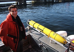
A strange-looking yellow ‘fish’ has been lurking the waters off the southern coast of Vancouver Island recently.
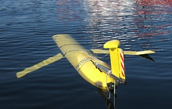
Named after the intrepid Nova Scotian Joshua Slocum who in 1898 became the first person to sail alone around the world, it’s called a Slocum glider. The 1.5-metre-long, 52 kilogram torpedo shaped vehicle is under evaluation by the federal government’s Institute of Ocean Sciences (IOS) out of Patricia Bay near Victoria’s International Airport. It’s a revolutionary autonomous underwater vehicle designed and built by Teledyne Webb Research of Falmouth, Massachusetts. Driven entirely by a variable buoyancy system instead of a propellor, it needs no mother ship for tethering or support. The evaluation project is a formal collaboration between Fisheries and Oceans Canada and the Canadian Centre for Ocean Gliders (CCOG).
The device is called a glider because it literally glides through water much like a sailplane glides through the air under gravity. A Slocum glider uses gravity to descend and buoyancy to rise; its wings providing the forward motion of about one kilometre per hour. The result is a sawtooth trajectory through the water. Because the only power it needs is for varying its buoyancy and running its electronics, the resulting long-range and duration make it ideal for long term data collection over large swaths of ocean. An onboard computer steers its rudder, the only external moving part on the machine. Patrolling for weeks on end, guided only by GPS and researchers’ commands, it surfaces periodically to transmit scientific data via satellite to the home office and take new GPS bearings before diving again. All for mere pennies a day in operating costs.
“At present, we are simply learning what the glider can do,” says Terry Curran, manager of client liaison for IOS. “I confess that my initial motivation was to help local industry build a business case for the vehicle. However, once we were able to add sensors to address biology in the water column, my personal interest has increased beyond the engineering aspects.”
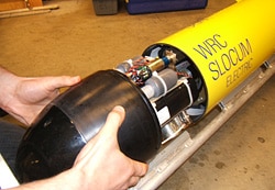
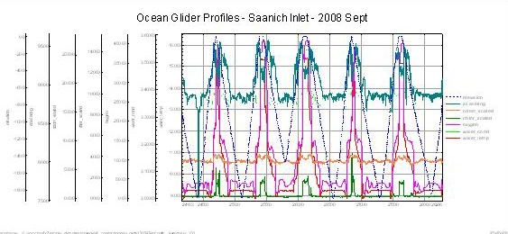
IOS’s glider is equipped with a Seabird CTD sensor (conductivity, temperature and depth), an Aanderaa dissolved oxygen (DO) sensor and an optical sensor to identify chlorophyll fluorescence, dissolved organic material, and particle scattering. “The CTD provides us with information about the water mass and the physics,” says Jim Gower, IOS research scientist. “And the DO and scattering sensors provide us with information about microscopic life in the ocean.” As it takes these measurements, the Slocum also records latitude and longitude.
“From the measurements of the physical properties of the water, one can detect different water masses and determine their extent,” explains Curran. Near surface salinity can be derived from temperature and conductivity. “The vehicle should be extremely good for this purpose, since it yoyos through the water column and can smoothly surface and descend – normally a tethered instrument is bounced about because of the waves and interpreting the measurements is difficult,” says Curran. The team has already produced extensive charts of salinity versus water depth and temperatures.
For nutrient studies, the researchers like to think of water as garden soil. “Life grows in the ocean if there is oxygen and light, hence the need for the DO sensor,” explains Gower. “The first signs of life are phytoplankton—free-floating plants. The presence of chlorophyll can be inferred by stimulated fluorescence. The [glider’s] scattering sensor does this, as well as making measurements of particle scattering and of dissolved organic material.”
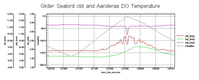
This image examines the timing between the depth sensor and the conductivity and temperature sensors. The pattern is very similar as the Glider ascends to and descends from the surface, and is symmetric about the zero-depth point. Thus, the timing between the sensors has been properly lagged (shifted).
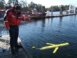
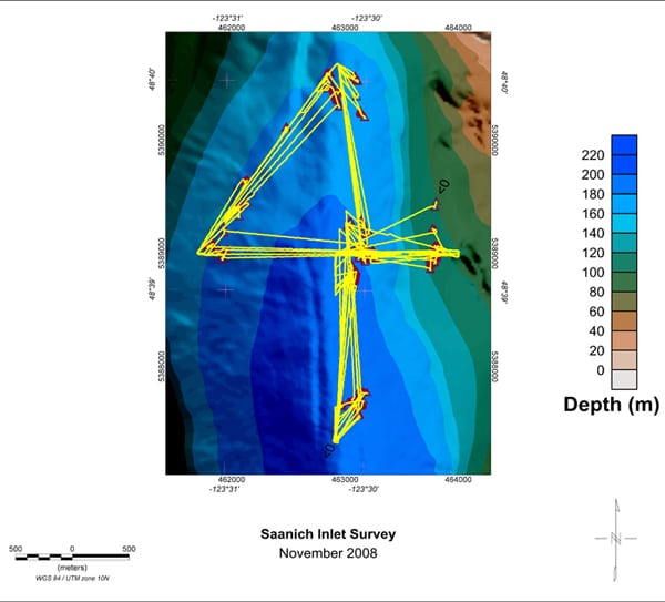
Until recently, most of the glider’s data-gathering trips had been local. But early this February the team launched the glider’s first long-distance foray—into the Strait of Georgia between Vancouver Island and the BC mainland. Due to the Fraser River’s freshwater outflow into the sea here, the area’s salinity had been posing ballasting challenges for the ocean scientists.
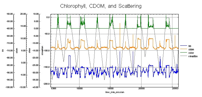
This image shows the relationship between the three optical scattering parameters (dissolved organic material, chlorophyll as sensed by fluorescence, and particle scattering, all as a function of depth. Chlorophyll is contained in the free-floating plant material (phytoplankton).
So it took a bit of fine tuning. “The vehicle manipulates its mass by only 400 grams or so,” says Curran. While the surface salinity is affected by the Fraser’s fresh water, at depth the water is saltier and colder, and therefore denser. “This means that we need to be very careful when we adjust the mass of the vehicle, literally by adding lead shot—too heavy, it will not rise through the surface fresh water, and too light it will not sink to its programmed depth.”
Once underway, Gower says a typical data sampling rate is once every four seconds. “This would be more than 20,000 records per day,” he estimates. “For three weeks, that would be over 400,000 records. And each of those records contains about 70 parameters, ranging from time and date and position, to the science measurements, to vehicle dynamics like roll, pitch, heading, depth, depth to bottom, water leak detection and communication by satellite telephone.”
Which all adds up to an impressive number of megabytes. No problem for their processing software, however, says Gower. “Simply put, Geosoft Oasis montaj is perfectly matched to the glider data. It can handle very large datasets quickly.” He lists off their needs that Geosoft handles: scaling readings into engineering units, adjusting channel-channel time lags, looking at various combinations of the 70 channels as time-domain profile plots, gridding the projected positioning information and then examining which measurements came from which lat-long-depth point, filtering data, extracting small portions of the time series to understand sensor behaviour, and creating plots for publication or presentation.
“The alternative is the Excel spreadsheet, which is easy to use for small data quantities,” says Gower. “However, it does not have the analysis power of Geosoft.”
“The vehicle has a scientific payload, and Oasis montaj is remarkable in its ability to graphically analyze a large dataset and a multitude of ocean variables,” sums up Curran. “It is a wonderful program to analyze the results.” As all the sensors have different response rates, they need to be best aligned in time using the Geosoft “lag gx” he says. “Because it is moving in three dimensions (latitude, longitude and depth), one really needs to jump from the sensor time series to a horizontal map to the database, to understand how things are related. I am also trying to do sensor transects, where I make maps of depth along a track, and gridding the data on this set of axes.”
When the glider proves itself on the Strait of Georgia shakedown cruise, the team’s excitement level will take a quantum leap for an upcoming trip: a probe of the Bowie Seamount, a Fisheries and Oceans Canada Marine Protected Area. It’s an ancient subsea volcano 180 kilometres west of Haida Gwaii (Queen Charlotte Islands) and a biologically rich area with high densities of sea life including Orca, humpback and sperm whales. “Bowie Seamount is a proof of concept mission for fisheries surveillance purposes,” enthuses Curran. He says for this mission they’ll be adding a hydrophone to the instrumentation.
“Bowie seamount is a fabulous place,” he says. “An underwater mountain 3,000 metres tall, that rises to within 25 metres of the sea surface. Unlike virtually all other seamounts on the west coast, it abounds with life.” And this life is fragile he adds: “If overfished, it could become a marine desert like the other [seamounts]. This explains why it was recently designated as a marine protected area, and why surveillance is needed.”
It will be a huge challenge, he reckons. “Simply navigating to a distant seamount 95 nautical miles from land, performing some listening experiments while circling the seamount, and then returning to port —all with a handful of D-cells as power— is a sufficient challenge!”
The Bowie Seamount probe could lead to development of surveillance duties for ocean gliders like the Slocums. “Other sensor packages could customize the gliders for different purposes,” says Curran. “Equipped with a hydrophone, the glider could listen for engine and wave-making sounds, and perform surveillance duties and report back via satellite. Areas closed to fisheries could be economically monitored for illegal activity.”
That’s just one example. “As we gain familiarity with the potential of this unmanned, untethered marine robot, I am expecting its use to radically improve our ability to perform coastal oceanography measurements in space and time,” says Curran.
Like their namesake, Slocum gliders have already racked up some impressive adventures around the globe. One in particular is thought to have broken a distance record for underwater gliders — over 5,700 kilometres. Launched on May 21, 2008 off the US east coast by Rutgers University researchers, the underwater marvel made it to within 20 kilometres of the Azores coastline when researchers lost contact with it on October 28th.
Records like this get attention from researchers worldwide. The latest was January this year when Teledyne Webb Research was contracted to provide Slocum Gliders to the NATO Undersea Research Centre (NURC) in La Spezia, Italy.
There will be new records. Already deployed by Teledyne is their next generation ‘thermal’ glider that can almost match Joshua Slocum’s 19th century endurance. This new design utilizes differences in ocean temperatures to source its energy via a thermal engine so needs even less internal power. The Slocum Thermal glider can dive two kilometres under the surface and travel transmitting data for five years before returning to port. With its 40,000- kilometre range, a Slocum Thermal glider could theoretically circle the world alone like Joshua did too.