


Five ways geoscience and geophysical surveys are unlocking secrets around the world.
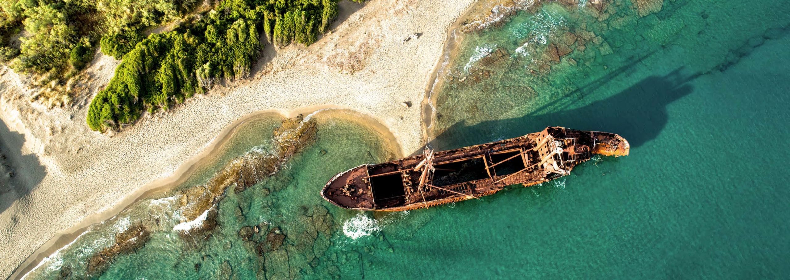
1.Finding lost ships
In search of historic wrecks consumed by sand
In 1776 the 450-ton Dutch slave ship Meermin ran aground off Africa’s Cape Agulhas after the 140 slaves on board revolted in a bid for freedom. The Meermin was lost in sand banks and to history, but remains a significant moment in South Africa’s past.
Traditional efforts to locate the wreck have proved fruitless, but an airborne magnetometer survey was able to identify 22 potential locations (anchors, cannon and iron fastenings give distinctive signatures). Further analysis of the data revealed anomalies such as a ship’s keel, helping to identify the six sites most worthy of investigation.
After more work was done to determine the depth of sand deposits over the targets, those sites were excavated and… not one turned out to be the Meermin. Yet such was the accuracy of the interpretation that every one of the six revealed a previously unknown wreck ranging from the late 18th to late 19th century. The final resting place of the Meermin remains elusive, but geoscience may yet track her down.
2.Unearthing Ancient Scrolls
Mapping earthquake shattered caves to throw light on an old mystery
In Israel, the Cave of Letters achieved fame in 1960 when a horde of papyrus scrolls were discovered, dating to 153AD. But further discoveries have been hindered by the condition of the cave floor, which is littered with boulders dislodged by earthquakes. Using an Electrical Resistivity Tomography (ERT) scan, it recently became possible to finally determine where the original cave floor lay and continue the exploration. The use of ERT in the area has also revealed a city beneath a city – the Iron Age remains of a settlement below the first century AD city of Beithsaida. And further geophysical surveys have located two burial sites that could offer important clues about the authors of the region’s famous Dead Sea Scrolls, long a question of debate.
3.Water for Refugees
Hunting new sources of water free of volcanic contamination
The UN’s Kakuma refugee camp in Kenya was relying on just a dozen wells to serve 163,000 people. Not only was the supply inadequate but it had heavy fluoride concentrations. Geophysicist Paul Bauman concluded that the UN’s practice of using one dimensional electric soundings to spot fractures in the underlaying volcanics and sink wells was contributing to the unacceptable fluoridation levels. Tracking down water in the thick overburden gravels would be a better alternative, he believed.
However, the complex geology and hydrogeology of the area called for a more modern geoscientific approach to locate the sand and gravel aquifers most likely to produce clean, fresh water. Bauman and his team ran the equivalent of 11.4km lines of ERT to differentiate fine materials from coarse and fresh water from saline. A simultaneous seismic refraction survey totalling 5.8km lines helped to determine the top of the bedrock and the thickness of the overburden. Compiling data in Seequent’s Oasis montaj identified high priority targets for drilling. The work produced sustainable water yields of 29-45 cubic metres per hour – enough to supply 57,000 refugees with 20 litres of good water every day.
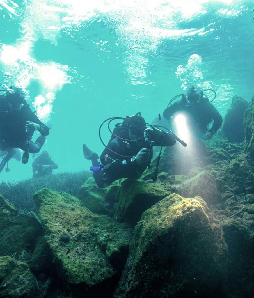
4.Patrolling underwater caves
Keeping tourism and local welfare in balance
The cenotes – natural sinkholes – of Mexico’s Yucatán Peninsula lead to the longest underwater cave system in the world. They’re a constant draw for tourists, but are also inextricably linked to the welfare of the local people as the aquifer is the sole source of freshwater in the region. While tourism supports the local economy, it also presents two simultaneous threats: an increase in the extraction of water by hotels and higher levels of sewage.
To understand and address these issues, an airborne EM survey was commissioned to map the flow of freshwater through the sinkholes. However, the project also made possible by hundreds of tourists working as amateur geoscientists, without knowing it.
Over the decades, divers had mapped 262 underwater caves and 1140km of underwater passages. Along the way, many had also made biological, archaeological and environmental observations, and even taken water chemistry samples. Overlaying their records on the airborne data and bringing it all together enabled an objective assessment to be made of two totally independent data sets. This contributed to a far more comprehensive understanding of the hydrogeology. Monitoring this vast system with greater accuracy will be invaluable in ensuring the region can continue to attract tourists while reducing the impact on groundwater quality and availability.
5.Measuring ice movements
Tracking ice velocity to understand melting glaciers
Researchers from University of California, Irvine and NASA’s Jet Propulsion Laboratory have been using SAR phase interferometry to map the speed of ice movements in the Antarctic. Surface ice velocity can reveal a lot about how glaciers and ice sheets are changing, and the resulting impacts on sea level rises. Previous maps have only been able to cover around 20% of the continent, but the new SAR research, published in July 2019, boosted that to 80% with ten times more accuracy than previously possible. The team combined inputs from six different satellite missions from 1994 to today and used it to track details such as visible patches of dirt on the ice surface.