


Flowing through central London, the River Thames is a potentially dangerous confluence of human activity and unexploded ordnance (UXO) leftover from WWII.
So when workers found a 50 kilogram German bomb in the riverbed near the Houses of Parliament during civil engineering works earlier this year, bridges were closed, roads cordoned off, and the Royal Navy and police called in to remove and safely detonate the device.
SAND Geophysics worked alongside the Port of London Authority (PLA) Hydrographic Service to resurvey the River Thames for unexploded bombs leftover from WWII. Shown above is the Maplin, the PLA’s newest survey vessel.
As a further precaution, the site developer hired SAND Geophysics to work alongside the Port of London Authority Hydrographic Service to resurvey the area. SAND, a geophysical consultancy formed in 2014, uses a combination of multibeam and sidescan imagery, magnetic gradiometry and GeoChirp 3D surveys to identify UXO buried below sea and river beds.
In this case, SAND provided the state of the art GeoChirp 3D, a sidescan sonar and transverse gradiometer and their expertise. The Port of London Authority provided the survey platform and a hi-resolution multi-beam echosounder fitted on their newest survey vessel Maplin.
GeoChirp 3D is an acoustic imaging system developed by the University of Southampton and Kongsberg GeoAcoustics to provide high resolution imagery of the top ten metres of sediment. SAND had already been working with the university and the Port of London Authority on commercial applications of GeoChirp, and was surveying the Thames to demonstrate its usefulness, when the bomb was discovered.
“The Thames is a notoriously difficult area to survey with traditional magnetic techniques because of its busy nature and high level of construction,” says Richard Hamilton, who founded SAND geophysics with three friends from university whose expertise ranges from nearshore to deep sea oil and gas surveys. “Previous approaches have focused on identifying surface targets, but we’re able to provide an additional dimension by looking at the size, shape and exact depths of buried ferrous and non-ferrous targets.”
Hamilton says a key component of SAND’s approach is the integration of all of its datasets to provide a higher level of confidence in the results, reducing both the number of necessary diver investigations and the safety buffers required around the targets.
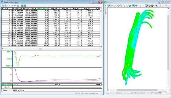
Geosoft’s Oasis montaj and UXO software is well suited to this task, and proved to be particularly effective in the Thames project, where vessel traffic and ferrous structures create false anomalies and changing tides play havoc with buoyed sensors. The software easily finds and removes false anomalies from the dataset, while its upward continuation tools can correct all the sensors to a common altitude during processing.
In this case, the resurvey confirmed that there were no other UXOs in the vicinity of the engineering works and construction was able to resume with confidence that the workers would be safe.
Hamilton appreciates the ability to subscribe to Oasis montaj to suit their project needs. “The Geosoft subscription model means that when we have a project like this, we have access to the latest versions and can cherry pick the tools we need,” he says.