


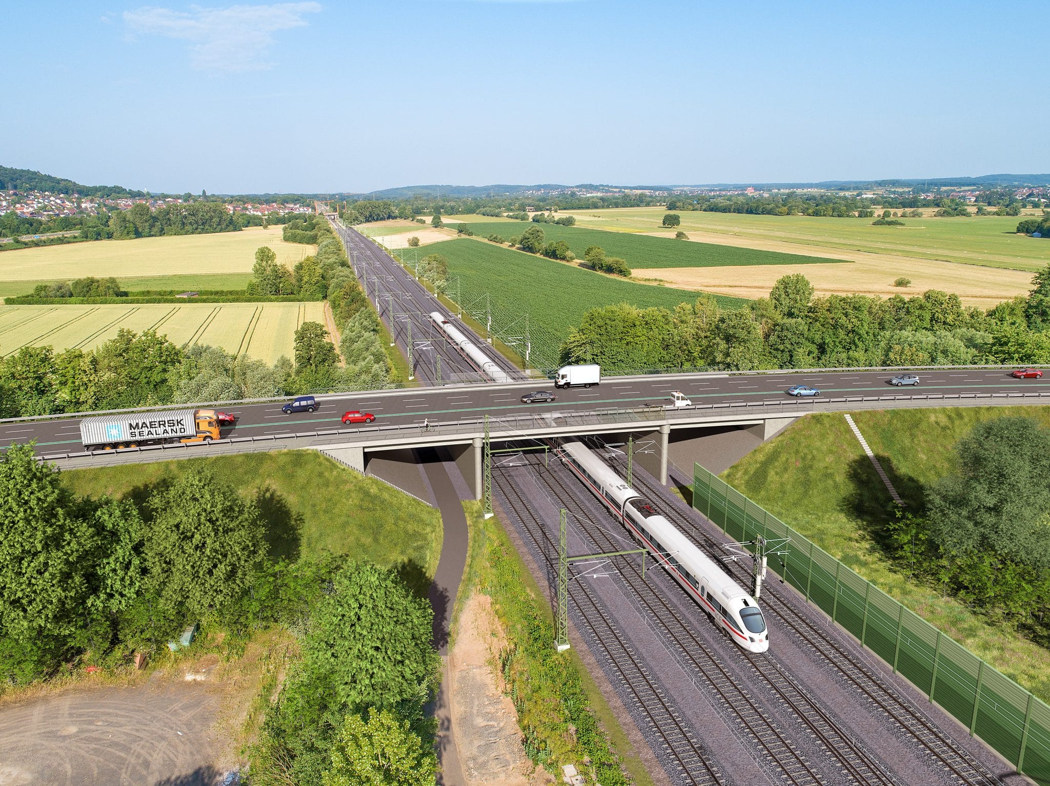
A new high-speed traffic line in Germany, will eliminate bottlenecks and shorten journey times to serve an increase in passengers along the Gelnhausen-Fulda railroad line. With two-thirds of the approximately 100-kilometre investigated route options running in tunnels, designers faced multiple complex subsoil, data and coordination challenges to create their 3D geotechnical models.

Prof. Quick und Kollegen Geologist, Thomas Schneider, talks us through their project to determine an optimal high-speed rail route option and explore the technical feasibility of tunnels (Video credit: Prof. Quick und Kollegen).
To accommodate an expected 30% increase in passengers by 2030, a new double-tracked rail line is being built between the cities of Gelnhausen and Fulda, northeast of Frankfurt, Germany. The new high-speed traffic line comes with its benefits, but challenges, too.
Specialist civil and geotechnical engineering consultancy, Prof. Quick und Kollegen was commissioned by Deutsche Bahn Netz AG to determine an optimal rail route and explore the geotechnical feasibility of tunnels, while protecting the local environment and community.
”We conducted subsurface investigation for two possible routes, approximately 50 kilometres each, with about two-thirds of the total 100-kilometres running in tunnels, says Thomas Schneider
Faced with multiple complex subsoil, data and coordination challenges to create their 3D geotechnical models, Schneider and the team realised there was a need for BIM workflows in a connected, collaborative data environment.
Leveraging Seequent’s PLAXIS and Leapfrog Works, they built a 3D ground model to develop a common understanding from which to perform accurate geotechnical calculations.
“With Bentley and Seequent’s innovative, integrated 3D ground modelling technology our entire project can achieve the highest possible standard of productivity, efficiency and safety with the best ecological and economical solutions,” says Schneider.
240 km/h
The high-speed line (up to 240km/hr) will accommodate an expected 30% more passengers by 2030.
9.5km
The longest tunnel between Schlüchtern and Mittelkalbach runs a distance of 9.5 kilometres.
15 layers
Over 100 boreholes explored and 15 lithological layers created, including a fault system of 88 fault blocks.
Creating a BIM digital workflow
With a focus on the geotechnical feasibility of tunnels, Prof. Quick und Kollegen’s subsurface exploration involved coordinating and assessing multiple sources of information including drilling, geophysical surveys, boreholes, and laboratory testing.
“Through our field investigations and official archival records, we gained good geological insights to help us understand the underground of our project area. However, this information was only available in 2D format and often only viewed in isolation,” said Schneider.
One crucial reason for choosing Seequent 3D technology was that it enabled the team to digitise the exploration of over 100 boreholes and create 15 lithological layers across an incredibly complex fault system.
“Accurately representing the complex subsoil to include all 88 fault blocks was a major concern for our team,” Schneider explains.
“We were unsure if any software – even Leapfrog Works – would have the capabilities but were excited to discover it did and the Bentley and Seequent teams worked closely with us to tackle this challenge.”
“With Leapfrog, we could link the tectonic layers with our geological profiles to verify information from the drillhole and geophysical investigations while paying particular attention to all the fault lines that interact with our railroad lines,” he says.
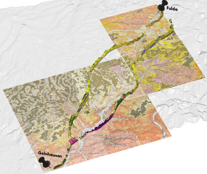
The team created a digital workflow using Bentley and Seequent solutions to model two approximately 50-kilometre-long railroad line options from Gelnhausen to Fulda in Germany (Image credit: Prof. Quick und Kollegen).
The benefits of a seamless digital workflow
Schneider and the team made use of the interoperability between Bentley’s PLAXIS 2D and Seequent’s Leapfrog Works to accurately run through their geotechnical calculations.
“For greater precision, we imported the digital terrain and integrated topography drone scans into our 3D model. And used geological maps and official borehole information to create georeferenced profiles, aligned with the planned railroad routes,” said Schneider.
“We were able to continuously integrate the groundwater measurements into our subsurface model to create an attributed groundwater model as a source of monitoring and for further calculations.”
”“As a significant portion of the routes weave through tunnels we also used our model to define tunnel positioning within the subsurface. Additionally, we employed the cut-and-fill method to define excavated material quantities and manage any potential risks,” he said.
The outcome was a highly detailed subsurface 3D model (including cross sections, long sections and alignment serial sections) that comprehensively captures the 200-metre area alongside the railroads.
“We now have an accurate digital twin of the two railroad line options, within a seamless digital workflow and a common, collaborative data environment that is accessible to all project stakeholders that can continue to support all stages of the project,” said Schneider.
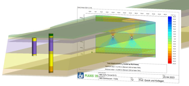
A 3D model showing the interoperability between Leapfrog Works and PLAXIS 2D to determine the geotechnical deformation within the subsoil in the area of the planned tunnel tubes. (Image credit: Prof. Quick und Kollegen).
Managing resource and risk to minimise community and environmental impact
Introducing BIM methods for geotechnical engineering is a pioneer project for Schneider and the team at Prof. Quick und Kollegen. They expect to see many more advantages of using Bentley and Seequent technology as the Gelnhausen-Fulda project progresses.
“Already, the positive effects can be seen in the clear communication between internal and external project participants which – in addition to lively exchange – also results in time saved,” Schneider says.
“ [This] has brought significant changes to the way projects are approached. By consolidating all necessary information into a single, transparent 3D model, accessed via a cloud-based data environment, everyone works with more motivation and with a simpler, more streamlined daily routine,” he says.
”While the new high-speed railroad project goals include managing the growing number of passengers and preventing traffic congestion, being able to also plan the geotechnical feasibility of tunnels plays a crucial role in better managing resource and risk and minimising impact on people and the environment, he adds.
“Overall, the tunnels will help preserve nature and ensure that communities are not adversely affected as they will significantly reduce the noise from goods traffic across the local towns and villages.”
“We hope our Leapfrog story helps motivate other geotechnical engineering companies and teams to also adapt their way of working to BIM methods so that they, and especially the environment, can benefit from the same advantages,” he says.
Prof. Quick und Kollegen were finalists in the Subsurface and Modelling category in Bentley’s prestigious 2023 YII Going Digital Awards in Infrastructure. Geologist, Thomas Schneider and the team were recognised for leveraging Seequent’s PLAXIS and Leapfrog Works, to establish a BIM workflow and 3D model, for a new high-speed railway line in Germany.