


For those explorers who hunt for oil and gas, there was a time when gravity and magnetic surveys were considered the coarser, rougher first cut to zero in on the best locations to set up their seismic gear. That’s all changing now. Increasingly, gravity and magnetic (grav/mag) methods are being used to complement and constrain traditional seismic data or even used as the only tool.
There have been reported successes in the Gulf of Mexico applying combinations
of 3D gravity, full tensor gradient, magnetic modeling and inversion.
Wintermoon Geotechnologies of Denver, Colorado is a consultancy that has specialized in the grav/mag field, using these geophysical techniques and blending them with seismic to achieve greater success in oil and gas exploration. What’s behind this success? “Gravity and magnetic data quality has improved significantly since the 1980s,” says Dr. Michal Ruder, Wintermoon’s president. “Not only can we acquire data more quickly now, but also our data resolution is much better and we can now resolve more subtle (lower amplitude and shorter spatial wavelength or high frequency) perturbations in both the gravity and the crustal magnetic fields. This improved resolution now allows us to imagine very small-scale and shallow lateral variations in density and magnetic susceptibility.” She says these are often associated with the hydrocarbon play itself. “Modern gravity and magnetic surveys can now provide a set of observations that is more directly associated with hydrocarbon play character, in addition to the ‘traditional’ regional information for which we have long used potential field data,” she says.
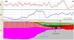
An example of 2D modelling of gravity and magnetic data using Geosoft GM-SYS
across the Santos Basin from GETECH’s non-exclusive
‘Geodynamics and Petroleum Geology Study of the South Atlantic Margins’.
Previously difficult geologic settings can now be explored in detail using gravity and magnetic methods for situations where traditional seismic alone has been less successful. Ruder explains why. “Seismic data quality is not uniform in all geologic settings,” she says. “Due to their elastic properties, some rock lithologies do not readily transmit acoustic energy. As a result, seismic signals can be greatly attenuated, providing little or no seismic imaging below these acoustically-challenging horizons.” Where there is a significant lateral density variation below the problematic acoustic horizon, she says gravity can provide unique information about these rocks, primarily because gravity is not negatively impacted by rock elastic properties. In general, independent geophysical techniques linked to the same lithological model will respond to different geophysical properties, like density, susceptibility or resistivity, so their integration can be valuable.
A common imaging problem for seismic operators where grav/mag can enhance the geologic picture is where there is a near-vertical fault or interface (like a salt or shale diaper). “Seismic signal is typically scattered by these interfaces,” says Ruder. “In contrast, both gravity and magnetics have their best imaging at vertical interfaces across which lateral density or magnetic susceptibility contrasts exist.”
In fact, for oil and gas explorers, some geologic situations almost demand that gravity and magnetic methods be used; where they can become an indispensable boost to seismic explorations. Reducing the uncertainty in interpretation of complex sub-salt reservoirs is a case in point. Ruder has had considerable success using the approach in the salt-prone basins offshore West Africa, South America, North America and northern Europe. “Gravity methods are vital for providing an independent corroboration of total volume and shape of salt when investigating sub-salt hydrocarbon potential,” she says. “Seismic data quality can be significantly improved when we use gravity modeling results to improve and refine our seismic velocity model of the base of salt. This result is fed back into the seismic pre-stack depth migration processing to provide an improved seismic image of the sub-salt horizons’ geometries.” She adds that this ultimately leads to more successful prospecting.
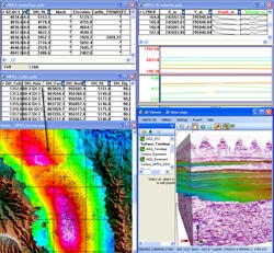
Field scale gravity modelling: 3D time SE G-Y with seismic interpretation,
over 1000 wells with downhole logs and logged formation tops.
Indeed when it comes to subsalt interpretations, advancements in and integration of techniques have been largely responsible for the massive deep offshore hydrocarbon discoveries of the past decade. Examples from several regions show where multi-disciplinary 3D modeling helped to delineate allochthonous salt distributions. In many cases, e.g. where the base of salt could not be clearly identified from seismic data, the integrated approach revealed its geometry and salt thickness, a major step for better imaging of target structures below salt.
As many as five or six different techniques can be integrated to optimize salt geometry interpretations. Savvy operators have reported successes for example in the Gulf of Mexico applying combinations of 3D gravity, full tensor gradient, magnetic modeling and inversion, using such constraining data sources as seismic, magnetotellurics, gravity and borehole data. Qualitative and quantitative interpretations have provided good control of salt location and volume. Moreover, interpretation of high-resolution gravity and seismic depth imaging has produced significant increases in resolution of complex geometry images of salt structures. The significant savings gained in cost and time are proving invaluable—as well as the vastly improved odds of accurately identifying geological targets.
But seismic techniques remain indispensable: precious few oil and gas discoveries are made without the use of seismic methods. However, other geophysical methods can assist with more reliable evaluations in these deeper, more challenging environments. Gravity and magnetics will never trump seismic completely; nor entirely replace it—they’ll continue to be complementary tools. “Gravity is correctly characterized as a ‘low-resolution’ geophysical exploration tool,” says Ruder. By cost-effectively gathering geophysical data to narrow the search area within large fields, oil and gas explorers can refine their targets and apply seismic techniques more productively. “Without constraining information, a gravity model can be modified in an infinite number of ways in order to match the observed gravity signal. Seismic, well log, and other geologic data provide critical constraining information for gravity models, limiting the degrees of freedom of our modifications and enabling us to produce a meaningful, constrained earth model that is consistent with both gravity and seismic datasets.”
It makes interpretation more rewarding but not without new challenges. Ruder uses a multi-faceted approach to interpretation. “We work hard to identify and separate ‘regional’ and ‘residual’ signals within the observed gravity and magnetic datasets using our state-of-the-art Fourier-based 2D filtering routines,” she explains. “We construct models which incorporate geometries and physical properties derived from all available geologic and geophysical data, and we then invert the observed gravity and magnetic data to gain further insight into the geologic question at hand.” She says she’s used the approach successfully in prospect evaluations in the Gulf of Mexico, and offshore Brazil and West Africa.
None of this could be accomplished without a good suite of software. Most geosciences consultants prefer to work in multiple software environments dictated by individual project needs or client preferences. Ruder employs a full and diverse set—for data entry, data processing, data enhancement and quantitative modeling; so a seamless interface is one critical consideration. She says using Geosoft as a major part of her software suite makes this easier, for example it has the ability to ensure compatibility with ArcGIS, which she and others use extensively. It allows direct import of her grav/mag data for constraining the seismic. Ruder likes the fact that it goes both ways. “I can take my Geosoft products and move them into the ArcGIS world or open up an ArcGIS map project in Geosoft.”
As the use of gravity and magnetics in oil and gas exploration advances, it can even tell itself whether it will work or not. To see if gravity and magnetics will help answer her client’s geologic question, Ruder often uses Geosoft GM-SYS. Somewhat ironically, it is gravity and magnetics themselves that tell her the feasibility. “It can be used in two important phases of our projects,” she says. “The first is as a sensitivity model. There are certain geological settings where gravity and magnetics won’t work. Using GM-SYS to construct a theoretical model to test that sensitivity of the tool in a particular geologic setting will help us determine whether it’s even worthwhile to do a gravity and magnetics acquisition of data. That means we are asking a question that gravity and magnetics can answer, that is, can we go ahead and do the project? Assuming our results of the sensitivity testing indicate that grav/mag will provide the required insight and the project moves forward, we then use GM-SYS to build our constrained earth model of the survey data.”