


The extensive Karoo Basin of South Africa may hold vast reserves of shale gas. A tectonic modelling project underway will help determine their production viability.
South Africa is hoping to join the world’s ‘tight’ gas rush with reservoirs of its own. Regions the world over from Australia to Poland to British Columbia are discovering and exploiting these types of gas reserves, thanks to the game-changing techniques of horizontal drilling and multiple-stage fracturing.
Shale gas is a new hot topic in South Africa, where the main focus has previously been on mineral exploration. I wanted to do a project that is more geared towards petroleum exploration.
Stephanie Scheiber-Enslin
With just 183,000 barrels per day of total oil production in 2011—which includes synthetic liquids from coal and natural gas (most of that imported)—South Africa is domestically energy-deficient. Imports averaged a further 427,000 barrels per day just to meet the country’s growing demand. This, along with rapidly increasing electricity demand, has prompted ambitious government plans to expand its energy sector.
Development of Karoo Basin gas reserves, if viable, could be the solution. An April 2011 estimate by the US Energy Information Administration puts South Africa’s technically recoverable shale gas resources, mostly in the Karoo, at 485 trillion cubic feet—over half the size of the US’s. If developed, much production would likely be slated to extend supply to the Mossel Bay gas-to-liquids plant, already the world’s largest.
But so far explorers haven’t even had a conclusive tectonic model of the basin for starters. Geophysicist Stephanie Scheiber-Enslin is addressing that: creating a model for her doctoral thesis at Johannesburg’s University of the Witwatersrand.
Her project is certainly a timely one. “Shale gas is a new hot topic in South Africa, where the main focus has previously been on mineral exploration,” she says. “I wanted to do a project that is more geared towards petroleum exploration.” Two of her doctoral supervisors (Susan Webb, of University of the Witwatersrand, South Africa and Jörg Ebbing, of the Department for Petroleum Engineering and Applied Geophysics at Norwegian University of Science and Technology and Norwegian Geological Survey) had already started some work on the project.
The project is well-supported: funding is provided by South Africa’s National Research Foundation, and administered by the Council for Geoscience. Geosoft Africa has been supporting her research by providing Geosoft software for the project over the past few years.
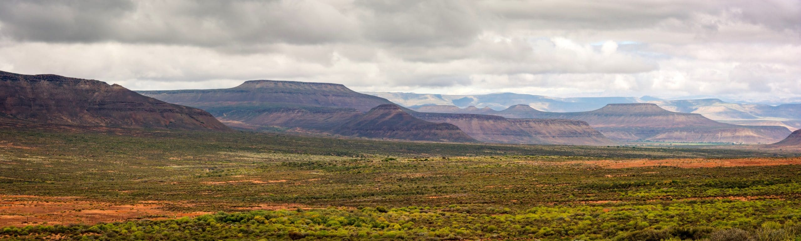
Her work is cut out for her. The Karoo Basin is a broad arid plateau covering much of South Africa’s interior. The plateau is supported by the stable Archean Kaapvaal Craton in the north and several surrounding Proterozoic basement blocks in the south, and formed within the continental interior of Gondwana between the Late Carboniferous and Middle Jurassic. The main basin covers about 700,000 km2, though scientists have suggested it was at least double that size during formation, with a current maximum thickness of roughly 12 km in the southeast. Several opinions and hypotheses about the nature of the subsidence that resulted in basin formation have been proposed: some consider it to have formed as a retro-arc foreland basin, while others have shown that geological and geophysical data do not support that theory. All have implications for the tempting shale gas formation within it.
By building the model of the southwest Karoo Basin, Scheiber-Enslin will be able to better approach these questions. She’ll be creating a 3D geological model of the Karoo Basin that will be used to investigate the tectonic environment of the Karoo, and the dynamic formation of the basin in terms of the flexural response on and off craton, and the possible formation of natural gas deposits.
It’s a real exercise in integration of diverse data sources. Her study is based on seismic and potential field data, and constrained using surface geological and structural information, magnetotelluric data, deep boreholes and Moho structure from teleseismic data; as well as magnetic depth-estimate methods to provide depth and boundary solutions.
Some of these sources are useful but are not high resolution. The Council for Geoscience of South Africa for example have collected and compiled gravity data since 1939, much of which is concentrated along roads with spacing stations of 14 km with barometric heights. However, “these Gravity data corrections have recently been reviewed and updated by the Council for Geoscience, improving the correction for atmospheric and height,” says Scheiber-Enslin.
In the 1970s, the Council for Geoscience began collecting and compiling aeromagnetic data too. The earliest surveys were flown using proton precession magnetometers, with a nominal 150 m flight height, 1 km flight line and 5 km tie line spacing. Mean aircraft speed was 240 km/h, resulting in a ~50-100 m along-line sample interval. In the 1980s, new Cesium-vapor magnetometers provided shorter cycle times and better along-line resolution.
“In addition, kilometres of seismic data collected in the region in the 1970s were recorded on paper reams and have passed hands over the years,” she says. “Thankfully, Falcon Oil had the data scanned and digitized.”
Scheiber-Enslin says the seismic and MT profiles she’s using are more recent: part of the Inkaba yeAfrica, Agulhas-Karoo Onshore-Offshore Geoscience Transect. The Agulhas-Karoo Transect consists of a ~600 km onland section across the Kaapvaal Craton, Karoo Basin, Cape Fold Belt and Kango Inlier, and a ~400 km offshore section over the southern continental margin of Africa. Onland datasets comprise ~240 km of wide-angle seismic refraction data, ~600 km of magnetotelluric data and ~100 km of Near Vertical Reflection (NVR) seismic data, all acquired between 2003 and 2006.
She explains that most studies of this nature use a basic uniform elastic plate to model flexure, but she wants to gain new insight into the possible evolution of the basin on and off the stable Kaapvaal craton. To understand how the mechanical strength of the continental lithosphere varies and how this affects the burial depths of sediments on and off the craton, she’s considering variations in rheologies and flexural responses to loading—important implications for shale gas formation.
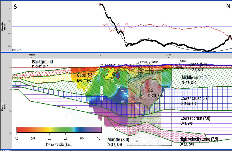
As a step towards the model she has created a number of 2D potential field (gravity and magnetic) profiles using Geosoft GM-SYS. “Due to the regional nature of the gravity database being used and the non-uniqueness of potential field models, I used other data such as teleseismic, seismic and MT to constrain the model,” she explains. “Moho depth values and crustal structures for the model were derived from various published sources and imported into GM-SYS as background images for use while modelling horizons.”
She had hoped to use the Werner Deconvolution, Analytic Signal and Euler Deconvolution depth estimate built into Geosoft Oasis montaj to define the magnetic basement of the basin but found the basement is not significantly magnetic. “And there is the added complication of ~180 Ma Karoo basalt dykes and sills that have been emplaced at multiple levels throughout the Karoo basin,” she adds.
“These intrusions are magnetic and result in shallow signals that dominate the depth estimates, making deeper depth estimates difficult,” she says. So calculated depth estimates were loaded into the 2D GM-SYS models as symbols and compared with seismic and MT images. “Some correlation with seismic layers was possible,” she says. “The Geosoft tilt derivative was used to output solutions that were then used to run Fortran code that calculated the tilt depth from the magnetic data, again showing up a variety of depth including the basin and dolerite intrusions.”
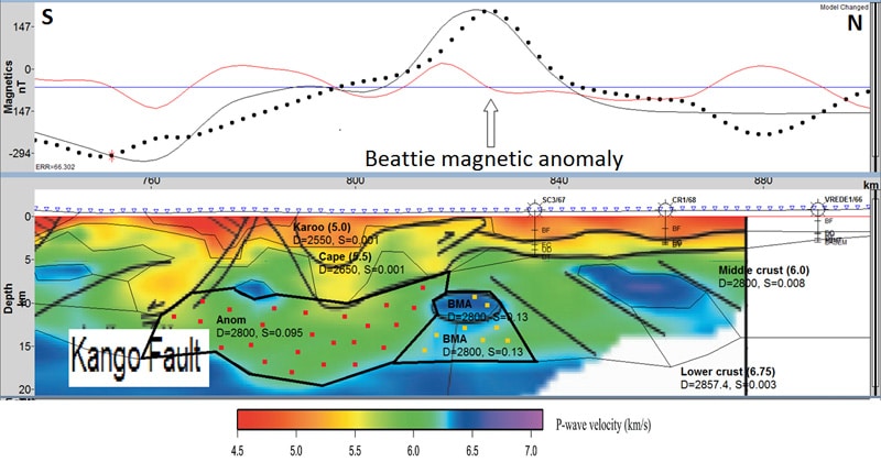
While conducting research for the study, Scheiber-Enslin also established a need for updated potential field models to better constrain the source of the Beattie magnetic anomaly that crosses a large section of the southern part of South Africa from west to east. “I am currently trying to see how existing seismic and magnetotelluric data can be integrated with both magnetic and gravity data to test current theories as to the cause of this body, by including the body in my 2D profiles,” she says. So far she has found they correlate relatively well (on a kilometre scale) and provide a realistic geological model for the Beattie magnetic anomaly in the south of the study area, something that has not previously been attempted. “This model can now be used to constrain a source for the anomaly,” she says.
With success in the complex data integration process, she’s now gradually closing in on the tectonic model. “As part of the next stage, the two GM-SYS 2D profiles will be combined into a 3D model of the southwestern Karoo basin,” she says. “I have used the Geosoft regional and residual isostatic gravity calculations to help identify anomalous crustal or mantle bodies that will be included in the 3D model.”
She’s had her share of challenges. As well as the age of the gravity data, the older magnetic data isn’t of particularly high resolution. “It would be ideal to have higher resolution data to allow us to better image the numerous dolerite dykes and sills that intruded at multiple depths within the basin after the basin formed,” she says.
Another shortcoming has been the availability of consulting expertise. “There are a limited number of research geophysicists in South Africa whose brains we can pick,” says Scheiber-Enslin. “The majority of geophysicists move on to industry jobs.” Also, because exploration in South African has always been more mineral-focused, there are few geophysicists with experience in basin exploration. “Thankfully though, my supervisor in South Africa (Susan Webb) was already collaborating with Jörg Ebbing in Norway [thesis supervisor], who works in basin research at the Norwegian Geological Survey.”
She has plans to present the new model at a global geophysical conference. Doubtless there will be many exploration geophysicists and companies paying close attention.