


Mexico’s Yucatán Peninsula has long been a popular tourist attraction and for various reasons. These include welcoming beaches, fascinating Mayan ruins, and of course, the cenotes, which consist of beautiful sinkholes or openings that expose the groundwater and lead to the longest underwater cave systems in the world.
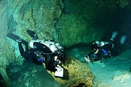
EM mapping of the cenotes has benefited from data collected by cave divers over many years of exploration. To date, divers have mapped 262 underwater caves and cave systems, for a total of 1138.4 kilometres of underwater passage.
But the cenotes are more than just a tourist attraction for swimming, snorkelling, and diving: The aquifer is the sole source of fresh water in the region. This has posed a serious challenge for ongoing development and prompted a local non-profit group, the Amigos de Sian Ka’an, to commission an airborne EM survey to map the flow of fresh water underground. The survey was flown by the Geological Survey of Austria on helicopters provided by the Mexican military. The collected data were then analysed by Dr. Yusen Ley-Cooper, who is now a research scientist with Australia’s Commonwealth Scientific and Industrial Research Organisation (CSIRO).
As Dr. Ley-Cooper explains, the aquifers face two simultaneous threats.
“One is that sewage is being pumped into them [aquifers are underground layers of material from which ground water is extracted using a well]. The other is that hotels and the local, growing population have a requirement for fresh water and so are extracting from these aquifers. And because the cenotes are near the coast, if you over-extract, you end up drawing in salt water, further contaminating the water supply.” This survey, flown with a frequency domain system at a 200-metre line separation, had an unusual ancillary database against which to cross-reference its results: A detailed set of maps of the network already existed – the result of data collected by cave divers over many years of exploration, which have been archived by the Quintana Roo Speleological Survey (QRSS) .
Dr. Ley-Cooper explains that the diver-collected data was a stroke of serendipity.
“There are several divers’ associations who have, over several decades, mapped the underground water pathways as part of their goal to encourage conservation and awareness of the underwater caves and cenotes of Quintana Roo through collaboration and knowledge.”
To date, QRSS divers have mapped 262 underwater caves and cave systems, for a total of 1138.4 kilometres of underwater passage. They’ve also collected water chemistry samples and biological, archeological, and environmental observations of the caves.
“These findings have been incorporated into a number of different fields of research. They constantly push the limits and go further and further, trying to map and expand the network,” adds Dr. Ley-Cooper.
Last year, the divers managed to connect two networks which previously seemed not to connect, making this part of the Yucatán the largest karst environment in the world.
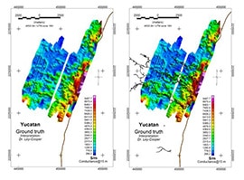
Fig.1 Left panel shows airborne EM conductivity depth map (conductance) at 15m below surface produced using conductivity depth transform EMflow. On the panel of the right the same image has been overlaid by speleological ‘Cenote’ routes mapped by cave divers (black dendrtic pattern). Brown line to the east of the map delimits the coast line.
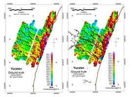
Fig. 2 Left panel shows airborne EM conductance now a t a deeper depth of 20m below surface. The map on the right has been overlaid by speleological ‘Cenote’ routes mapped by cave divers. A salt intrusion can also be clearly delineated by the higher (red to pink) conductance values pushing its way through on the east side of the coast line.
Fig. 2 Left panel shows airborne EM conductance now a t a deeper depth of 20m below surface. The map on the right has been overlaid by speleological ‘Cenote’ routes mapped by cave divers. A salt intrusion can also be clearly delineated by the higher (red to pink) conductance values pushing its way through on the east side of the coast line.
“We’re very grateful to the divers for the years of information they’ve been recovering,” says Dr. Ley-Cooper. “We overlaid their records on to the airborne data so that an objective assessment of two totally independent datasets could be made.”
He notes that a major advantage of airborne EM is that data are collected at multiple frequencies. Each sounding allows the geophysical team to discern responses at varying depths. “You can actually say, for example, this is at approximately five or ten or fifteen metres to the resolution of the instrument in a particular survey site.”
This type of survey produces a vast amount of data to manage and process. Dr. Ley-Cooper, who used Geosoft Oasis montaj for the task, says people sometimes don’t appreciate the scale of the challenge. “Each airborne EM survey has thousands — potentially millions — of soundings, and each sounding has a position, an altitude reading, and different channel responses from that point. What Oasis montaj does really well is handling the database and gridding the airborne EM data.”
Though the cost of this type of survey varies significantly with the boom-bust commodity cycle, Dr. Ley-Cooper feels there are ample benefits to the technique for groundwater management. Airborne EM can cover large areas in a short timespan, potentially reach depths of hundreds of metres, generate a 3D model of the target region’s water-bearing layers, and be easily integrated with other data for an even more comprehensive understanding of the hydrogeology. This makes the technique an excellent tool for mapping aquifers, monitoring groundwater salinization, or planning new water wells, as well as other hydrogeological applications.
Dr. Ley-Cooper adds that if a partner provides the necessary aircraft –as the Mexican military did in this case– then the expense is reduced considerably, putting this powerful tool within reach of hydrogeologists and planners.