


Statoil implemented a centralised and organised system for gravity and magnetic data management, utilizing Geosoft server technology, which both specialists and generalists can use. We want to “use all the data we have,” said Christian Gram, geophysicist with Statoil, speaking at a Finding Petroleum forum in Stavanger on “Transforming Subsurface Interpretation”.
“You have to be able to find [the data], know the value of it and know how to handle it.”
There are 200 potential users of the data, based around the world. The data is also used by GIS (geographical information system) users. The company has about 3200 gravity and magnetic data sets, and 60 gigabytes of data. It also has many pdf reports, and data showing which areas have been surveyed.
The company uses satellite gravity data, which can provide structural information below the deepest interpreted seismic horizon, including calculating crustal thickness.
Statoil would like to use all available high resolution data for 3D forward modelling of complex salt structures. Another application of these high resolution data is the quality checking of velocity cubes/models. By forward calculating the gravity effect of a density cube (derived from a velocity cube) it can be compared with the observed high resolution gravity data.
Project background
Before the project was implemented, the company basically relied on people’s memory to remember which areas were covered by data, Gram said.
Statoil could use a Norwegian Geological Survey system to find out file numbers, and then copy the data from its own system.
It was difficult to find metadata information, such as which projection system was used, Gram said. The data was stored on a number of different drives. It was basically only available to specialists.
People were always asking if the gravity data existed, and then staff members had to search for it, which took up a lot of time.
With the growth in increase in gravity and magnetics, “the number of requests for data increased, and started to entrench on our specialist interpretation work,” he said.
People would discover data but not know if it was something new or a duplicate of something already known about, he said.
The data management project started in 2005 with a project to develop a clear system for publishing and archiving data, led by Gram and a colleague.
Using the system
With the new system, based on Geosoft DAP server technology, the data is available to all Geosoft or ArcGIS users, and available in a standard industry format for gravity and magnetic data.
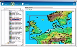
You can search for the data by geographical co-ordinates, or by country, or both at once. You can also search using Geosoft’s Oasis montaj mapping system or ESRI ArcMap.
You can download the data directly into your projects. “You basically overlay it, in 2D view on your seismic as a pseudo horizon, at the right depths and the right scale,” he said.
All relevant information is entered via the Meta Data Editor when submitting files, such as data source, format, resolution, and projection. Further, if it is confidential, country, a short abstract, and data purpose. “If you leave out data from the projection system the data set cannot be published, it forces you to do it properly,” he said.
The administrator can check the file properties and cell size. The administrator can also preview the data. The data is only ‘published’ once it has been checked by an administrator.
There is a server administration tool which makes it easier to archive and publish the data. The datasets are managed using Microsoft’s SQL Server Management Studio Express. Statoil is also looking at integrating Geosoft’s DAP server further with ESRI data sets.
In future, the company might add electromagnetic data. Statoil expects that its future explorationists should have a ‘minimum awareness’ of how to use and utilise gravity magnetics data, he said.
Adapted from an article published in the Digital Energy Journal.