


Archaeologists use geophysics to focus their search for a historically important Dutch slave ship wrecked off the Cape in 1766
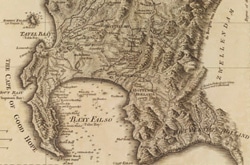
At the southern tip of the African continent about 175 kilometres southeast of Cape Town lies a wetland estuary system which has been of considerable interest to BirdLife International for preserving the breeding grounds of the endangered Damara Tern. But this complex system, the southernmost estuary in Africa, is also of considerable interest to archaeologists and historians, especially near the mouth of its main river, the Heuningnes.
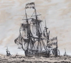
Two hundred and forty-three years ago, in March 1766, the 450-ton Dutch slave ship Meermin (“Mermaid”) ran aground off Cape Agulhas near here after her cargo of 140 Madagascan slaves revolted in a valiant bid for freedom. A series of events culminating in an unsuccessful attempt to man the Dutch East India Company (VOC) vessel resulted in her drifting with no anchor and hitting a sandbank. Authorities recaptured most of the slaves, but the master shipwright sent from Cape Town to inspect the wreck declared the Meermin a write-off, citing extensive structural damage. Already the shifting sands had begun to build a sandbank on the vessel’s stern side. Any useful goods were removed, much of them auctioned right on the beach and she was left to the whims of the capricious shifting sands.
The Meermin has captured the attention of historians. She was a hoeker, a type of ship with 14th century roots. The name is derived from the ships’ design function: using baited hooks on lines to catch cod and haddock. The first hoekers had just one or two masts, but in the 17th century the VOC built several as cargo carriers with three masts—the Meermin was one of these rare models.
Popular with the VOC for a short period from about 1665 to 1670, the hoekers’ construction allowed it to withstand the warping effects of the eastern waters better than the ‘fluits’ – the ship type of choice until then. “The VOC stopped using hoekers towards the end of the 17th century,” explains Jaco Boshoff, maritime archaeologist at Iziko Museums of Cape Town. “But they constructed some periodically mainly for use at their colonies as multi-purpose vessels.” He says four hoekers were constructed in the second half of the 18th century for the Cape service. “One needs to add that vessels stationed at the Cape were used for multiple tasks like transport of timber from Table Bay to False Bay, the provisioning of the various company outposts and then of course for obtaining slaves especially from Madagascar,” he says. “In fact the request for a new vessel from the government at the Cape in 1759 to their masters in Holland mentions the slave trade with Madagascar as one of the main functions for the new vessel.”
Boshoff says the historical significance of the Meermin grounding event and what it means for a South Africa in transition had not been recognized or received any attention until recently. So about five years ago, the Meermin Project was launched by Iziko Museums of Cape Town. “The project is important in the context of a changing South Africa and what meaning it should have for maritime archaeology for the country,” he says.
He has his work cut out for him. “The area where the wreck of the Meermin is most likely to be found is in the mouth of the Heuningnes estuary as it is the only river mouth in the bay,” he says. The problem he faces is that the estuary has changed massively since the time of the grounding, including some due to relatively recent man-made changes. “In 1939 the then Department of Forestry started with a dune reclamation project in the Heuningnes estuary area,” he explains. “It was at the behest of the local farmers as the river mouth used to close up periodically, flooding the hinterland and destroying crops and grazing areas.” The region had already been known for its dynamic sand movement patterns, but with the reclamation project the river mouth became restricted to one location in order to prevent it from silting up. “It’s a different environment from the one of 1766,” he says.
This creates several problems for archaeologists searching for the wreck. Complicating the search is the fact that there have been several wrecks historically recorded in the area and none has an accurately described location. Moreover, the river mouth has closed up several times in the past and reopened at different locations. “Its historical position varied from two kilometres to the west to 1.6 kilometres to the east of its current position,” says Boshoff. “Nowadays it is restricted to an area of about 500 metres.”
A marine magnetometer survey to locate the wrecks was first attempted but proved of limited value: very shallow waters near the coast preclude small watercraft from approaching within 200 metres of shore. An airborne magnetometer survey became the tool of choice. Flying on board a Cessna navigated by SATLOC GPS, with a Geometrics 823 Cesium vapour magnetometer having an instrument resolution of 0.001 nT and a total noise envelope on collected airborne data not exceeding 0.5 nT sampled at ten times a second, data were collected. “A SATLOC real-time differential GPS recording once a second to an accuracy of less than three metres in X and Y and five metres in Z was utilized,” explains Boshoff. Flying at 130 knots at a height of 30 metres above ground, lines were spaced 40 metres apart while data were digitally recorded. He says a base station for differential correction wasn’t needed. “It records its position relative to the WGS84 [World Geodetic System 1984] Spheroid. This can be converted, if required, to other popular co-ordinate systems.” At the start and end of each flight, the pilot flew over a known point to verify the GPS position, which was plotted out after each day’s flying.
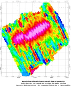
The airborne survey delivered 22 potential targets, most of them on the beach. As the data at first were provided on contour maps only, “I contacted Anglo American Corporation South Africa and they analyzed the data with Geosoft Oasis montaj,” says Boshoff. “What I liked about it was firstly the fact that I could download a viewer without purchasing the program, enabling me to read the processed data. As an archaeologist and not a geophysicist it was a learning curve made easier by montaj magnetic intensity maps.” Through the analysis done in Geosoft they were able to eliminate several of the targets as unlikely or of natural magnetism.
For the layman, Boshoff explains how magnetic anomalies can arise from wooden ships. “Iron fastenings were used extensively in wooden ships,” he says. “This combined with the possible presence of anchors and cannon give fairly good signatures.” He says even when objects like cannon and anchors are not present one can still pick up the fastenings that seemed to give a good signature as an assemblage rather than individual objects.
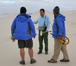
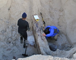
The data thus processed from the airborne survey revealed that 11 of the 22 targets—six on land and five underwater—had potential to be the Meermin. The six land targets were further investigated using a highly sensitive handheld magnetometer to get a more accurate picture of each wreck. “We used a Geometrics G-858 Walkmag with Trimble GPS and post processing of the positions to get it to differential,” says Boshoff. Line spacings depended on the size of the target but were typically two metres over each target. Again, Oasis montaj was used to process these data. “What the Geosoft gradient maps showed us was phenomenal,” he enthuses. “In one case we had a longitudinal anomaly that turned out to be a ship’s keel.” Signatures were incredibly accurate he says. They used the gradient maps to decide where to excavate, “which was no small matter as most of the wrecks were under three to four metres of sand.”
So the next step was to determine the depth of the sand deposit over the targets. This was done using a water probe system whereby seawater was pumped through a four metre long steel pipe. “The sand depth on most sites was found to be between three and four metres,” says Boshoff. “This presented a serious difficulty as shoring up an excavation is dangerous and not feasible in a wet sand environment. One has to keep in mind that these sites can only be accessed during spring low tide. Your window of operation is therefore limited to a maximum of three to four hours.” This was clearly not doable so a backhoe was brought in. There was little chance of damaging the wrecks. “As we knew how deep the deposit on any given site was, it was relatively easy to control the action of the backhoe,” explains Boshoff.
It’s a measure of the signature accuracy from Geosoft that, using the backhoe, all six targets revealed wreck assemblages. None was proved to be the Meermin but all were previously unknown wrecks, ranging in date from late 19th century to possibly late 18th century, judging from construction details.
How did they know none of the wrecks was the Meermin?“We are fortunate that a ship’s draft for the Meermin exists in the collection of the Netherlands Maritime Museum in Amsterdam,” says Boshoff. “This draft is one of the main tools for identifying the wreck of the Meermin as we can use the construction details and compare them with the wreckages found.” Another strategy they use is analyzing the wood, as they know what types of timber the Dutch used in their ship construction. For example, “most of the wrecks found so far have been mainly pine construction. This is evident in all the construction details sampled including outer hull planking, frames, knees and keelsons,” he says. “If a wreck is predominantly pine it rules that wreck out as being the Meermin. Only two wreck assemblages have any evidence of oak, but unfortunately so far, they do not measure up as the structures do not fit the measurements on the draft.”
There’s still much work to be done on these new finds. “We have not quite established the identity of the wrecks, bar one that was indicated on an old chart,” says Boshoff. “One is potentially very significant as it could possibly be that of another slave ship that wrecked in the area in 1794.” He says further analysis such as DNA and dendrochronology [tree ring dating] might prove or disprove that assumption. However, as with most archaeological projects, more funding would be needed to complete these tests.
With six of the 11 promising targets excavated, there now remain the five underwater sites to investigate and narrow the search for the Meermin. For these, Boshoff says they’d like first to do an airborne gradiometer survey to help with more accurate positioning and higher target resolution. The finer resolution will be more important for the underwater sites than were the land sites, as they hope to use a diver operated magnetometer to run across them.
As the potential sites are ticked off, excitement grows. “We hope to do the gradiometer survey at the beginning of 2010 and a follow up field survey towards the end or middle of 2010 as funds, weather and other external factors allow,” says Boshoff.