


If ever there was a candidate for accurate site characterization, the contaminated parcel of land that will host the London Olympics in 2012 is it. Lurking below the site’s surface is a mix of unexploded bombs, radioactive waste and industrial toxins that pose serious obstacles to redevelopment.
Selected for its proximity to central London and good access to transport, the 500-acre site in the Lower Lea Valley of East London has been the centre of industrial activity for years. Aside from the resulting industrial contamination, the site could contain as many as 200 bombs that failed to detonate during the Second World War as well as radioactive nuclear waste dumped there in the 1950s.
As a result, the subsurface will need to be carefully remediated to the tune of £1.7 billion before construction of an urban park – the largest to be built in Europe in the last 150 years – begins.
But although the Olympic Delivery Authority is already preparing the site for remediation, the British Geological Survey (BGS) says the subsurface should be thoroughly investigated first to prevent expensive, potentially dangerous and/or environmentally damaging mistakes.
The characterization would not only help Olympic planners, but would direct future development in the surrounding area, one of the many brownfields slated for regeneration worldwide as the trend towards urbanization continues apace.
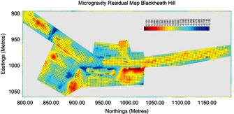
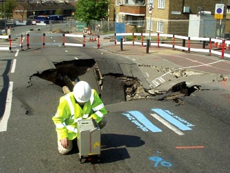
Residual Microgravity Map of a region of the Roman Road (A2) into London showing areas where Chalk was excavated after the Black Death in the C15th some of which have recently collapsed.
“Investment now in the management of geo-information and the development of 3D geological models of the shallow subsurface will provide benefits not only to the development of the Olympics but for the development of the whole of the Thames Gateway for decades to come,” say researchers from the BGS in a recent issue of Geoscientist.
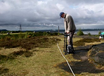
While the BGS is mainly concerned with geology, geophysical techniques routine in mineral exploration could be used to detect both natural and manmade features beneath the surface of the Olympic site. The properties of density, elasticity, magnetic susceptibility, electrical conductivity, and radioactivity that identify mineral deposits can also provide a snapshot of the urban subsurface including dangers such as unexploded ordnances and nuclear waste, sources of contamination, or remnants of earlier structures that could cause engineering challenges.
Rapid advances in 3D modelling software allow these properties to be displayed in a meaningful way to non-geophysicists involved in regenerating and developing urban brownfields, allowing them to pinpoint problems and target their remediation accordingly.
Yet, civil engineers continue to rely on much more expensive, and potentially more disruptive, borehole drilling to characterize brownfield sites, even though problem areas between drill holes are often missed using a conventional grid pattern.
“I’ve waged a 20-year campaign to try and convince engineers not to reach for the drill, because drilling can be like trying to find a needle in a haystack, says Peter Styles, Professor of Applied and Environmental Geophysics and Geography at Keele University in the United Kingdom. “But engineering is driven by litigation in this country, and it is defensible in court to investigate using drilling on a grid. So that is the conventional technique, even if it is not always the best technique.”
Styles points out that even if geophysics cannot replace drilling for legal reasons, it should at least be used to target the drilling so that discrete hazards, such as hidden cavities, are not missed and exposure to toxic chemicals is minimized. The survey findings can also help compliance with environmental legislation surrounding clean-up of contaminated sites. And detect those unexploded bombs without setting them off.
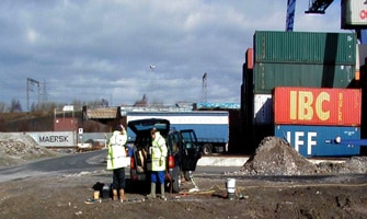
For example, Zetica, a London-based site characterization firm consulting on the Olympic site, used non-invasive geophysical techniques to identify the source and pathway of serious contamination below the site of a major car park development in central England. Previous drilling had failed to detect the contamination, but within half a day, Zetica had identified a sump containing volatile waste as the source, and a concrete culvert as the pathway. The culvert was closed and the sump removed before redevelopment got underway.
Styles says the choice of geophysical technique is site dependant. If information about the subsurface is scanty, a first pass with electrical resistivity to detect contamination and find the water table, gravity to detect cavities or underground storage tanks, or ground-penetrating radar (GPR) to detect buried pipelines, power lines, and even hazardous liquid wastes is advisable.
“You have to have a first good guess at where these objects are before you use more sophisticated techniques,” he says. “Techniques like electrical resistivity, gravity and GPR have been really useful tools for homing in on areas.”
Often investigators will use a combination of methods to reflect the complex nature of the urban subsurface: electromagnetic techniques to detect changes in conductivity and find fault zones; spectral IP to trace hydrocarbon contamination; magnetic profiling to detect buried ferrous objects such as unexploded ordnance and archaeological artefacts; radiometric measurements to locate faults or caves or to map contamination; and seismics to characterize fill material.
Increasingly, geophysicists are combining not only technique but interpretation. For instance, Styles might mix gravity data with electrical data and view them in a mathematically integrated way to detect contamination within an underground cavity. Advancements in GIS and 3D modelling facilitate this integration by providing a means to visualize several different types of data at once. Styles says time domain techniques are also becoming more popular as urban planners recognize the importance of not only detecting contamination and other obstacles to brownfield development, but monitoring those hazards as they change over time: migration of contamination, for instance, or the expansion of an underground cavity towards the surface.
Applying geophysical techniques traditionally used for oil and mineral exploration to the urban environment is more advanced in Europe and the UK, where land shortages are more acute than in North America.
“In the UK, we’re running out of space,” says Styles. “We’ve been through our industrial cycle and we are starting to dismantle our gas works, our chemical works, and our factories and rebuild on top of them. Almost all land which becomes available for building in the UK has a previous industrial history.”
But the practice is starting to catch on in North America, where more and more people are gravitating to urban centres. In Canada, the number of people living in metropolitan areas jumped by 45% between 1971 and 2001, more than three times the rate of growth of rural areas.
Brownfields are providing the space to house these new urban dwellers, while geophysical techniques are helping to detect unexpected surprises below the surface, prevent project delays, and allow better estimates of remediation costs.
A purchaser who wanted to redevelop a parking lot in an unspecified downtown core, for instance, was able to calculate the cost of removing contaminated soil from the site, and therefore adjust the purchase price, by using a combination of electromagnetics, resistivity and test pits to characterize the subsurface, according to Mundell Associates, an environmental consulting firm based in Indianapolis, IN. At another Mundell project, cost estimates for waste removal from a brownfield redevelopment dropped from US$1 million to US$550,000 after the company completed geophysical surveys over the site. Final removal numbers were within 5% of the revised bid.
However, using geophysics in the urban environment is challenging because the anomalies are often subtle while the surrounding clutter is loud. Overhead power lines, rebar in concrete, electrical lines in buildings and electrical currents can interfere with measurements.
To minimize the effects of this “cultural noise”, researchers at a brownfield site in East Chicago concluded that line and station spacings should be one foot or less, instruments should run in orthoganal directions, and a combination of methods should be used. But more work is needed at the data interpretation stage to weed out these distractions.
“My vision is to be able to take a model of the city and do all the corrections for it so that we can remove those effects from what we want to look at,” says Styles.
References
Holt, J., Daniels, J., Vendl, M., Baumgartner, F., and Radziviscius, S (1998). Brownfield Site Investigation Using Geophysics: A Case History from East Chicago. In Proceedings: SAGEEP 1998 Environmental and Engineering Geophysical Society.
Mundell, J. A., and Buyer, G. B. (2002), Geophysical Characterization of Brownfield Sites for Better Development Evaluation and Construction Planning. In Proceedings: SAGEEP 2002. Environmental and Engineering Geophysical Society.
Royse K., Entwisle D., Price S., Terrington R. and Jo Venus (2006). Gateway to Olympic Success. Geoscientist 16 (5)
Styles, P. (2003) Environmental geophysics: a site characterization tool for urban regeneration in the post-mining era Geology Today 19 (5).