


In areas with limited accessibility and/or a scarcity of outcrop, airborne geophysical techniques can sometimes be used to map geology. Gamma-ray spectrometry, for instance, works well in granitic areas because granites tend to have relatively high levels of gamma radiation from the decay of potassium, uranium and thorium.
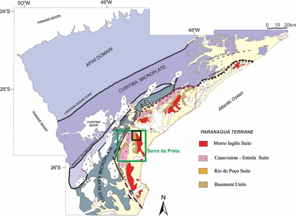
Fig. 1 – Geological map of the meridional portion of the Ribeira Belt with the Paranaguá Terrane highlighted in red, the Serra da Prata ridge in green, and its northern portion in black (Modified from Cury 2009).
Researchers at the University of Paraná in Brazil recently tested the application of gamma-ray spectrometry for geological mapping in an area of southern Brazil that contains a variety of granitic rocks. At the same time, they evaluated how topography changes and landslides affect the mobility of radionuclides in rugged or mountainous regions. They published their results in the Journal of Applied Geophysics (2016) in a paper titled Gamma-ray spectrometry of granitic suites of the Paranaguá Terrane, Southern Brazil.
The Paranaguá Terrane lies along the southern segment of an orogenic belt that runs for 1400 kilometres along the Atlantic coast of Brazil (Fig. 1). The area is understudied because of its lack of outcrop, thick cover and inaccessibility. It is characterized by an igneous complex containing granites that formed 620-570 million years ago. The average altitude is 1200 metres above sea level, with some peaks reaching 1800 metres.
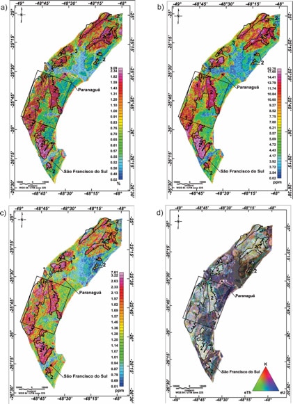
Fig. 2 – Gamma-ray spectrometry maps of the Paranaguá Terrane: K(a), eTh(b), eU(c) and ternary(d), indicating the granitic suites: Canavieiras – Estrela (1), Morro Inglês (2) and Rio do Poço (3), according to Cury (2009). The rectangle indicates the sub-area of Serra da Prata ridge in black.
The research area is highly susceptible to mass movements, partly because of the drainage geomorphology and partly because of the abundance of rain. The landslides expose scars of fresh rock that have higher concentrations of radionuclides than the areas around them, but also transport the radionuclides to lower elevations where they would normally not occur in significant concentrations.
The researchers used a geophysical survey over the area flown by CPRM, the Geological Survey of Brazil, using a line spacing of 500 metres and a mean clearance of 100 metres. They transformed the data to apparent concentrations of potassium (K, %), equivalent in thorium (eTh, ppm), and equivalent in uranium (eU, ppm). Readings were taken every second, representing sampling intervals of about 75 metres.
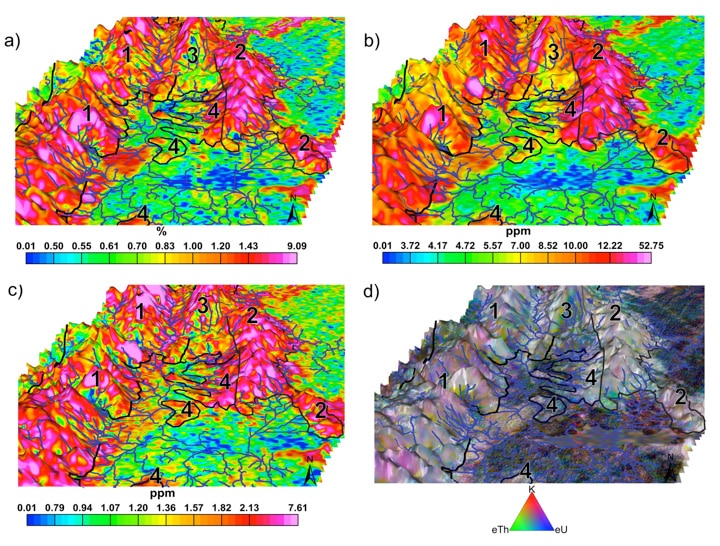
Fig. 3 – 3D gamma-ray spectrometry maps overlapping the DEM of the Serra da Prata ridge (see location in Fig. 2). K(a), eTh(b), eU(c) and ternary(d). Canavieiras – Estrela (1), Morro Inglês (2) and Rio do Poço (3), Rio das Cobras (4).
They used Geosoft Oasis montaj to process the resulting gamma-ray spectrometry data. They corrected the data by assigning minimum values to the K, eU and eTh data. After ensuring the quality of the data, they interpolated the dataset in square grids of 125 metres and created basic and ternary maps that they superimposed on a digital elevation model (Fig. 2).Then they performed a statistical analysis to compare the airborne geophysical data with lithogeochemical information in the literature.
The researchers also analyzed radionuclide mobility across the topography by integrating geophysical, geomorphological and geological data with the geophysical data. Using the 3D application in montaj, they created 3D models to evaluate how topography controls radionuclide mobility (Fig. 3). Professor Francisco Ferreira, a lead researcher on the study, says the contour application was also useful because it gave them the ability to draw contour maps of the gamma-ray spectrometry anomalies that they could compare with the scars from mass movements.
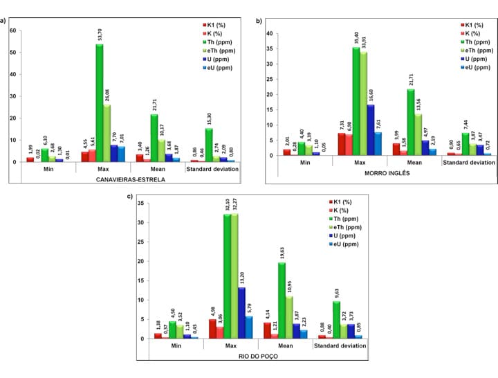
Fig. 4 – Comparision of the lithogeochemical and gamma-ray spectrometry data from the granitic suites of Canavieiras – Estrela (a), Morro Inglês (b) and Rio do Poço (c). The lithogeochemical and geophysical data are represented by K1, Th, and U and K, eTh, eU, respectively.
“We verified clearly the petrographical similarity through the statistical comparison between lithogeochemical and gamma-ray data from the granitic suites,” says Ferreira (Fig. 4). “We also concluded that the mobility of radionuclides should always be taken into consideration, especially when you have a rugged topography, in order to avoid erroneous interpretation caused by false anomalies.”
More information on the study is available on ScienceDirect.