


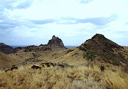
Its geology complicated by volcanic intrusions, the East African Rift System challenges oil and gas explorers.
Around 45 million years ago, spreading like a gigantic crack the length of Africa, the East African Rift System (EARS) began slowly splitting that continent into east and west, starting in southern Ethiopia/northern Kenya. As it progressed over the next 40 million years, clastic sediments and episodes of volcanic extrusions moved in and progressively infilled newly created basins. In today’s form, the rift’s exposed escarpments have been a literal gold mine for anthropologists in their search for early hominids.
But for geologists and geophysicists on the prowl for oil and gas, it’s not such a smorgasbord. Deep in these basins are thought to be significant reservoirs of oil for countries like Kenya, but those basalts and other volcanic extrusives seriously challenge and complicate seismic work.
It was the anthropological treasures that first brought Dr. Jean-Jacques Tiercelin of UMR CNRS 6118 “Géosciences Rennes” at France’s Université de Rennes here. “My story with the East African Rift started with a field trip into the Afar depression of Ethiopia in October to December 1975 as a young researcher at CNRS [Centre National de la Recherche Scientifique], with the International Afar Research Expedition (IARE) conducted by paleontologists and geologists who are by now well known,” he recalls. It was an exclusive group: anthropologists Don Johanson from the US, Yves Coppens from France and Maurice Taieb, a geologist from France; Tiercelin had joined just following their discovery of the famous skeleton known as Lucy. As the group had no stratigrapher, and Tiercelin was also a sedimentologist, CNRS kept him on.
That sedimentological expertise soon took him into oil exploration. Tiercelin integrated an academic research program in the area with French oil giant Elf Aquitaine. It was a natural for him. He says the sedimentation in rift basins are analogues with oil-rich sedimentary series relating to the opening of the Atlantic Ocean such as those drilled in West Africa, both onshore and offshore. “The first targets of this program were the small lakes of the central Kenya Rift, mainly Baringo and Bogoria lakes,” he recalls.
He maintained his interest in the anthropology of the region while working in the Turkana depression, “looking at the complex evolution of these basins and especially the problems relating to the interference between the Sudan Rifts, the Anza Rifts, and the Cenozoic Kenya Rift,” he says. “Behind this complex question was the question of the hydrocarbon potential of this area, as a consequence of the demonstrated high hydrocarbon potential of the Sudan Rifts.”
Which made the hydrocarbon prospects in these basins most tantalizing. “Up to now to the best of my knowledge, no economically valuable oil discovery has been made in the Turkana depression including the Lotikipi Basin,” says Tiercelin. More exploration wells would certainly help—he notes that just two have been drilled in the area. “One well, the Loperot-1 drilled by Shell in the Lokichar Basin has demonstrated the presence of thick organic-rich shales, and oil was recovered at some depths in the well, but not with commercial interest,” he says. Nevertheless, he believes it’s an exciting prospect.
Rift basins in other areas of the world have demonstrated high potential for hydrocarbons, says Tiercelin—China, offshore West Africa to name a few. “The Lake Albert major discovery is also a major indicator,” he says. “But one [problem] with the East African Rift is the presence of abundant volcanism in the basins, particularly in the Kenya Rift.”
Moreover, surveys are limited by the largely unknown geology of EARS; it is still relatively understudied. “In my opinion, we know just 10-20 % of the geology and evolution history of the rift,” says Tiercelin. “It is probably much more complex that we think. There are so many questions. Only deep geophysical investigations coupled with exploration wells will permit [a full] understanding.” Not just a well here and there, but a real geophysical and drilling survey on an international scale is needed, he says. “That would be my dream.”
So far, it’s still a dream. But a project undertaken in the rift’s Lotikipi Basin has creatively pulled together and integrated available data from several sources. The basin lies under the Lotikipi Plains in the Turkana Depression of northwestern Kenya. The project was conducted by Andrew Long, Technical Analyst at Geosoft Africa Pty Ltd. and Francis Njuguna from the National Oil Corporation of Kenya (NOCK).
The data they had to work with consisted of a series of time migrated 2D seismic reflection sections, an independent airborne gravity survey acquired in 2007 (with over 90,000 measurements), and a 1986 ground surveyed (5,000 stations) gravity interpretation. The airborne survey had line spacings between 10km and 25km, with five tie lines. Other data sources included public domain satellite imagery, a surface geological outcrop map and some previous literature. There were some shortcomings: the airborne gravity survey data didn’t include all the required definition to perform a full processing routine starting from the raw gravity data; and the survey was not originally acquired for the purpose of basin exploration so didn’t coincide with the 2D seismic line survey.
As the East African plateau has been shown to be regionally but not locally isostatically compensated, “this complicates the use of residual gravity in modeling the area,” Long says. “The episodes of volcanic activity over the geological record have expelled thick mafic igneous sequences that render conventional seismic reflection techniques difficult to interpret.” Basalts are strongly absorbent of p-wave energy, he explains, and hence they act as high impedance barriers to high frequency waveforms travelling through their structure, as well as causing scattering and attenuation.
Another challenge says Long was finding all the requirements for the petroleum prospect, namely the source and its maturation, the seal, the reservoir quality and migration pathway. “For the Lotikipi region source maturation is a key issue,” he says, “but the aim of this exercise was to help define basin structure to encourage further exploration and definition of the potential petroleum traps.”
Geosoft Oasis montaj and the geophysical modules employed enabled Long and Njuguna to integrate all the disparate data. “We brought together a variety of data sources for comparative interpretation prior to the modeling stage,” relates Long. “We had available the reconnaissance airborne gravity survey, a previously published 1:50,000 geological map, 2D time seismic lines, the 1980s gravity interpretation, satellite gravity, and of course the previous literature studies undertaken by primarily Morley and latterly Dr. Tiercelin and Dr. Peter Thuo at NOCK.” He says the deep seismic surveys conducted in the late ‘80s and through to the ‘90s helped to constrain deep crustal structure down to the Moho interface. “This structure is required to be modeled, when we are working with Bouguer gravity,” Long says.
The software facilitated the integration. “Geosoft provides processing QC tools which we could use to understand the gravity measurements we were working with,” says Long. He outlines their process. “Once we proceeded to the modeling exercise, we were able to re-calculate 3D terrain corrections and apply them to produce a Bouguer response to model the 2D seismic line. We used GM-SYS Profile to model the gravity in 2D, in tandem with the seismic profile across Lokitipi, and imported depth source solutions for density contrasts derived from Euler and Werner methods. We used shadow cursor linking to honor geological contacts and surrounding topography in the profile model and displayed in Oasis montaj on regional plan maps.”
The final model, as Long reports in a conference paper, consists of five distinct lithological units defined by previous identification of seismic facies and geological interpretation, and suggests that the inter-bedded sediments and basalts unit could be up to 2 km thick, with the potential reservoirs in situ below them. “As well, the basin thickness could be revised down following our modeling exercise,” he says. “The maximum depth to Precambrian basement is approximately 4 km.”
So, any chance of commercial-scale reservoirs? “Difficult question,” says Tiercelin. “If the Lapur Sandstone (or a stratigraphic equivalent) is present in the Lotikipi (and Gatome) basins, this can be of course a good reservoir in terms of quality and size.” But, he agrees, it will be deep: “at more than 3-4 km,” he says.
The exercise showed that seismic needs constraints in geological situations where intrusives create barriers to wave refraction. “The gravity data available may not always be ideal in terms of survey coverage, or completeness,” says Long. “But even in the absence of any well constraints, it can be used to reduce uncertainty of seismic picks through noisy seismic areas.”
Further surveys would certainly add to the dream situation for Long, too. “I do not know NOCK’s intentions, but there are several geophysical methods that could be employed with the money available,” he says. “There have been tremendous developments in seismic survey methods over the last 30 years, we are sure better resolution is possible. A seismic resurvey, shot with lower frequency sources to penetrate the basalt and yield the low frequency structural information of underlying strata would help further constrain the gravity data available.”
In tandem, he would add a dedicated airborne survey, flown for the purpose of basin definition to assist the seismic interpretation. “Airborne gravity gradiometry may also yield better structural definition as exemplified in its use in other onshore East African basins that have proven very successful in defining graben structures, for example in Uganda,” he says. “A detailed airborne gravity survey would enable 3D modeling and hence the gravity contribution of the basalt sequences could be better defined and removed to yield residual gravity response.” Furthermore, he doesn’t entirely discount the magnetic method. “Although the susceptibility variation of the basalts are poorly understood, and believed to be difficult to map, the interpretation would only increase confidence.”
And finally, rounding out the dream would be a ground MT survey that may help define the basalt thicknesses. A strong bonus of course would be some exploratory wells, which would provide invaluable constraints to the seismic and potential fields modeling.