


In a challenging economic environment, potential field modelling can prove extremely useful to hydrocarbons exploration. Potential field interpretation has benefited from recent technological advances, often overlooked in the industry. Gaud Pouliquen, a technical analyst with Geosoft, addressed the trend in her presentation at a recent Kuala Lumpur Explorationists (KLEX) Society Meeting in Malaysia.
“The objective was to demonstrate to our energy customers how they can successfully combine traditional modelling approaches such as layered Earth modelling with GM-SYS and voxel based modelling with VOXI,” noted Pouliquen. “This was illustrated through a catalog of recent case studies using one or both of the methods.” With one exception, all were completed in the past 12 to 24 months. To show the breadth of application, projects presented spanned different exploration scales, from play scale (e.g. Coolabah in Australia) to very large frontier basin scale (e.g. offshore East Africa), using various data types and acquisition platforms. Significantly, that many of the studies relied on public domain data sources shows cost can be kept at reasonable levels.
Pouliquen launched the presentation by reviewing pros and cons of the traditional layered Earth approach using GM-SYS 3D modelling. “Why do we use it in hydrocarbons exploration?” she asked. “Because typically we bring in seismic horizons, e.g. acoustic basement, and we use potential modelling to reduce uncertainty on seismic horizons. So we work with surfaces.” There are limitations because it can’t describe physical properties varying in XYZ. “So there is no seamless integration with the velocity model building process, for example PSDM and base of salt mapping.”
“When we need to handle more complex geometries, such as salt imaging, volcanic, or any model involving single isolated bodies, VOXI model building is more flexible,” she pointed out.
“Inversions produce a 3D property distribution, whether it is density, susceptibility, or a magnetization vector. But it doesn’t return an interface so it’s not always an intuitive modelling process in hydrocarbon exploration.”
VOXI offers several powerful technical advances she said. Magnetization Vector Inversion (MVI) uses magnetic field observations to determine the distribution of subsurface magnetization in spite of the distorting effects of remanence, or anisotropy. Cartesian Cut Cell (CCC) allows a more accurate representation of the topography and consequently better terrain corrections. Iterative Reweighting Inversion (IRI) focusing is a simple method that allows refinement of the geophysical inversion structure with minimal effort. With Gravity Gradiometry, VOXI allows for density modelling using the entire multi-channel gravity gradiometer dataset.
“IRI, CCC, and MVI all return high value to the explorer with little or no extra effort,” she said. “We recommend their use in all inversions to improve exploration success.”
Pouliquen chose the following examples to demonstrate how these old and new approaches are not antagonistic but can be combined to improve exploration success.
Potiguar Basin, Brazil: addressing non-uniqueness
The first case study presented was an early application of VOXI; in the Potiguar Basin of Brazil, the third most important hydrocarbon producing area of the country. The geology of the Potiguar basin includes a heavily faulted rift basin consisting of basement highs and lows, which is of interest in imaging with potential fields, as hydrocarbon bearing units are associated with fault structures.
“We first used VOXI to calculate a terrain correction, taking advantage of the CCC method,” explained Pouliquen. This slide shows the result of unconstrained inversion of the FTG data to produce a density model. An analogous inversion of the TMI data yielded a magnetic susceptibility high, coincident with the density high (figure 1). “We then transparently draped the mapped geology over the Digital Elevation Model, and observed a good consistency between the mapped fault and the north side of the inversion basement high.”
Then, the seismically controlled 2D density model was imported into the 3D view which could be used to guide the 3D inversion. The interpreted fault in the 2D model aligned with the apparent fault in the unconstrained 3D inversion. Next they built a fault into the 3D inversion. Running the density inversion on the FTG data with the “weak” fault constraint yielded a remarkably natural appearance of material discontinuity across the fault. The same weak constraint was introduced to the inverted TMI data and a composite of the constrained inversion of the TMI and FTG data began to look like true geology containing faults.
Summing up, “with voxel based modelling we can build in constraint easily,” said Pouliquen. “The importance of having inversion results look ‘like geology and not blobs’ is that geological models are much more readily assimilated by geologists and project managers.”
Outer Browse Basin, NW Australia: distinguishing volcanics at the reservoir level
This is a classic example of how magnetics can help in seismic interpretation. It’s a typical use of magnetics: an area not well-explored, a few 2D seismic lines, but some interesting nearby known resources. In these and other cases, gravity and magnetics are an inexpensive way to get more out of seismic data and help make smart decisions about where to explore.
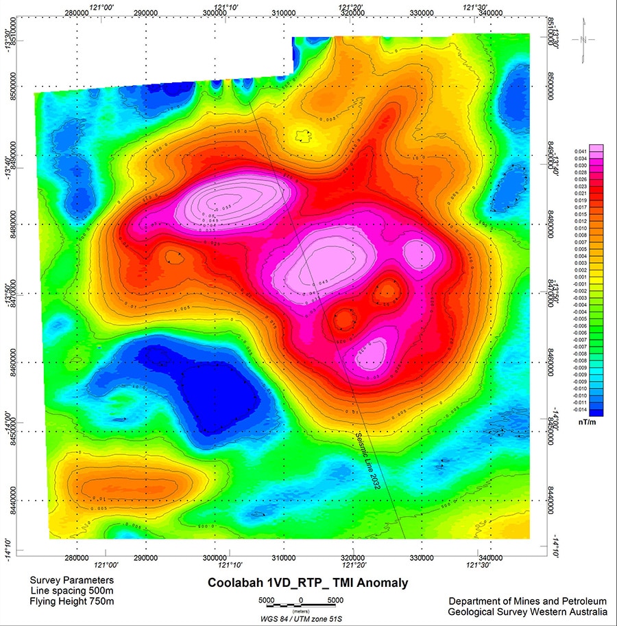
The Browse Basin has significant proven reserves of gas. The geology hosting these major reserves extends westwards into the Outer Browse where the environment is far more challenging, with water depths in excess of 2000m and the presence of volcanics at the prospective reservoir levels.
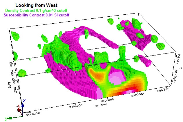
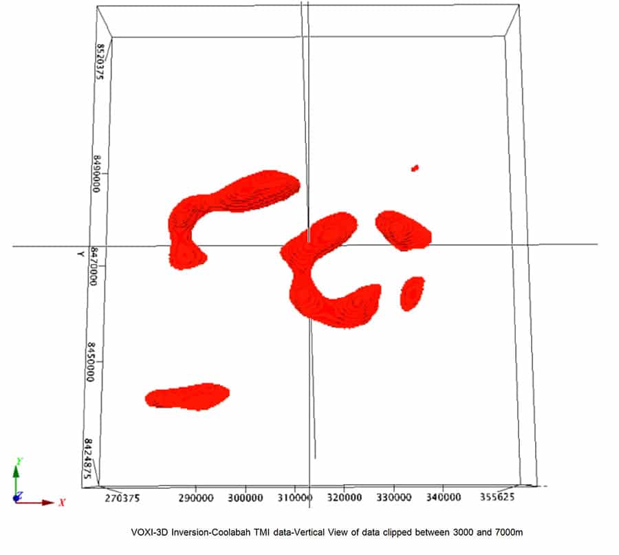
“The occurrence of variable thicknesses of mafic volcanics at reservoir level presents significant challenges to the interpretation of seismic data,” noted Pouliquen. She said previous interpretation of a particular anomaly, the Coolabah, has modelled its source as an approximately 2 km thick pile of highly magnetic volcanics at a depth of ~3 km. More recent work has suggested the possibility of an alternative interpretation: two thinner layers bounding a carbonate sequence. “So we ran a susceptibility inversion with VOXI and recovered the susceptibility distribution [figure 2 a, figure 2 b] which indeed suggested a more complex source than initially interpreted,” she said.
Although they still don’t have the full answer, “the modelling has brought new information which will help moving forward the decision making process,” she said. “This is an example where a voxel approach is more suitable than a layered based approach.”
Inversion of public domain data in the Gulf of Mexico
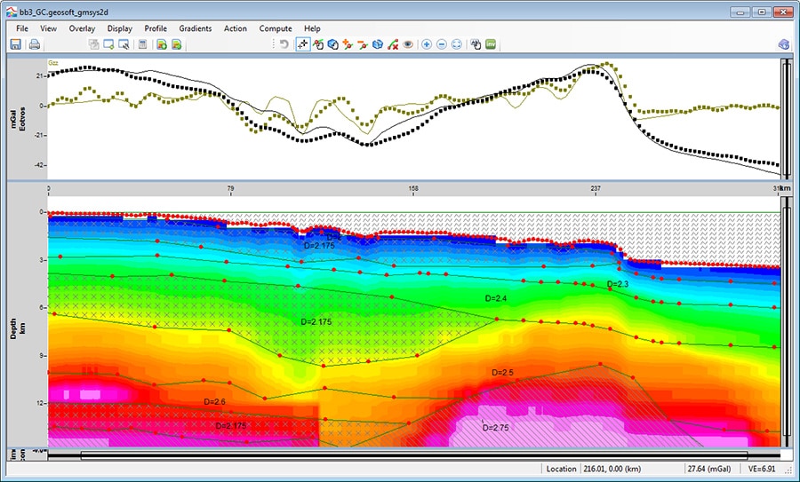
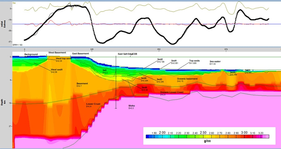
To expand, the next examples change scale and look at large regional studies. This work highlights how much useful information can result from a fairly simple and efficient approach using only openly available data, and with limited constraints. Keys to it are the use of Gzz, which is significantly less sensitive to errors in assumed Moho or basement depth than would result if attempting to model Gz, and a sufficient bathymetric coverage, independent from the gravity. The technique proved to be relatively simple and very low-cost; Pouliquen suggested that it is a good starting point for any new sedimentary basin—even well-understood basins like the Gulf of Mexico (figure 3).
Eastern Black Sea Basin
This was a project conducted by marine basin exploration firm Geology Without Limit in collaboration with the University of Southampton. Geosoft assisted by setting up their VOXI inversions (figure 4). The project objective was to determine crust types and geometry in the Eastern Black Sea Basin based on combined interpretation of reflection plus refraction seismic data and potential fields. All the results—seismic, 2D gravity modelling, magnetic interpretation, and VOXI—were integrated to produce a crustal type map.
The investigation showed no evidence of oceanic crust spreading in the basin but instead concluded in the presence of a thinned continental crust. Crust in this area was characterized by a higher density of rocks with weak magnetic properties.
Overall, the approach was similar to the above Gulf of Mexico example, but clearly with more constraints from seismic data, both to build the initial density model and for the VOXI inversion.
East African Margin: Public domain data inversion
This case leveraged a work which initially started as an evaluation for a Geosoft client. The idea was to show what can be done using public domain data with GM-SYS and VOXI to produce an interpretation of basement depth, crustal types, COB, and more.
As in the Gulf of Mexico case, the density models built in GM-SYS 2D were compared with the density model produced by VOXI (figure 5). Final COB interpretation incorporated the results of the 2D models, 3D models and gridded anomalies interpretation, as well as the work of previous authors in the area of interest.
By using public domain data, low cost was a major factor in this case. The regional inversion was of a large scale—about 10 million cells in the model. But it was a flexible approach: other target options were possible depending on input data (Gz or Gzz) and constraints. “We chose a tradeoff between computation time and resolution, so one limitation is the cell size of the voxel,” said Pouliquen.
Okavango Rift System: Large scale regional Magnetization Vector Inversion
All of the previous examples were primarily relying on gravity; however an important technological advance of VOXI is MVI. A good example is Geosoft’s recent delivery of a regional MVI inversion for the Geological Survey of Botswana. A large area to invert—mesh exceeded 35 million cells in volume—the challenge was to understand the Okavango Rift System.
The solution was to utilize the High Performance Computing capability in Microsoft Azure, the cloud-based VOXI Earth Modelling Service. It was modelled using rectangular mesh with Cartesian Cut Cells at the surface. The sheer size of the undertaking was impressive: it took 11 hours to run, leveraging from 576 cores and 4032 GB of RAM. But there is a distinct advantage in using MVI as opposed to conventional susceptibility inversion. Conventional susceptibility inversion assumes there is no remnant magnetization and that induced magnetization is in the same direction as the earth’s field. Both assumptions are often violated in practical exploration geophysics.
Imaging the Base of Salt: use of gravity data
Pouliquen wrapped up the presentation with discussion of another highly useful application of gravity data inversion: defining the base of salt.
Seismic data usually do a good job of defining the top of salt. And where the salt body is thin and tabular, it can often image the base of salt, too. But it has difficulty imaging the base of salt where the salt boundaries are not relatively flat. Where there is sufficient density contrast between the salt and underlying sediments, gravity, particularly high resolution gravity, can play an important role in defining that interface.
Pouliquen described a specific approach developed by Geosoft to address the inversion of the base of salt using gravity: VALEM, or Voxel Assisted Layered Earth Model. “It is a true hybrid approach which combines all the elements of the voxel and layered Earth models,” she said. An advantage is that VALEM is tightly integrated within GM-SYS 3D, so it works the whole time within a single environment. It leverages the workflows within GM-SYS to simplify and speed up the inversion modelling process and uses salt-specific pre-build constraints in VOXI.
These cases and recent examples show “how oil and gas explorers can take the best of both worlds and combine these approaches to optimize their modelling strategy,” summed Pouliquen. “And ultimately reduce uncertainty in their exploration workflow.”