


The Geological Survey of Norway designs a convenient tool that looks back in geological time and re-creates continental drift; helping the oil and gas industry to model offshore basins.
A quick glance at the eastern coastline of Brazil and the western coastline of the African continent and their jigsaw puzzle-like fit across the South Atlantic looks perfectly intuitive. But earth scientists know that’s less straight forward than it looks. It took at least 200 million years at the snail’s pace spreading of about two centimeters per year for them to get where they are today and apparently their drifting wasn’t in a straight line.
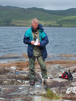
Mark Smethurst on the Isle of Mull, Scotland, carrying out paleomagnetic sampling of the Tertiary lava sequence. The paleomagnetic data were used to help date the lava flows and to reconstruct the North Atlantic Igneous Province preserved in Europe and Greenland.
At least that’s what the Geological Survey of Norway found when they applied a new tool they built to allow researchers to track these continental movements back in time. It’s a boon to the petroleum industry for modelling basins. Deep basins hundreds of kilometres off the coasts of Brazil and Angola, known as sub-salt basins, are yielding multi-billion barrel finds of crude in recent years; and the search goes on for similar deep offshore deposits elsewhere on the planet. Knowledge of pre-drift extensions and how they matched up eons ago is valuable in this pricey exploration territory.
“Putting a location in its paleogeographic context is interesting when trying to establish the sources of far travelled sediment—they may be on another tectonic plate,” explains Mark Smethurst, Senior Geophysicist with the Geological Survey of Norway, who led development of the software tool. One needs to know the tectonic framework for a deforming plate margin and the development of rifts; to establish the total magnitude of extension across plate boundaries, he says.
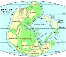
The concept behind it, at least, seems relatively simple. The earth’s plates have been in constant motion relative to one another for at least two and a half billion years. Mathematically, the translation of a plate from one of these places to another can be described by a rotation around an Euler pole, or pivot point—whose geographic position can be expressed in latitude and longitude together with its rotation in degrees.
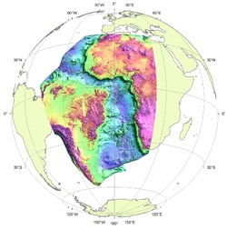
So one way to look back in geological time to examine ancient plate locations is to use these Euler relationships to rotate present day positional information back in time. “Rotating magnetic and gravity anomalies for two now widely separated plates back to their original adjacent positions—for example data for South America and Africa or for the Falklands and southern Africa—permits the correlation of anomalies and pre-drift geology between the plates,” says Smethurst.
“The point about an Euler rotation is simply that the translation of an object from one place to another on the surface of the sphere can be described by an Euler pole of rotation where the pole is a rotation axis passing through the centre of the Earth (assuming it is spherical),” continues Smethurst. But, he adds, in some cases several rotations would be in order. “The more complicated the motion of the object through time, the more rotation components you need to describe it.”
Smethurst and his team set out to design a tool to be used within Geosoft. They wrote a rotation algorithm that can be implemented in Oasis montaj; functioning as a GX (Geosoft Executable) routine. The function reads spatial co-ordinates from any Geosoft database and writes rotated co-ordinates back to the same database.
“We have stand alone plate reconstruction packages that produce paleogeographies and analyze plate motions,” says Smethurst. “And we use Oasis montaj and ArcGIS a great deal, so it is often convenient to rotate (reconstruct) features and data sets in the software packages we happen to be working in—rather than port data to a separate software package, reconstruct them, and bring them back. The basic building block used in producing plate reconstructions is the rotation on the sphere algorithm. It was therefore relevant to create a rotation on the sphere GX for montaj and a similar plug-in for ArcGIS.”
Although the tool is simple in concept, a user still needs knowledge about past plate movements for it to be effective, i.e. someone needs to specify accurate Euler pole values or the output may be misleading. If it is the user, how would he or she know what Euler value to input for example if he or she wished to know what a particular geology looked like 150 million years ago?
Smethurst explains. “The most primitive method of deriving original rotation parameters is through fitting continents together manually by simply matching their boundaries,” he says. “Otherwise one can use ocean floor magnetic anomalies and fracture zones to determine relative motions between plates. Paleomagnetic study data also provide a method of positioning continents but this provides control only on paleo-latitude and orientation, not longitude.”
And, he says, there are many researchers working on restoring continents and other features, like large igneous provinces, back to their original positions on Earth. These data can be mined and applied for Euler value inputs. “Euler rotation parameters appear in publications,” he says, but adding a caution: “however, extensive suites of rotations that describe the motions of most plates though long periods of geological time are seldom unfolded for all to see. Some projects, like EarthyByte/GPlates offer rotation parameters for all to use (if referenced properly) but these may not be the most up-to-date rotation histories.” Otherwise, he adds, industry participates in commercial and semi-commercial initiatives involving the supply of plate reconstruction software and plate rotation (motion) models.
Overall, “the need for doing plate reconstructions if of course to study plate tectonic processes,” says Smethurst. And that is particularly attractive to oil and gas explorers. “In my experience the hydrocarbon exploration industry has a very strong interest in establishing the paleogeography of the regions they are interested in,” he says. “We are talking about restoring now far separated plate margins back to their original relative positions, looking at their paleo-latitudes, their likely positions in climate zones, the rate of convergence and divergence of plates and what tectonic scenario this would create along plate margins.”
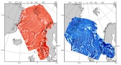
It’s not just the oil and gas industry. One of the Survey’s main findings is of interest to the academic world as well, and has supported the knowledge base of ancient continental drift for earth scientists. In this application, Smethurst and his team applied the tool to plate motions in the South Atlantic Ocean. “We reconstructed South America and Africa, including potential field data for the two areas,” he says, “to compare the geometries of the continental shelves on each side of the ocean and to look for structures internal to South America that could reasonably have permitted the South Atlantic to open sequentially from the south to the north.” That is, he explains, the southern part of South America had to move away from Africa while the northern part remained firmly attached.
It was an intriguing and useful conclusion. “Fitting South America and Africa back together creates an overlap between the two continent-ocean boundaries,” says Smethurst. “This is natural because both continental margins were extended before the ocean tract developed. Measuring the overlap provides an indication of the total amount of pre-drift extension in the two margins – useful to the petroleum industry in basin modelling.”