


Ireland’s ongoing effort to map the geology of the country has uncovered a belt of volcanic rocks in the North Midlands underneath the carboniferous cover that blankets most of the area.
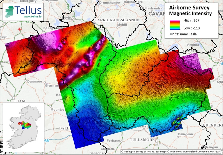
Maps generated from an airborne electromagnetic, magnetic and radiometric survey flown as part of the Geological Survey of Ireland’s (GSI) Tellus programme show prominent bands of highly magnetic volcanic rocks that are up to several kilometres deep and associated with a major fault that runs northeast through Ireland to Scotland.
The new information helps complete Tellus, Ireland’s first geoenvironmental mapping project, which began in 2007 and aims to survey 50% of the country by the end of 2017. The findings may also be significant for mineral exploration.
“What’s interesting from a minerals point of view is that this newly recognised piece of Ireland’s crust could be a source of base metal (lead-zinc) deposits that occur within overlying Carboniferous rocks,” says James Hodgson, geophysics programme manager for Tellus. “It’s possible that the volcanics indicate a pathway for mineralisation.”
The airborne geophysical data covering 32,000 line kilometres also reveals a cluster of small magnetic bodies that represent the remnants of 330 million year old volcanoes in the area.
The GSI expects to drill some of the magnetic anomalies in order to collect more geologic detail about the rocks and their role in the formation of Ireland and the development of mineral deposits.
“Some of the strong, deep magnetic signatures coming from the basement rocks do not necessarily agree with the current understanding of the crustal structure of Ireland,” says Hodgson. “That’s one question we need to answer: what is causing these unexpected features in the magnetics?”
CGG Airborne, which flew the survey on behalf of the government, has published a logistics and processing report that details the parameters of the work. Hodgson says the GSI will release the resulting data as soon as possible, so that industry and academia can begin using the new information.
Meanwhile, a geochemical team will start soil sampling in County Mayo to the west of the survey area. The combination of geophysical and geochemical data collected is expected to have a broad range of applications in agriculture, mapping radon concentrations, groundwater protection and mineral exploration in the midlands.
Tellus (named after the Roman goddess of the earth) is a regional mapping project that combines airborne geophysical and geochemical surveys of Ireland. Since its inception, Tellus has covered about 25,000 square km, stitching together the island’s geology in a way that has never been attempted before.
In 2008 the project won the Mining Journal’s Outstanding Achievement Award for its first phase over Northern Ireland. Tellus has since covered the border region, the midlands, and is currently in its fourth phase over eastern Ireland, including rural Dublin.