


As any earth scientist knows, earthquakes are notoriously difficult to predict. It’s clear to most other people too—we’ve all witnessed the devastating effects of earthquakes in populated areas; especially where there was no prior knowledge of subsurface faults.
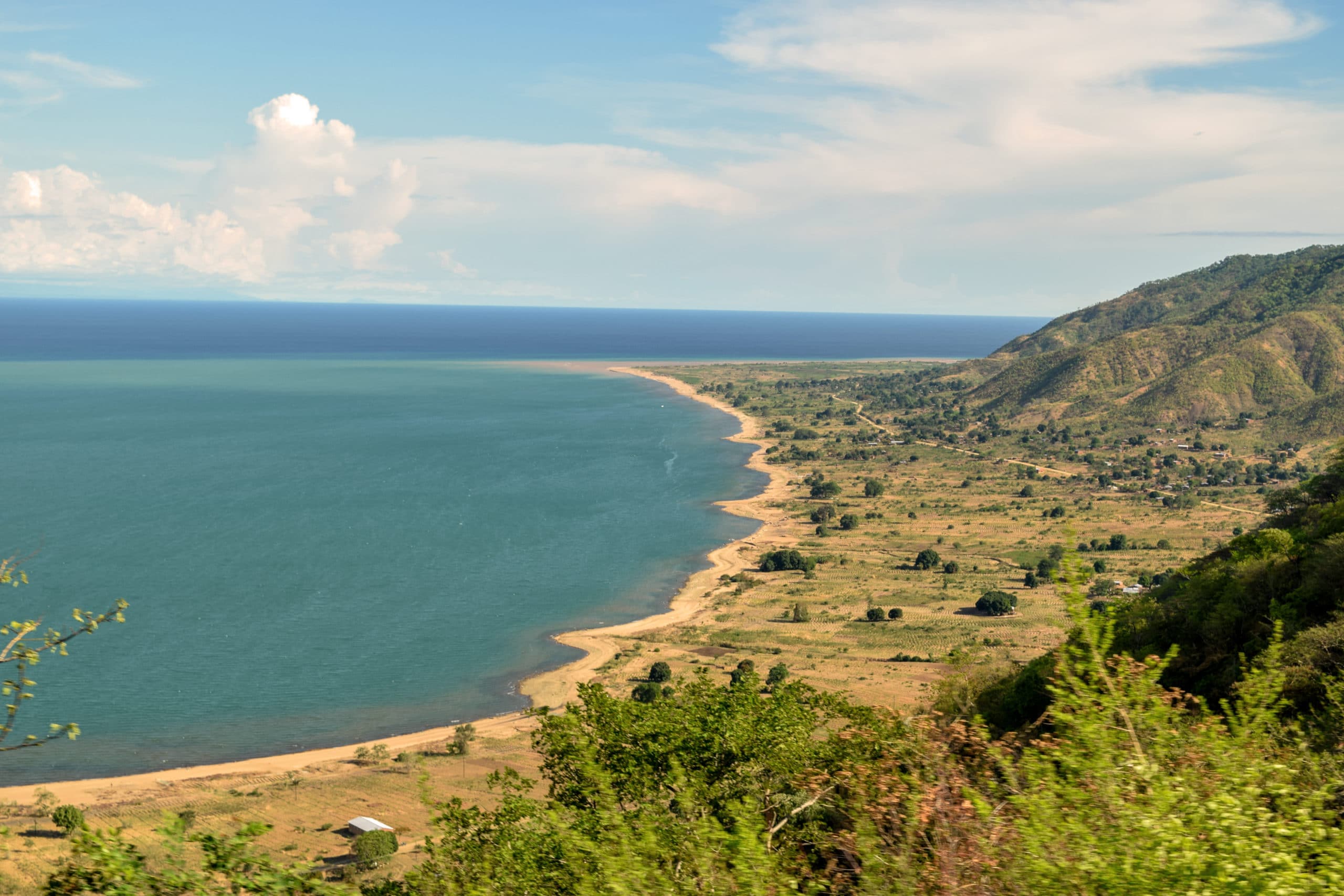
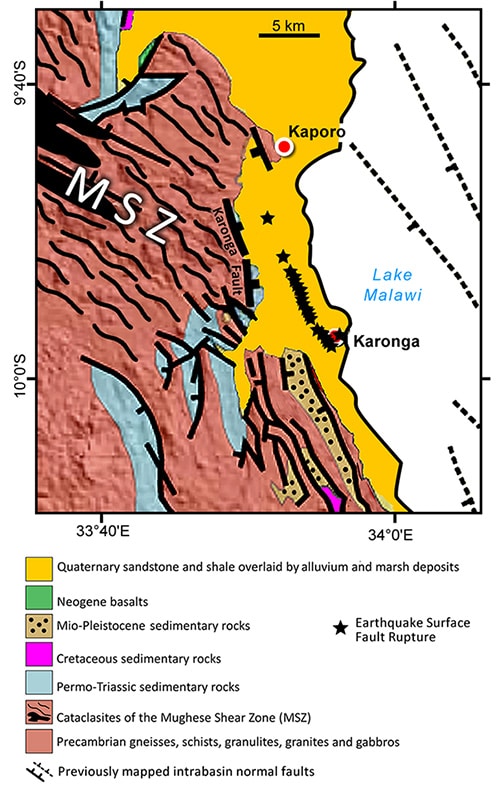
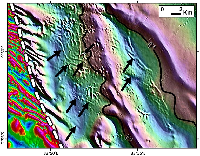
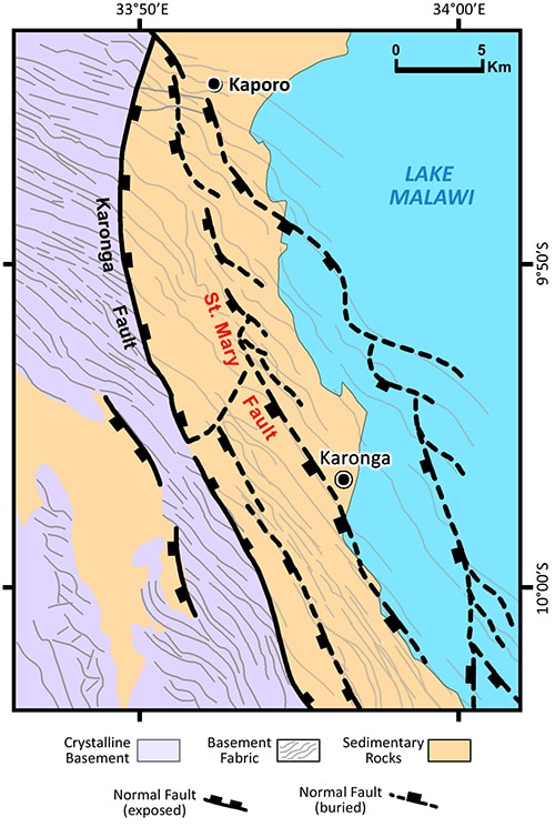
Folarin Kolawole and his team used existing aeromagnetic data to elucidate the relationship between fault segments, pre-existing basement fabric and the locations of surface faulting related to the 2009 Mw 6.0 Karonga, Malawi, earthquake along the hinge zone of a segment of the Malawi Rift.
As part of his Master’s degree program at Oklahoma State University, a research project by Folarin Kolawole has made progress in advancing the ability to identify potential locations and intensities of earthquakes in a rift zone.
Kolawole, now a PhD student at the University of Oklahoma’s ConocoPhillips School of Geology and Geophysics, integrated temporal aeromagnetic data and recent earthquake data to address the longstanding question of the role preexisting Precambrian structures play in modulating strain accommodation and subsequent ruptures leading to seismic events within an active rift system.
“The East African Rift System is the largest and most enigmatic continental rift system on our planet,” he says, “and my research investigated how pre-existing planes of weaknesses help to localize seismic crustal deformation in rift segments such as the Malawi Rift that have minimal magmatic activity.”
He and his team used existing aeromagnetic data to elucidate the relationship between fault segments, pre-existing basement fabric and the locations of surface faulting related to the 2009 Mw 6.0 Karonga, Malawi, earthquake along the hinge zone of a segment of the Malawi Rift. By applying derivative filters and depth-to-magnetic-source modeling, they identified and constrained the trend of the Precambrian metamorphic fabrics and correlated them to the three-dimensional structure of buried basement faults.
Kolawole utilized the capabilities of Geosoft Oasis montaj for processing the data. His data came in as a grid file, so he first reduced it to the magnetic pole in order to correct for its skewness due to the location of the study area with respect to the earth’s magnetic poles.
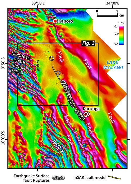
“I used filters such as vertical derivative and tilt-angle derivative to enhance the magnetic fabric of the basement rocks in areas where they are exposed and buried at shallow depths,” he explains. “I used the same filters to enhance the magnetic lineaments associated with buried normal faults within the study area. Both derivatives are very powerful in enhancing vertical truncations in a magnetic source such as basement rocks.” He then enhanced the discontinuities along the fault-related lineaments in order to highlight features that may provide insight into the geometry of the faults, to provide structural information. Due to the lack of subsurface information, he had to rely on potential fields for information on the depth-to-basement in areas dominated by sedimentary rocks. “So, I modelled depth-to-magnetic source in Oasis montaj by using the Source Parameter Imaging (SPI) technique,” he says.
He says he found the mix of user friendliness and user control of Oasis montaj really helpful. “A lot of scientific software applications are too user friendly to the extent that they do not allow the user to have a good measure of control on the parameters that govern the data processing,” he says. “I also like the fact that I can apply the filtering tools in the software to other kinds of datasets other than potential fields data such as elevation data, bathymetric data etc. The updated 3D visualization capabilities in Oasis montaj allowed me to plot the earthquake distribution in 3D on the display of my hill-shade aeromagnetic map.”
The study showed a cost-effective and efficient way of delineating causative faults associated with damaging seismic events, therefore helping earthquake mitigation efforts. “Careful filtering and interpretation of high-resolution aeromagnetic data in tectonically-active areas with large human populations can be extremely useful for assessing the seismic hazards,” sums Kolawole. “Secondly, the study demonstrated the connections between earthquake clusters, their causative faults and the pre-existing basement fabric that controlled the development of the faults. Considering these components in the context of an entire rift basin, we found that the pre-existing basement fabric plays a complementary role in the weakening, flexing and deformation of the crust—accompanied by seismic ruptures—beneath the basin.”
Kolawole’s doctoral research extends the focus. “I have started integrating laboratory study of rock strength with aeromagnetics and 3D seismic data to study fault systems in Oklahoma where we are having a lot of earthquakes, and results are really interesting,” he says. And he’s continuing work on the East African Rift System, not just its structural geology or tectonics-related problems, but also the petroleum system of the rift where good aeromagnetic and gravity data are available.
“It is good to see how much information these limited data can provide if you know how to use them,” he says.